• Skip to primary navigation
  • Skip to main content
  • Skip to primary sidebar

Weatherboy

Weatherboy Weather News, Maps, RADAR, Satellite, and Forecasts.

  • Local
  • Earth Science News
  • RADAR
  • Current Warnings
  • Satellite
  • Current Maps
  • Forecast Maps
  • Video

Dozens Report Shaking from Morning Earthquake in Tennessee

by Weatherboy Team Meteorologist - September 26, 2025

The epicenter of today's earthquake is at the orange dot inside the colored, concentric circles. Image: USGS
The epicenter of today’s earthquake is at the orange dot inside the colored, concentric circles. Image: USGS

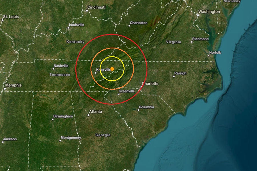
Dozens of people reported to USGS that they felt an earthquake during the early morning hours. According to USGS, at 4:37 am today, a relatively weak magnitude 2.3 earthquake struck from a depth of 8.2 km near the town of Greeneville, Tennessee. The area hit isn’t far from where a magnitude 4.1 earthquake struck in May; that quake generated more than 30,000 reports of shaking into the USGS.

According to USGS, earthquakes with a magnitude of 2.0 or less are rarely felt or heard by people, but once they exceed 2.0 , more and more people can feel them. While damage is possible with magnitude 3.0 events or greater, significant damage and casualties usually don’t occur until the magnitude of a seismic event rises to a 5.5 or greater rated event.

Due to the intensity of today’s earthquake, no reports of damage and injuries are expected.

Earthquake hazards are possible in broad areas of the United States. Earthquake hazard map showing peak ground accelerations having a 2 percent probability of being exceeded in 50 years, for a firm rock site. The map illustrates such hazards and is based on the most recent USGS models for the conterminous U.S. (2018), Hawaii (1998), and Alaska (2007). Image: USGS


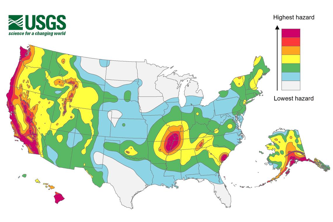
Earthquakes like the one that this morning in the eastern part of Tennessee are unlikely associated with the New Madrid Seismic Zone, an area of ongoing seismic activity located near the Mississippi River. However, while USGS says western Tennessee has a higher frequency of damaging earthquake shaking, the risk isn’t that low in eastern Tennessee.  In the area of this most recent quake, USGS says its likely this area would see 50-100 damaging earthquakes over 10,000 years. While this number is low, it is much higher than it is elsewhere in the eastern half of the United States, where it’s likely to have 10 or less earthquakes over the same period.


Primary Sidebar

Sponsored Ad

Search

Latest News

  • IMPACT! CME Arrives on Earth, Geomagnetic Storm Building; Expected to be SEVERE
  • SEVERE Geomagnetic Storm (G4) Now Expected November 12
  • Earth is Now Picking Up Radio Signals from 3I/Atlas Interstellar Object
  • Shocking New Images of 3I/Atlas Adds to Alien Spaceship Theory by Harvard Scientist
  • Last Year for Farmer’s Almanac; Publisher Calls it Quits
  • Harvard Scientist Tracking 3I/Atlas Believes New Photos May Show Alien Spacecraft Engines
  • Geomagnetic Storm Watch for MODERATE Storm November 8
  • Alien Spaceship or Unusual Comet? More Demand Answers on Color/Speed/Shape Shifting Object in Space
About | Careers | Contact | Contests
Terms | Privacy | Ad Choices
Weatherboy is a (R) Registered Trademark of isarithm LLC, All Rights Reserved.
All content herein is Copyright by Isarithm LLC 1997-2022

Insert/edit link

Enter the destination URL

Or link to existing content

    No search term specified. Showing recent items. Search or use up and down arrow keys to select an item.