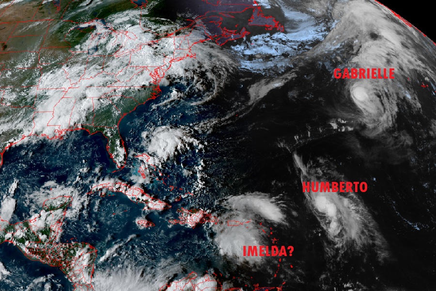
The U.S. East Coast is on alert now that Tropical Storm Humberto has formed in the Atlantic Ocean and a second tropical cyclone is likely to form in the coming days. While Hurricane Gabrielle is heading east towards the Azores and Europe, Humberto and what could be Imelda will be heading north and west and direct impacts to the U.S. East Coast cannot be ruled out at this time.
Tropical Storm Humberto is located about 550 miles east-northeast of the Northern Leeward Islands. With winds of 40 mph and a minimum central pressure of 1008 mb or 29.77″, the storm is moving west-northwest at 15 mph. The National Hurricane Center (NHC) says a west-northwest to northwest motion is expected over the next several days with a slower forward speed. Steady strengthening is forecast during the next several days and Humberto is forecast by the NHC to become a hurricane by the weekend.
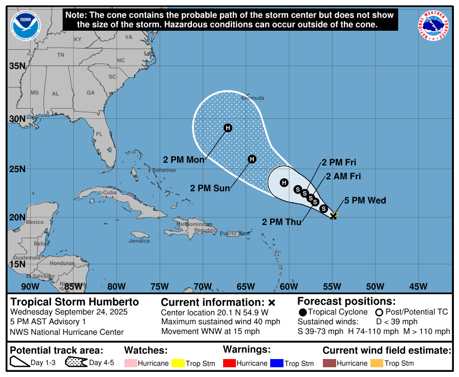
Humberto is currently too far from any land to prompt the issuance of any kind of tropical storm or hurricane watch or warning. That could could change this weekend as more is known about the storms strength and future track. It is too soon to know whether Bermuda or the U.S. East Coast could be directly impacted by this storm.

Complicating Humberto’s future track is a second tropical cyclone taking shape in the Caribbean. This third system in the Atlantic could become the second tropical cyclone threat to the U.S. East Coast in the next week or so. According to the NHC, showers and thunderstorms have increased but remain disorganized in association with a tropical wave over the northeastern Caribbean Sea. They expect this wave to move west-northwestward around 10 to 15 mph, spreading heavy rainfall and gusty winds into Puerto Rico and the Virgin Islands today, and across the Dominican Republic
beginning tonight. The system is then expected to slow down and turn northwestward when it reaches the southwestern Atlantic late this week.
“Environmental conditions are forecast to be more conducive for development in a few days, and a tropical depression is likely to form when the disturbance is in the vicinity of the Bahamas,” warns the National Hurricane Center. They add, “Interests in the Virgin Islands, Puerto Rico, the
Dominican Republic, the Turks and Caicos Islands, and the Bahamas should monitor the progress of this system.”

An Air Force Hurricane Hunter Aircraft is enroute to perform a system survey to gather data from the surrounding environment. That analysis and ongoing computer analysis of data being collected by weather satellites and other sources will help give meteorologists an idea of how this system will evolve, how strong it’ll get, and where it’ll go. With this new system and Humberto located close to each other, they could also interact with each other and influence the other’s track and intensity.
Should this second system become a named tropical storm as it develops into a tropical cyclone it would be given the next name available on the Atlantic storm name list which is Imelda.
