The Governor of Florida has declared a State of Emergency across 41 counties in Florida that could be impacted by a developing tropical cyclone in the coming days that the National Hurricane Center expects to intensify into a significant hurricane. As the threat to Florida takes shape, the National Hurricane Center (NHC) has already started issuing advisories for the Sunshine State.
“Because of the foregoing conditions, which are projected to constitute a major disaster, I declare that a state of emergency exists in Alachua, Bay, Bradford, Calhoun, Charlotte, Citrus, Collier, Columbia, Dixie, Escambia, Franklin, Gadsden, Gilchrist, Gulf, Hamilton, Hernando, Hillsborough, Holmes, Jackson, Jefferson, Lafayette, Lee, Leon, Levy, Liberty, Madison, Manatee, Marion, Monroe, Okaloosa, Pasco, Pinellas, Santa Rosa, Sarasota, Sumter, Suwannee, Taylor, Union, Wakulla, Walton, and Washington counties,” Florida Governor Ron DeSantis declared. The Emergency Declaration grants special powers to state resources to deal with the threats that a tropical cyclone could create with the state.
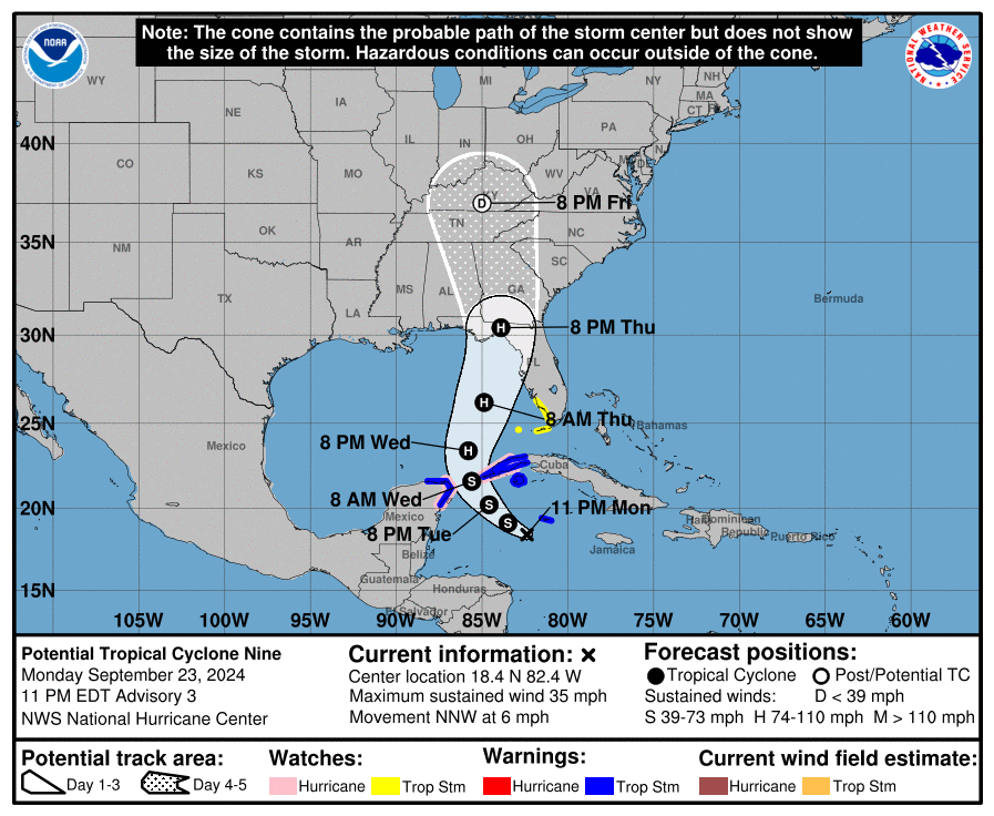
Right now, the developing tropical cyclone is located about 100 miles southwest of Grand Cayman and about 290 miles southeast of the western tip of Cuba. Maximum sustained winds are near 35 mph while the estimated minimum central pressure is 1002 mb or 29.59″. The disturbance, now known officially as Potential Tropical Cyclone #9, is moving to the north-northwest at 6 mph.

The system of concern is moving toward the north-northwest near 6 mph. According to the NHC, a northwestward motion is expected on Tuesday and Tuesday night, followed by a faster northward to north-northeastward motion on Wednesday and Thursday. On the forecast track, the center of the system is forecast to move across the northwestern Caribbean Sea through Tuesday night, and then over the eastern Gulf of Mexico on Wednesday and Thursday. While maximum sustained winds are near 35 mph now with higher gusts, strengthening is expected during the next few days, and the system is forecast to become a hurricane on Wednesday and continue strengthening on Thursday as it moves across the eastern Gulf of Mexico.
According to the National Hurricane Center, the tropical cyclone is forecast to be a major category 3 hurricane when it makes landfall, likely along the Florida panhandle, during the PM hours on Thursday. It is possible the storm could be stronger than that and the NHC will refine its forecast in the coming days as the system takes shape.
When the disturbance becomes a tropical storm, it will be named Helene. As it strengthens more into a hurricane, it will keep the Helene name.
For now, a Storm Surge Watch has been issued along the southwest coast of Florida from Bonita Beach to Flamingo. A Tropical Storm Watch has been issued along the southwest coast of Florida from Bonita Beach southward to Flamingo. A Storm Surge Watch means there is a possibility of life-threatening inundation, from rising water moving inland from the coastline. A Tropical Storm Watch means that tropical storm conditions are possible within the watch area, generally within 48 hours.
The best time to prepare for a landfalling hurricane is well before one strikes when conditions are fair and dry and you can calmly execute your hurricane action plan to stay safe and prepared. #Helene #FLwx https://t.co/oRYl8dZEXx
— the Weatherboy (@theWeatherboy) September 24, 2024
“Interests along the northeastern Gulf Coast, including the Florida Panhandle and the Florida west coast, should monitor the progress of this system. Additional watches or warnings will likely be required on Tuesday,” warns the National Hurricane Center.
“The system is expected to intensify into a major hurricane before it approaches the northeastern Gulf Coast on Thursday,” the NHC wrote in an update this evening. “While it is too soon to pinpoint the exact location and magnitude of impacts, the potential for life-threatening storm surge and damaging hurricane-force winds along the coast of the Florida Panhandle and the Florida west coast is increasing. Hurricane Watches and additional Storm Surge watches will likely be issued for a portion of that area Tuesday morning, and residents should ensure they have their hurricane plan in place.”
While the U.S. will see the eventual impacts of this system, Potential Tropical Cyclone #9 will also bring heavy rain to portions of the western Caribbean, which will cause considerable flooding and mudslides across western Cuba.
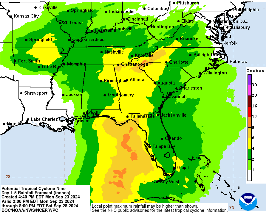
After landfall, heavy rainfall will likely result in locally considerable flash and urban flooding across portions of Florida, with isolated flash and urban flooding possible across the Southeast, Southern Appalachians, and the Tennessee Valley Wednesday through Friday. Minor to isolated moderate river flooding will be possible.