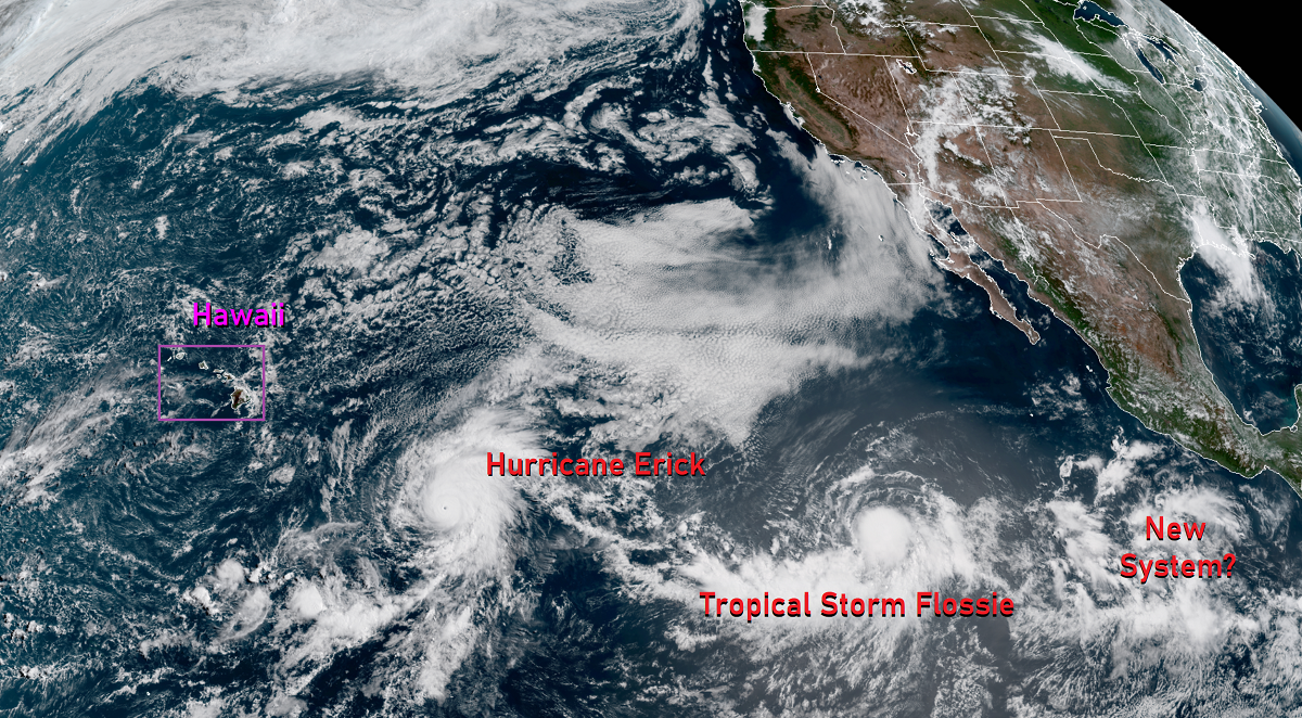
The Eastern Pacific Hurricane Basin is alive with activity, with a powerful category 3 hurricane, a strong tropical storm almost ready to become a hurricane, and a new tropical disturbance that could become a tropical cyclone over time, all marching west in the general direction of Hawaii.
In the latest update from the Central Pacific Hurricane Center (CPHC) in Honolulu, Hawaii, the center of Hurricane Erick was located near latitude 13.4 North, longitude 142.8 West. Erick is moving toward the west near 17 mph. According to the CPHC forecast, a turn toward the west-northwest at a slightly slower forward speed is expected later today; this west-northwest motion is forecast to continue through Thursday. Maximum sustained winds are near 115 mph with higher gusts making Erick now a category 3 hurricane, which is a Major Hurricane on the Saffir-Simpson Hurricane Wind Scale. Some additional strengthening is expected later today. However, by Wednesday, the CPHC is forecasting gradual weakening, with a more rapid weakening trend expected on Thursday.
For now, Erick’s hurricane-force winds extend outward up to 25 miles from the center and tropical-storm-force winds extend outward up to 105 miles. The estimated minimum central pressure is 966 mb or 28.53 inches.
Forecast guidance suggests the center of Erick will pass well south of Hawaii as a weaker Tropical Storm. However, a large field of moisture is likely to impact the eastern islands of Hawaii, with the Big Island bearing the brunt. More than a foot of rain could fall, especially on northern and eastern portions of Hawaii County. While gusty winds could impact the islands, the larger threat with Erick will be the rain. The core of sustained tropical force winds are not expected to impact Hawaii at this time.
While Erick spins about, Tropical Storm Flossie is gaining strength in its wake. In the latest advisory from the National Hurricane Center in Miami, Florida, the center of Tropical Storm Flossie was located near latitude 12.2 North, longitude 120.5 West. Flossie is moving toward the west near 15 mph. The tropical storm is forecast to turn toward the west-northwest later today, and then continue moving west-northwestward at 15 to 20 mph through the end of the week. Once the storm travels west of 140W, the Central Pacific Hurricane Center will take over issuing advisories and forecasts for it.
For now, Flossie’s maximum sustained winds are near 70 mph with higher gusts, just a few mph shy of becoming a category 1 hurricane . Flossie is expected to become a hurricane later today and could be near major hurricane strength by Thursday. Tropical-storm-force winds extend outward up to 80 miles from the center. The estimated minimum central pressure is 999 mb or 29.50 inches. Unlike Erick which is forecast to travel well south of Hawaii, Flossie may strike Hawaii’s Big Island head-on as a tropical storm. While Flossie may not have as much moisture to work with as Erick, the core of severe tropical-storm force winds may come ashore in Hawaii, impacting especially eastern Hawaii Island with strong winds 5 days after Erick’s impacts.
Behind Flossie, in the region where both Erick and Flossie formed, a third system appears to be taking shape. The National Hurricane Center is monitoring it for potential development as the disturbance heads west. Tropical cyclone formation is not likely here for at least 48 hours, but that could change as the week continues. As with Erick and Flossie, this disturbance is also heading west over open waters of the Pacific for now. It is too early to know what impacts, if any, this third system may have on Hawaii. If impacts were to materialize, it would likely be more than 7-10 days from now.
NOAA’s Central Pacific Hurricane Center (CPHC) Director, Chris Brenchley, described to us today how his Honolulu team coordinates, collaborates, & even swaps staff with Miami-based National Hurricane Center (NHC) to keep America #HurricaneStrong?@NWSHonolulu pic.twitter.com/W1WM2EeXeC
— the Weatherboy (@theWeatherboy) May 23, 2019
People in Hawaii are urged to have their Hurricane Action Plans in order now and have at least 2-weeks worth of supplies on hand before the arrival of these storms.
