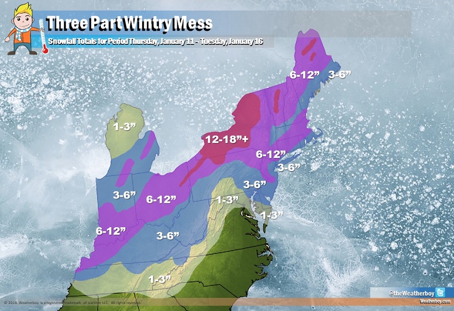
A series of evolving storm systems will bring snow to the Northeast, Great Lakes, and Mid Atlantic in the coming days as 3 core weather-event-days drop significant precipitation across this part of the country.
The first of a 3-part event will unfold on Friday, bringing heavy rain far north into southern New England while dropping heavy snow on the back side of the storm just north of the Ohio River Valley. Rain will be heavy at times, especially over New Jersey, New York, Connecticut, Rhode Island, and portions of Massachusetts on Friday. Some thunderstorms are also possible, especially over New Jersey, Connecticut, and the New York City metro area. Flooding may be a concern, especially where some storm grates are covered by ice or snow.
The second part of the event unfolds on Saturday with cold, Arctic air rushing in from the west. Some locations could see a 30 degree temperature drop in less than 3 hours, leading to flash freezing of any untreated, wet surfaces. The drastic drop in temperatures will change any freezing rain that is falling to sleet and any sleet that is falling to snow in the northeast. Places north of New York City along the I-95 corridor to Boston could see a significant period of freezing rain and sleet before precipitation shuts off Saturday afternoon. It’ll be a race to see if the Arctic air can beat the departing precipitation in places like New York City and Philadelphia; if the Arctic air rushes faster than the precipitation can exit, plain rain falling in the morning could change to freezing rain and/or sleet. Snowflakes could also fall here Saturday afternoon, especially along and north of I-195 in New Jersey, but there should be no snowfall accumulation until the third part.
The third part arrives later Monday after a significant cool-down across the entire region on Sunday. A clipper system will drop in from the Great Lakes, producing additional light snowfall accumulations in the Great Lakes and Ohio River Valley. This system is expected to pick up some additional Atlantic moisture, dropping it as snow across the DelMarVa, New Jersey, and eastern New England. By the time this system exists the northeast late Tuesday, several inches of snow are likely to fall from northeastern Virginia into southeastern New England, including the I-95 corridor from Philadelphia to Boston.
