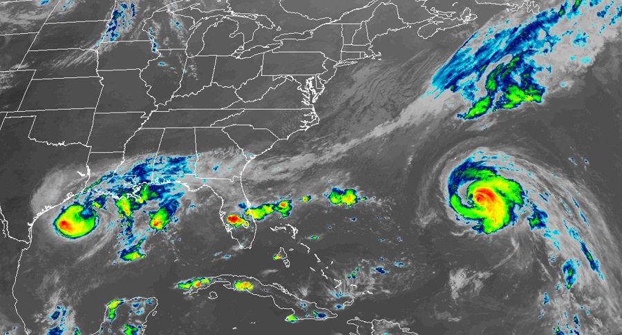
Experts with the National Hurricane Center in Miami, Florida are urging those in the path of Tropical Storm Beta and Hurricane Teddy to prepare for their respective impacts. A variety of watches and warnings are up for both as they inch their way closer and closer to land.
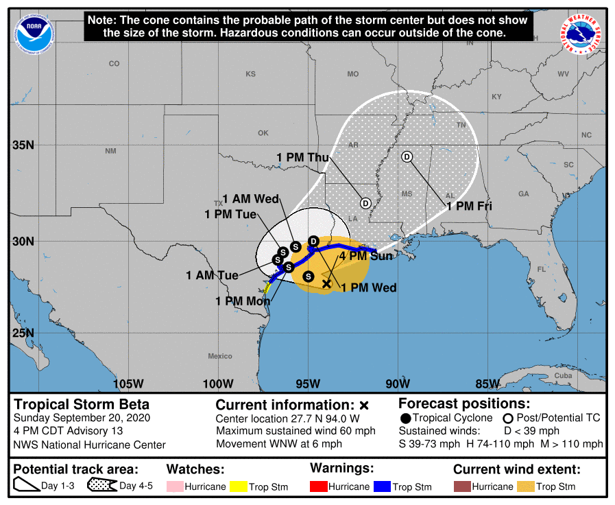
In the Gulf of Mexico, Tropical Storm Beta is moving a little faster towards the central Texas coast now. Located about 120 miles south-southeast of Galveston, Texas and about 155 miles east-southeast of Port O’Connor, Texas, Beta’s maximum sustained winds are 60 mph. The storm is moving to the west-northwest at 6 mph.
Due to Beta, a Storm Surge Warning is in effect from Port Aransas, Texas to Rockefeller Wildlife Refuge, Louisiana, including Copano Bay, Aransas Bay, San Antonio Bay, Matagorda Bay, Galveston Bay, Sabine Lake, and Lake Calcasieu. A Tropical Storm Warning is in effect from Port Aransas, Texas to Morgan City, Louisiana. A Tropical Storm Watch is also in effect from Baffin Bay to Port Aransas, Texas.
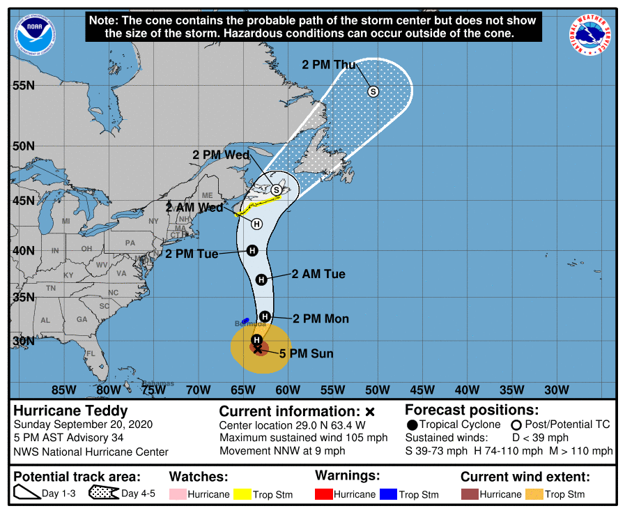
While Beta inches towards Texas, Teddy is getting closer to Bermuda, While Teddy should only brush by Bermuda, it looks like it could landfall with Nova Scotia. Because of the forecast, a Tropical Storm Warning is in effect for Bermuda while a Tropical Storm Watch is in effect for Nova Scotia from Lower East Pubnico to Canso.
A Storm Surge Warning means there is a danger of life-threatening inundation, from rising water moving inland from the coastline, during the next 36 hours in the indicated locations. Persons located within a Storm Surge Watch area should take all necessary actions to protect life and property from rising water and the potential for other dangerous conditions. In some areas, storm surge could exceed 5′.
A Tropical Storm Warning means that tropical storm conditions are expected somewhere within the warning area within 36 hours.
A Tropical Storm Watch means that tropical storm conditions are possible within the watch area, in this case within the next 36 hours.
Beta is moving toward the west-northwest near 6 mph and this general motion is forecast to continue for the next day or so. A decrease in forward speed and a sharp turn to the north and northeast is expected Monday night and Tuesday. On the forecast track, the center of Beta will continue to move toward the central coast of Texas and will likely move inland by Monday night, and remain close to the coast of southeastern Texas on Tuesday. Little change in strength is forecast during the next couple of days before Beta reaches the Texas coast. Weakening is anticipated once Beta moves inland.
Teddy, located 245 miles south-southeast of Bermuda, is moving to the north-northwest near 9 mph. A turn toward the north is expected tonight, and Teddy is then forecast to continue generally northward for another couple days. On the forecast track, Teddy will approach Bermuda tonight, and the center should pass east of the island Monday morning. Teddy is forecast to be approaching Nova Scotia late Tuesday or Wednesday.
Teddy is much stronger than Beta with maximum sustained winds of near 105 mph with higher
gusts. Little change in strength is forecast, and the system is expected to remain a large and powerful hurricane through Tuesday, then become a strong post-tropical cyclone on Wednesday. Teddy is also a large hurricane. Hurricane-force winds extend outward up to 80 miles from the center and tropical-storm-force winds extend outward up to 230 miles.
Because of its size, Teddy will bring tropical storm force conditions to Bermuda even with the center of circulation forecast to pass well east of the island.
Tropical storm force winds will also lash the Texas coast as Beta approaches it.
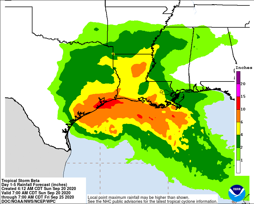
Both storms will produce heavy rain where they go, with Beta dumping even more than Teddy due to its slow speed. An additional 10-15″ of rain is possible near Galveston and Houston, Texas, which could create extensive flood problems into the new week.
