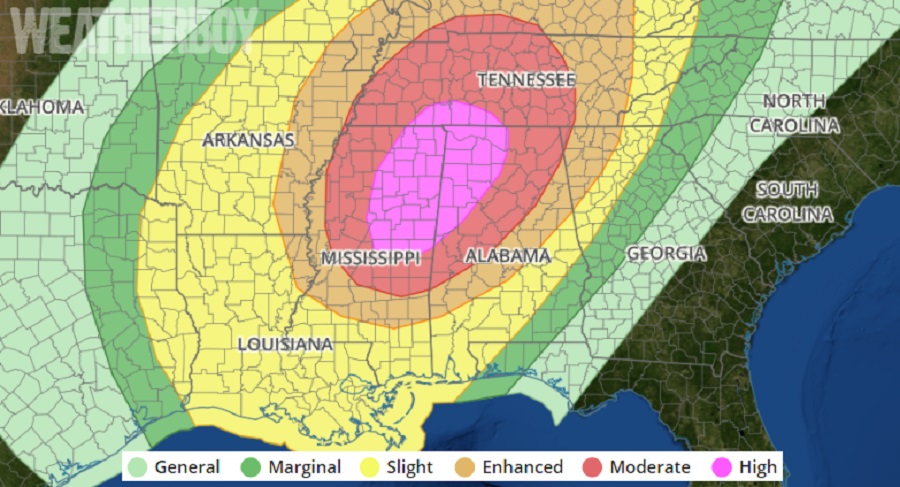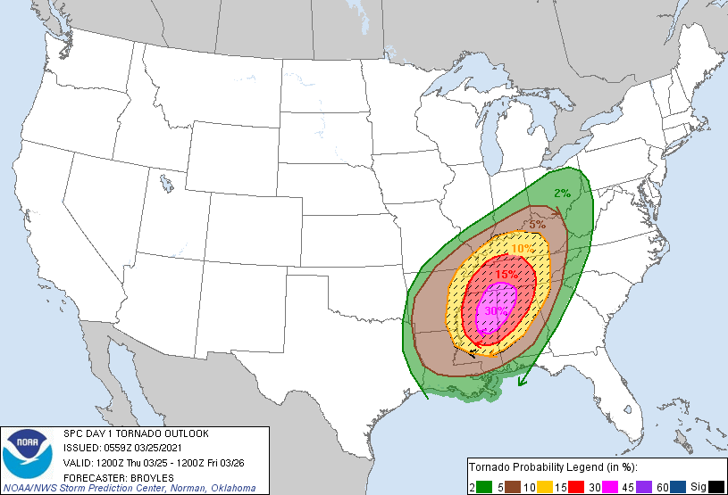
There is a high risk of severe thunderstorms today across portions of central, eastern and northern Mississippi, into northwestern Alabama and southern Tennessee. According to the National Weather Service’s Storm Prediction Center (SPC), a tornado outbreak is expected with several strong, long track tornadoes. Due to this threat level, the SPC has issued the highest risk level they can in their daily Convective Outlook update, placing the area in danger under “HIGH.” This is the second time this young season that the SPC has used the “HIGH” risk ranking for storm activity.
An area of low pressure will move northeastward and deepen across the Arklatex and mid Mississippi Valley today. The low-level moisture combined with surface heating will result in a moderately unstable and volatile airmass by late morning. According to the SPC, a band of strong large-scale ascent, in advance of the shortwave trough, will move quickly northeastward across the Arklatex this morning. Convection appears likely to initiate around midday ahead of this band of ascent from southeast Arkansas southward into northeast Louisiana and eastward into southwest Mississippi. This cluster of thunderstorms is expected to organize and rapidly intensify, moving northeastward across central and northern Mississippi into northwestern Alabama during the afternoon. Moderate instability, strong deep-layer shear and impressive amount of lift on a large scale will be favorable for widespread severe thunderstorm development, and a significant tornado outbreak is expected.

Atmospheric conditions will become optimal for the development of tornadic storms. Supercells are forecast to develop rapidly after initiation across central
Mississippi early this afternoon and move quickly north-northeastward into northeast Mississippi. Across northeast Mississippi and northwest Alabama, conditions will become very favorable for long-track strong tornadoes. As the low-level jet consolidates and couples with the progressive mid-level jet, a violent long-track tornado will be possible.
A long-track tornado can be far more destructive and deadly than a typical tornado. Typical tornadoes are relatively short-lived, lasting on the ground for only minutes across a small area. However, long track tornadoes can be on the ground for hours and cover dozens of miles or more of land. Because of the chance of several long track tornadoes in this area today, people must be on high alert for life-threatening weather conditions that could develop over a very short period of time.
The cluster of severe thunderstorms is expected to move from parts of northern Mississippi and northern Alabama into the Tennessee Valley late this afternoon and early this evening. Supercells and bowing line segments will likely be severe, producing wind damage, more tornadoes and large hail. Hailstones greater than 2″ in diameter may occur with the stronger updraft cores. The wind damage threat is forecast to become more widespread as a squall line organizes along a cold front in the Mississippi Valley. This line of severe storms is forecast to move quickly eastward across the Ohio and Tennessee Valleys this evening, producing widespread wind damage. Wind gusts of greater than 70 mph will be possible.
Further north in areas near the Ohio River, instability is forecast to be considerably weaker than in areas to the south. However, enhanced lift and strong deep-layer shear will make severe storms even possible there. As storms move north-northeastward across the Ohio Valley this evening, isolated large hail and wind damage will accompany supercells and bow echoes. An isolated tornado threat will also exist.