Major Hurricane Rafael, which rapidly intensified into a category 3 hurricane on the Saffir-Simpson scale earlier today, has crossed Cuba and has arrived into the Gulf of Mexico as a category 2 storm. While it was initially forecast to move to the north of Cuba into the northern central Gulf of Mexico, it is now forecast by the National Hurricane Center (NHC) to spin about in the Gulf of Mexico over a longer duration and head west.
Rafael is the first category 2 hurricane in the Gulf of Mexico in November since Ida in 2009.
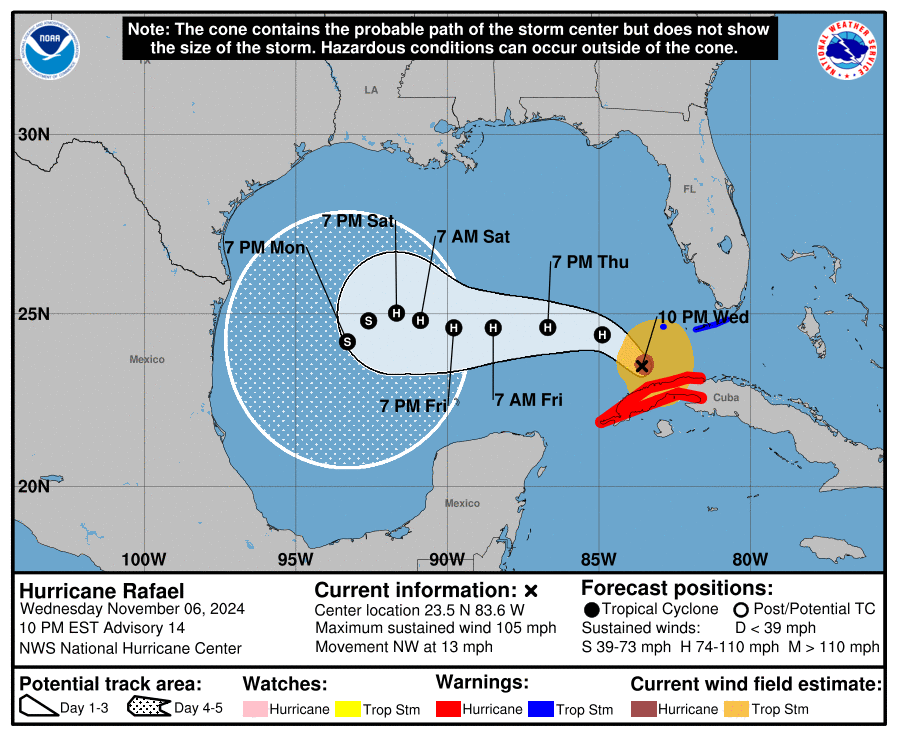
As of the latest update from the NHC, Rafael was about 80 miles west-northwest of Havana, Cuba and about 135 miles west-southwest of Key West, Florida.
With maximum sustained winds of 105 mph, Rafael’s minimum central pressure was 969 mb or 28.62″.
A Tropical Storm Warning is now in effect for the Lower and Middle Florida Keys from Key West to west of the Channel 5 Bridge and the Dry Tortugas. A Tropical Storm Warning means that tropical storm conditions are
expected somewhere within the warning area.
Rafael is moving toward the northwest near 13 mph for now. A general northwestward motion is anticipated tonight. A turn toward the west at a slower forward speed is expected on Thursday, with this general motion continuing through Saturday. On the forecast track, Rafael is expected to move away from western Cuba over the southeastern Gulf of Mexico tonight. Rafael is then forecast to move over the southern Gulf of Mexico for the next few days. This is a dramatic change from earlier forecasts that brought the storm to the central U.S. Gulf coast.
Some weakening is possible tonight and Thursday,with little change in strength expected on Friday.
Tropical storm conditions are expected in parts of the lower and middle Florida Keys through tonight. Rainfall totals of 1-3″ are expected for the Lower and Middle Florida Keys. A storm surge of 1-3′ if possible here. There is also the risk of isolated tornadoes and waterspouts across the Lower Florida Keys from the hurricane.
Swells generated by Rafael are expected to affect much of the northwestern Caribbean during the next day or so and will also spread across most of the Gulf of Mexico from east to west late this week into the weekend. These swells are likely to cause life-threatening surf and rip current conditions.
