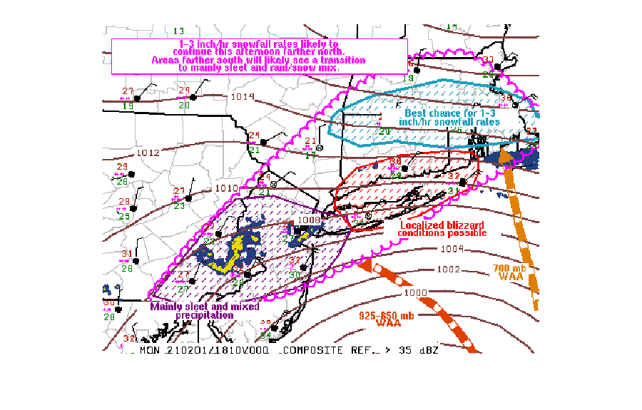
A band of extremely heavy snow has set up from the Philadelphia suburbs to New York City, across Long Island, and into southern New England, prompting the National Weather Service’s Storm Prediction Center (SPC) to issue a Mesoscale Discussion on the unfolding event.
According to the SPC, up to 2-“/hour snowfall rates will be possible across portions of the lower Hudson Valley and southern New England this afternoon, with occasional blizzard conditions possible across Long Island. While heavy snow continues there, portions of far eastern Pennsylvania into central New Jersey will continue to experience a heavy sleet/snow mix.
Right now, a surface low continues to gradually deepen while tracking slowly north-northeastward just off the Jersey Shore coast while a potent jetstream traverses the Mid Atlantic/New England Coastline. Strong warm-air advection ahead and north of the surface low continues to support ample mixed wintry precipitation and heavy snowfall potential amidst a sub-freezing atmospheric profile.
The latest RADAR from New Jersey in Fort Dix and New York in Brookhaven depicts an east to west snow/sleet transition zone roughly from Blue Bell, Pennsylvania to Islip, New York. Latest official observations also show a 1-3″/hour snowfall rate ongoing just north of this transition zone. The heavier snow/sleet area is expected to slowly progress north this afternoon.
The latest high-resolution, short-duration computer forecast models suggest that relatively lighter snowfall rates mixed with sleet will be the predominant precipitation type from far eastern Pennsylvania and central New Jersey southward this afternoon, with a transition of sleet likely across portions of Long Island.
Farther north across parts of southern New England, the heavier band of wintry precipitation will progress northward, with atmospheric conditions supporting 1-3″/hour snowfall rates this afternoon. According to the SPC, ” a few brief instances of 4″/hour rates also cannot be ruled out.”
These same high resolution models show the sleet falling across portions of New Jersey and Pennsylvania today turning back over to plain snow by tomorrow afternoon. While that happens, snow falling over southeastern New England will change to plain rain before changing back to moderate snow by Wednesday morning there. While the snow will end in the Mid Atlantic late Tuesday night, it should end across eastern New England by late Wednesday night.
