• Skip to primary navigation
  • Skip to main content
  • Skip to primary sidebar

Weatherboy

Weatherboy Weather News, Maps, RADAR, Satellite, and Forecasts.

  • Local
  • Earth Science News
  • RADAR
  • Current Warnings
  • Satellite
  • Current Maps
  • Forecast Maps
  • Video

Fire Weather Threat Impacts Western U.S.

by Weatherboy Team Meteorologist - September 9, 2020

A large portion of the western U.S. remains at risk for fire weather conditions. Image: NWS


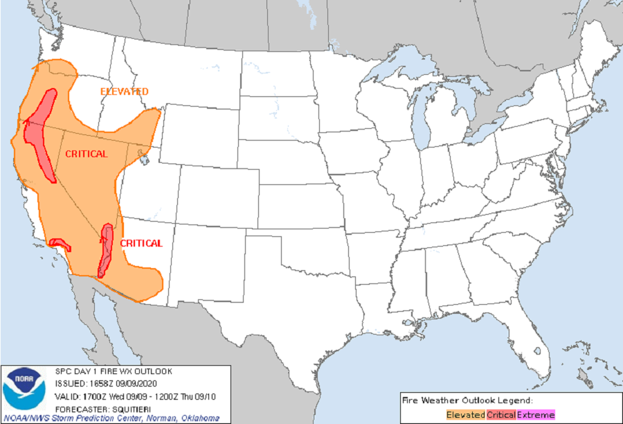
The same atmospheric set-up helping to bring significantly colder air and snow to a region that saw a 100 degree heatwave days ago is also helping fan fires along much of the western United States. In today’s Fire Weather Outlook from the National Weather Service’s Storm Prediction Center (SPC), large areas of California, Nevada, Oregon, Idaho, and Arizona are under an elevated or critical fire weather risk. An elevated risk of fire weather conditions also exists over southern Washington and northwestern Utah.

The SPC says that the strong offshore pressure gradient resulting from central Rockies high pressure and West Coast low pressure will remain in place much of the day, although a weakening trend will start later this evening as the high weakens and shifts eastward toward the central Plains. Meanwhile, subsidence aloft on the west side of a cutoff low over the Four Corners area will continue to maintain a very hot, dry airmass across much of the western states. The overall pattern will maintain widespread elevated fire weather conditions along with a few areas of critical fire weather near terrain-favored areas.


With humidities in the 7-15% range and winds in the 20-30 mph range with gusts to 45 mph, any flame could quickly spread in areas experiencing the fire weather conditions.

The GOES-West weather satellite captures the view of smoke streaming away from fires burning throughout the western states; some fires are large enough to show up as red pixels in this image.  Image: NOAA
The GOES-West weather satellite captures the view of smoke streaming away from fires burning throughout the western states; some fires are large enough to show up as red pixels in this image. Image: NOAA

Primary Sidebar

Sponsored Ad

Search

Latest News

  • NOAA Releases Hurricane Season Forecasts for Atlantic and Central Pacific Basins
  • Weak Morning Earthquake Rattles Maine
  • Nor’Easter Keeping Weather Cool and Damp in Northeast This Week
  • Miami’s National Hurricane Center Monitors Area for Cyclone Development
  • Scientists Unlock Climate Change Secrets: Say Ice Age Is Coming
  • Tornado Confirmed in New Jersey
  • National Hurricane Center Initiates Daily Reports Today
  • Severe Weather Likely Across Broad Area on Friday
About | Careers | Contact | Contests
Terms | Privacy | Ad Choices
Weatherboy is a (R) Registered Trademark of isarithm LLC, All Rights Reserved.
All content herein is Copyright by Isarithm LLC 1997-2022