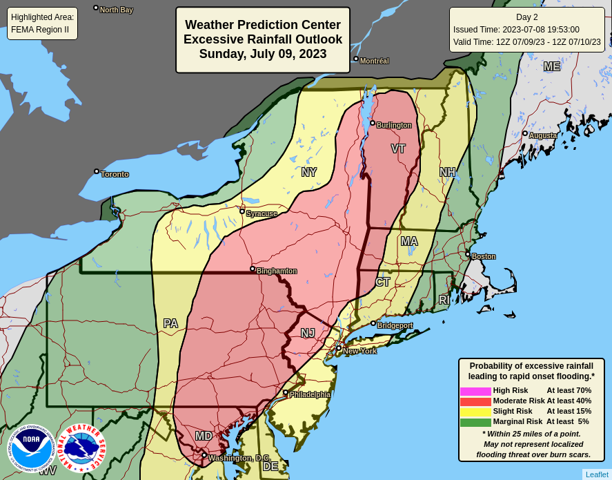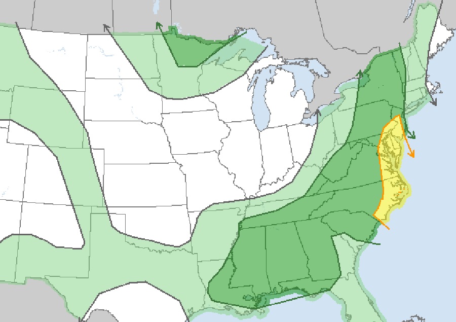
Severe thunderstorms and heavy rains are pushing into the eastern United States today, creating flooding problems. In the northeast from eastern Pennsylvania and northern New Jersey north up the Hudson Valley into central New England, the region is at the highest risk of excessive rainfall which could lead to rapid onset flooding. To the south, from central New Jersey south to the South/North Carolina border, the greatest threat of severe thunderstorms exists. Here, damaging wind is the primary threat from these severe storms although isolated damaging hail and tornadoes can’t be completely ruled out.
According to the National Weather Service’s Storm Prediction Center (SPC), recent satellite imagery shows a shortwave trough moving through the
central Appalachians; it is this system responsible for today’s rough weather. This shortwave is expected to continue east-northeastward throughout the day, interacting with the very moist air mass across the Mid-Atlantic region. Shear is relatively modest across northern portions of the region, with effective bulk shear around 30 to 35 kt. As a result, according to the SPC, predominantly multicellular storm mode is anticipated, with updraft duration likely limited by the lack of strong shear and storm interactions. Even so, some water-loaded downdrafts will likely appear, with the greatest threat around and near the Philadelphia metro area. Farther south across Virginia and into the Carolinas, a cluster of storms developed along a pre-frontal trough this morning across western North Carolina. Vertical shear over this area, particularly North Carolina, is a bit stronger and more westerly than areas farther north. This vertical shear will combine with ample low-level moisture and moderate buoyancy to support the persistence of this line as it moves east.
With heavy rain falling in the north and in isolated severe thunderstorms there, and severe thunderstorms more widespread to the south, the National Weather Service has been busy issuing assorted advisories and warnings due to the threats posed by Mother Nature today.

Currently, Flash Flood Warnings are in effect across portions of eastern Pennsylvania, southern New York, New Jersey, and Maryland, including the Baltimore metro area. Severe Thunderstorm Watches are also up for eastern Pennsylvania and New Jersey south to coastal North Carolina. Tornado Warnings are also occasionally issued for some storms, especially those moving through North Carolina.
Some severe weather may linger in the northeast tomorrow. According to the SPC, cool air aloft with a small ejecting shortwave trough will combine with 65-70 dewpoints and minimal heating to produce areas of rain and thunderstorms throughout the day in the northeast. This area of precipitation will shift northeastward with time, and the southern periphery near the New York City metro area could potentially harbor a few stronger cells as they will have access to stronger instability to southwest. That said, instability will be weak, as will shear, though winds will veer with height within the warm advection zone. Any rotation within storms is expected to be weak given aforementioned factors. While locally strong wind gusts may occur tomorrow, there shouldn’t be much of a tornado threat.