• Skip to primary navigation
  • Skip to main content
  • Skip to primary sidebar

Weatherboy

Weatherboy Weather News, Maps, RADAR, Satellite, and Forecasts.

  • Local
  • Earth Science News
  • RADAR
  • Current Warnings
  • Satellite
  • Current Maps
  • Forecast Maps
  • Video

Fred Brings Tornado, Flood Threat to Mid Atlantic Today

by Weatherboy Team Meteorologist - August 18, 2021

Severe thunderstorms are possible in the dark green and yellow areas today; the yellow area has the greatest threat of seeing severe storms. Image: weatherboy.com


The remnants of what was once Tropical Storm Fred are moving through portions of the Mid Atlantic today, threatening the region with heavy rain and severe thunderstorms; floods and tornadoes are possible.

The blue shaded area reflects where the greatest risk of tornadoes are today. Image: NWS

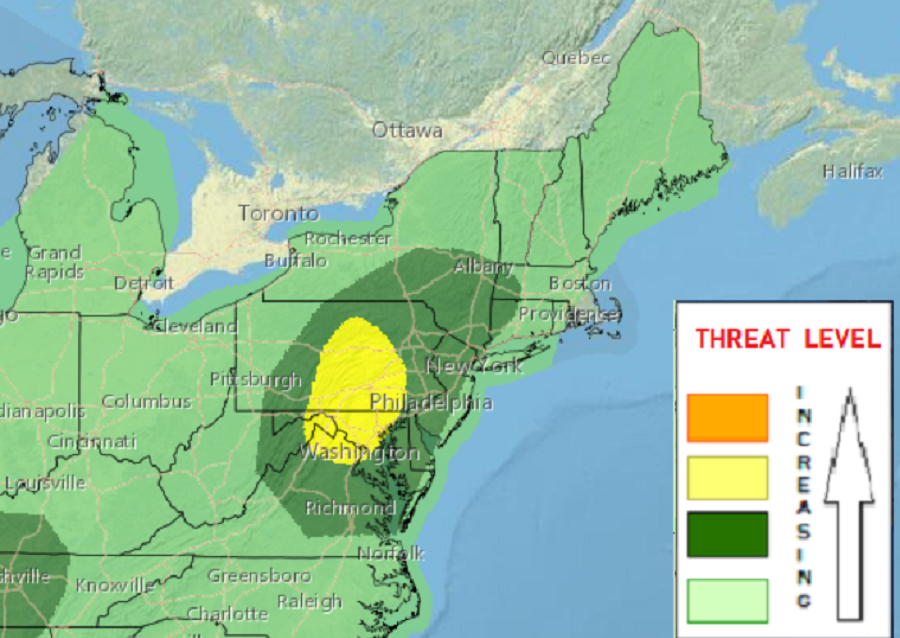
What’s left of Fred will move through northeastern Ohio, northern Pennsylvania, and upstate New York today  while continuing a gradual weakening trend. Nonetheless, a threat for tornadoes and damaging, isolated severe thunderstorm gusts will develop the next few hours, before weakening overnight tonight.

While the system will weaken, storms within it could still pack a punch. While not everyone will see a severe storm or tornado, they are possible, especially between 11 am and 4 pm today. Beyond isolated tornadoes, severe thunderstorms could produce damaging wind gusts and very heavy downpours. Hail isn’t likely from these storms at this time.


Current warnings.
Flood Watches, in dark green, reflect where the greatest chance of flooding rains will fall today. Image: weatherboy.com

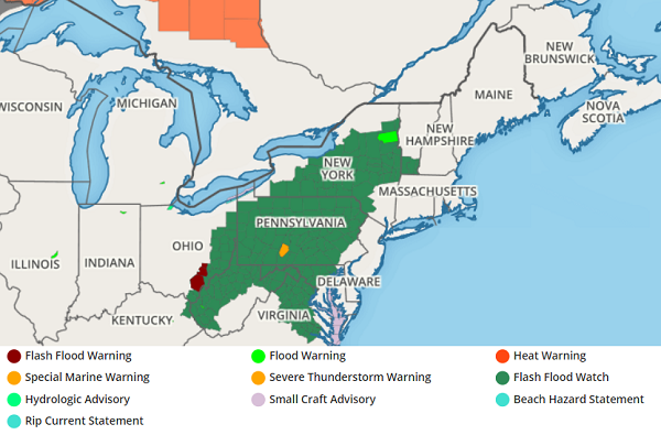
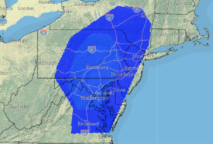
Beyond the severe weather threat, a threat of flooding also exists, prompting the National Weather Service to issue Flash Flood Watches for portions of Virginia, West Virginia, Ohio, Pennsylvania, Maryland, New York, and Vermont. Here, there could be widespread 2-4″ of rain, with 4-6″ possible near north central Pennsylvania and adjacent locations of Upstate New York over the next 48 hours.

While Fred’s remnants will move out of the northeast this week, eyes will turn to Henri. Henri is currently a tropical storm south of Bermuda, but it is forecast to intensify into a hurricane as it moves up and just off the U.S. East Coast. It is too early to tell whether or not Henri will make landfall on the U.S. East coast.


Primary Sidebar

Sponsored Ad

Search

Latest News

  • Sun Launches X-Class Solar Flare ; Severe Geomagnetic Storm on Earth Likely
  • Additional Snow Expected Over Northeast from Coastal Storm
  • Southeast Snow Likely Across Portions of Florida, Alabama, and Georgia on Sunday
  • Two Earthquakes Strike Alabama Northwest of Birmingham
  • Accumulating Snow Likely For I-95 Corridor; 3″+ Expected for Philly & New York City
  • Weak Earthquake Strikes Knoxville, Tennessee
  • Warnings Issued as Florida Freeze Approaches
  • Snow Possible in Florida This Weekend
About | Careers | Contact | Contests
Terms | Privacy | Ad Choices
Weatherboy is a (R) Registered Trademark of isarithm LLC, All Rights Reserved.
All content herein is Copyright by Isarithm LLC 1997-2022

Insert/edit link

Enter the destination URL

Or link to existing content

    No search term specified. Showing recent items. Search or use up and down arrow keys to select an item.