A very unusual weather pattern will bring a taste of winter to the northeast ahead of Mother’s Day. Freezing conditions and a widespread accumulating snowfall is possible; some areas may even see heavy accumulations of snow. Gusty winds could be another threat which may cause power problems too.
A variety of fast-moving weather features will help develop this unusual mid-May snow. A cold front will move into the Mid Atlantic later tonight into early Friday. An area of low pressure will develop along the boundary and track through the Ohio Valley on Friday, crossing the Mid-Atlantic, and moving off into the Canadian Maritimes on Saturday. As this system pushes east, it’ll have just enough moisture and just enough cold air to produce some snow in the northeast.
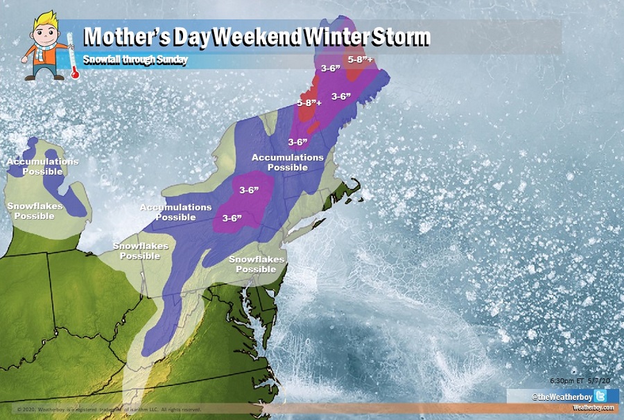
While snowflakes could fly at times, either on their own or mixed with rain, in locations like Philadelphia, New York City, and Boston, no snow accumulations are expected there at all. Just north and west of those cities, though, the snow could leave a light coating behind. However, because of temperatures and solar radiation at this time of year, any snow that does fall there won’t last long at all. In some higher locations of north central Pennsylvania and the central part of upstate New York, there could be isolated 3-6″ amounts of heavy, wet snow. Even there, the snow will not last very long. Across northern New England, 3-6″ or more of snow is possible; parts of the higher elevations of New Hampshire and north-central Maine could see 5″ or more of snow. Unlike the rest of the northeast, it could be cold enough for snow to linger for a bit in these areas. Most snow would fall late Friday into early Saturday.
High pressure will build across the southeastern states this weekend, moving off-shore on Sunday. This will help boot the winter weather system from the northeast into the Canadian Maritimes on Mother’s Day. As the weather system departs, winds will pick-up across southern New England and the Mid Atlantic states. Winds could reach advisory criteria in portions of New Jersey, Pennsylvania, and New York; some tree branches or power lines could snap, resulting in power failures there.
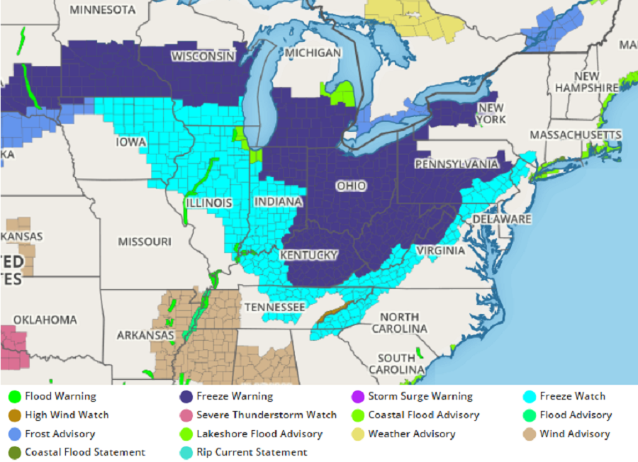
While temperatures will moderate once this storm system pushes through, they’ll be unusually cold with below-normal readings expected tonight through Sunday. Due to the cold air, the National Weather Service is issuing Frost and Freeze related watches and warnings for areas in the northeast for tonight, with more up for later Friday night into Saturday morning. Sensitive vegetation should be protected from the cold air, along with any outdoor plumbing.
Snow in early May is rare but not impossible. According to weather records, even New York City saw flurries on May 9 in 1977. On that same day, High Point, New Jersey saw a heavy, wet snow total of 10″. That storm, known as the “Mother’s Day Blizzard”, dropped 12.7″ in Worcester, Massachusetts, while 7.5″ fell in Providence, Rhode Island. Conditions could also be ripe for graupel to fall in central Pennsylvania, central New Jersey, and Long Island from this mid-May winter storm.
