It only takes a little bit of snow to create big problems, and that very scenario will play out at an unfortunate time in the heavily populated and well traveled I-95 corridor between Washington, DC and New York City, NY Friday evening.
A shortwave disturbance is forecast to dig around the backside of a large scale trough across the Midwest and Great Lakes region on Friday, setting the stage for a light snow event. Another weaker shortwave farther south will be tracking eastward into the central Appalachians. New data is suggesting that these two systems will phase a bit as they approach the Mid Atlantic region during the afternoon hours, with cyclogenesis expected near the North Carolina / Virginia border midday.
Atmospheric conditions ahead of the trough will likely lead to the development of light precipitation during the afternoon over coastal plain and possibly back into the I-95 corridor. Although temperatures in the coastal plain may be in the mid to upper 30s early in the afternoon, evaporative cooling should bring them down to the freezing point as precipitation arrives. As such, the precipitation type looks to be primarily snow for this event with the possibility
of a brief rain/snow mix at the onset near the coast.
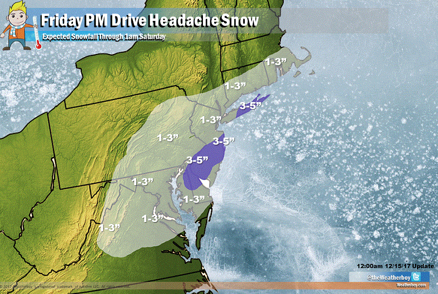
Because this system will be fast moving, snowfall accumulations won’t be too substantial. Similar to other recent light snow events, the most recent occurring Wednesday night, a broad area of 1-3″ snows are expected from Virginia to Massachusetts. Some mesoscale banding is possible over portions of Delaware, southern New Jersey, and eastern Long Island late Friday, which would lead to slightly heavier accumulations in the 3-4″ range. There’s also a chance that an isolated area may even pick up as much as 5″ of fluffy snow.
While the snow won’t be significant, the timing will be: snow will begin to fall from southwest to northeast along the I-95 corridor during the PM drive hours. It looks like the worst conditions may be from Baltimore to central New Jersey as it relates to prime driving time and snowfall. As a result, we expect a travel headache to blossom as snow falls as people try to head home or kick off weekend plans during the PM hours.
With temperatures plunging below well below freezing, any snow that falls on untreated surfaces will freeze and accumulate. Travel with extreme caution in this area; while the snow won’t be much, the impacts on travel will likely create many headaches.
