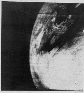
The GOES-R weather satellite is coming! Were you excited that moment before you were about to switch on your HDTV for the very first time? If you can remember that excitement and anticipation then you probably know what every meteorologist is feeling right now in North America. Well it’s not exactly happening in a mere moment but considering the black and white image shown here was taken from a satellite launched in 1960 to what images will soon be available from the new GOES-R satellite, in relative terms it is a moment.
GOES-R will be the newest and best weather satellite in the GOES series. GOES is short for Geostationary Operational Environmental Satellite. The GOES series has been in operation since 1975 and has continued to provide critical data for weather analysis and forecasting. GOES-R with be the first of the fourth generation of the GOES satellite and bring with it a number of new features along with enhancing the way we monitor the atmosphere.
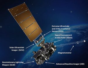
When most people think of the data made available by a weather satellite they may imagine it to just send back images of the clouds. Wide views of hurricanes or storm systems animated on your screens to show how the storms are developing and moving. While the first satellites did exactly that, GOES-R will be able to offer so much more. The new Advanced Baseline Imager is that primary instrument we all think of when we picture a weather satellite. This is what will capture the earth’s environment and weather. This is analyzed not only by what you see (visible) but also what you don’t see (infrared). In fact 16 channels are imaged and then analyzed to get a complete picture of the atmosphere and all that is contained in it, water vapor, clouds, dust and even volcanic ash.
It is not just what is being detected by the new satellite that is so impressive, but also how much and how fast that will be one of the biggest improvements. Imagine getting four times as much data five times faster than what you are used too. Higher resolution images and data will be available to both forecasters and researchers. This will undoubtedly lead to better forecasts along with increased warning times for all types of severe weather.
Along with the Imager is a lightning detector, a solar imager and technology to monitor space weather.
The launch date of GOES-R is set for early November. Until then we can just be amazed at how far we have come from the first TRITON satellite to where we are headed as we launch the new generation of weather satellite.
