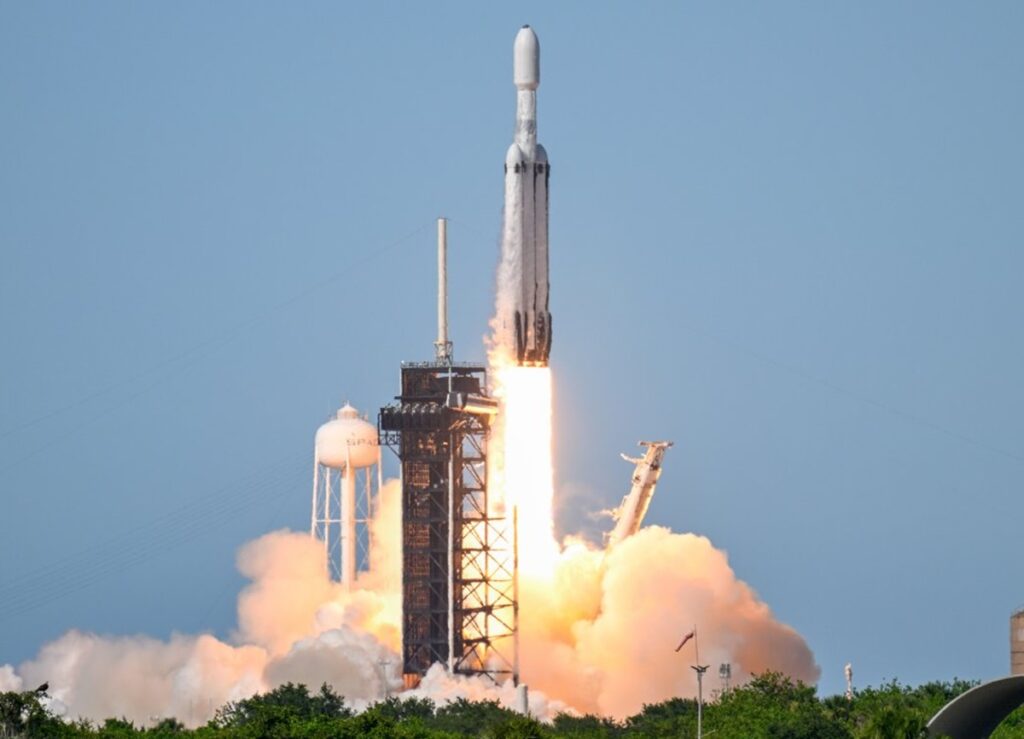
NOAA’s GOES-U weather satellite lifted off successfully into space this evening from NASA’s Kennedy Space Center and its Launch Pad 39A. Mounted atop a SpaceX Heavy rocket, the satellite began its journey to geostationary orbit after launching at 5:26 pm in Florida. The GOES-U weather satellite is the fourth and final of the GOES-R weather satellites NOAA created.
While GOES-U traveled to space, two of SpaceX’s side boosters used for the launch returned to Florida, landing at Landing Zones 1 and 2 at the Cape Canaveral Space Force Station roughly 8 minutes after left-off. Those rockets will be re-used by SpaceX for future space missions. The core booster used to lift the satellite into space was expended in space following separation with the rocket’s upper stage.
Today’s launch of a SpaceX Falcon Heavy rocket was its 10th, but it was the first time SpaceX carried a GOES weather satellite into space. The prior satellites used a United Launch Alliance Atlas 5 series rocket to bring the large and heavy piece of technology into geostationary orbit. The GOES series are roughly 20 feet by 18 feet by 12 feet and weigh about 6,300 pounds each.
Great to see weather satellites capture new weather satellites heading to space 🙂 #GOESU https://t.co/TfPhcviyyA
— the Weatherboy (@theWeatherboy) June 25, 2024
The satellite is now headed roughly 22,236 miles above the Earth’s surface. After it’s thoroughly checked-out there and activated, it will begin sending imagery and data down to meteorologists on Earth for additional analysis.
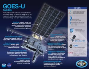
The GOES-R Series provides advanced imagery and atmospheric measurements, real-time mapping of lightning activity, and monitoring of space weather. GOES-U will be renamed GOES-19 after it reaches geostationary orbit. Following a successful on-orbit checkout of its instruments and systems, NOAA plans to put GOES-19 into operational service, replacing GOES-16 as GOES East. GOES-19 will work in tandem with GOES-18, NOAA’s GOES West satellite. Together, GOES East and GOES West watch over more than half the globe – from the west coast of Africa to New Zealand.
The Advanced Baseline Imager (ABI) is the primary instrument on the GOES-R Series satellites for imaging Earth’s weather, ocean and environment. Forecasters use ABI data for a wide range of applications related to severe weather, hurricanes, aviation, natural hazards, the atmosphere, ocean and cryosphere.
The Geostationary Lightning Mapper (GLM) is the first operational lightning mapper flown in geostationary orbit. Developing severe storms often exhibit a significant increase in lightning activity and GLM data can help forecasters focus on initial thunderstorm development and intensifying severe storms before they produce damaging winds, hail or even tornadoes.
GOES-U hosts a suite of instruments that improve the detection of approaching space weather hazards. The Solar Ultraviolet Imager (SUVI) and Extreme Ultraviolet and X-ray Irradiance Sensors (EXIS) provide imaging of the sun and detection of solar flares. The Compact Coronagraph-1 (CCOR-1) images the solar corona (outer layer of the sun’s atmosphere) to detect and characterize coronal mass ejections (CMEs). CCOR-1 is a new instrument for GOES-U and is part of NOAA’s Space Weather Follow On mission.
The Space Environment In-Situ Suite (SEISS) and Magnetometer monitor, respectively, energetic particles and the magnetic field variations that are associated with space weather. Together, observations from these instruments contribute to space weather forecasts and early warning of disruptions to power utilities and communication and navigation systems as well as radiation damage to orbiting satellites.
