
The greatest threat for tornadoes on Saturday in the U.S. will be in New Jersey and Delaware, with a focus on the Jersey Shore and the Delaware Beaches where waterspouts will be possible too. This assessment is based on the latest Convective Outlook issued by the National Weather Service’s Storm Prediction Center (SPC.)
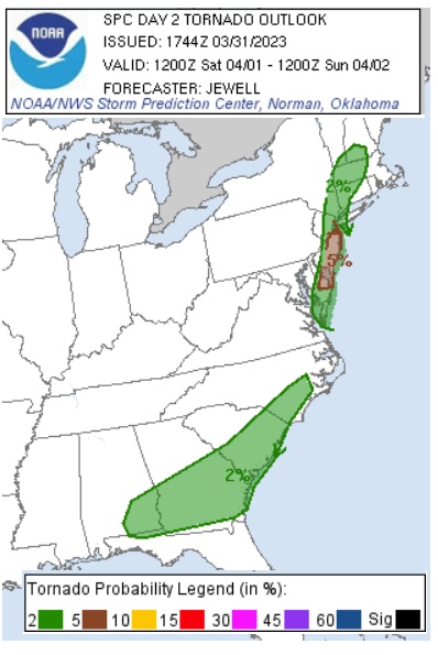
As a weather system responsible for violent tornadoes today and damaging winds early tomorrow into Sunday pushes east, atmospheric ingredients may be ripe to produce tornadoes across portions of the eastern United States. According to the SPC, there is an elevated risk of tornadoes from southwestern New Hampshire and extreme southern Vermont into western Massachussetts, southeastern New York, western Connecticut, much of New Jersey and Delaware, and northeast coastal Virginia. There is also an elevated risk of tornadoes from southeastern Alabama into southern Georgia and South Carolina up into the southeast coast of North Carolina.
However, within this area, over portions of central and southern New Jersey and much of Delaware, there is an even more elevated risk of tornadic cells, according to the SPC.
A large shortwave-trough will move across the Upper Great Lakes and Ohio Valley to the Mid Atlantic, with substantial height falls and cooling aloft overspreading into the East the entire region. The SPC says that an intense leading midlevel jet streak will approach the Appalachians by midday, with a secondary cold pocket and vorticity max aloft affecting the I-95 corridor late in the day. To the south, moderate westerlies aloft will exist over the Southeast, as the influence of the upper trough grazes the area.
At the surface, low pressure should gradually deepen as it moves east/northeast from southwest Ontario toward northern Maine. Extending east of the low track will be a developing warm front which will
bring 50s F dewpoints into southern Vermont and New Hampshire.
Although the primary surface low will move toward more stable areas to the north, a prominent surface trough will develop southward coincident with the secondary vorticity max moving rapidly east. While various regimes of severe weather may occur with these features, this secondary wave will affect the Mid Atlantic late in the day and into early evening, and is expected to result in wind damage from
western Massachussetts and Connecticut into far eastern Pennsylvania, all of New Jersey, and parts of the Delmarva.
It is in this area over New Jersey and Delaware where a few tornadoes may occur as these storms move through in this environment.
Southerly surface winds for most of the day will help deepen the moist boundary layer, with a plume of upper 50s F to near 60 F dewpoints from eastern Virginia northward across Philadelphia and into far southeast New York. Strong heating will occur along and west of this moist plume, priming the air mass for the arrival of an intense cold front arrive very late in the day and into early evening for eastern areas. The SPC says that forecast soundings reveal supercell wind profiles ripe for violent weather. The forecast is for storms to form in the moist axis as the front rapidly intercepts the moist air mass, with rapid changes taking place aloft. Some of these storms could develop along coastal counties as well, and at least isolated supercells are expected. In addition to the tornado risk, the threat of damaging winds will be quite likely with any strong convection given 55 mph winds or greater out of the northwest just off the surface.
Waterspouts are also possible on near-shore waters and bays and these waterspouts could evolve into tornadoes as they cross barrier island communities, especially at the Jersey Shore. Boaters should also be aware of this threat that exists tomorrow.
Farther south, a front/dryline will slow as it moves into southern Alabama and across Georgia during the day, with a more substantial cold front pushing east across Virginia and the Carolinas. Scattered severe storms are possible across these areas during the day.
People in these high risk tornado zones should determine where they’ll be during the PM hours and plan out what they’d do or where they’d go should a Tornado Warning be issued for their community. While Severe Thunderstorm or Tornado Watches may be issued a few hours ahead of the arrival of the threat, Tornado Warnings and Severe Thunderstorm Warnings may only be issued seconds or minutes before impact.
