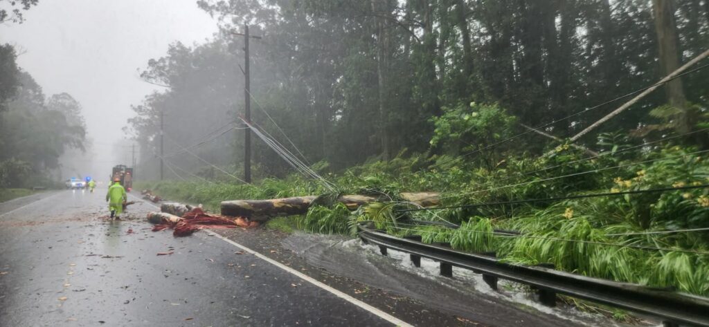
The deadly and destructive Lala, once a hurricane, continues to weaken and head west, allowing recovery efforts to begin on the islands from east to west. The first to be impacted by the storm was the Big Island of Hawaii, which was hit by the hurricane’s eyewall yesterday evening near South Point in the Kau district of Hawaii Island. While casualty and damage reports are compiled, authorities have confirmed at least one death and many injuries from the storm in Hawaii.
While the eye of the hurricane stayed off-shore just off the south coast of the Big Island of Hawaii, powerful winds blasted the entire Big Island and much of the state. High winds were recorded at numerous sites on the Big Island: 84 mph at Kohala Ranch, 78 mph at Kona International Airport, 72 mph at Manuka, 72 mph at Kawaihae, 66 mph at Waikoloa, 62 mph at Waimea, and 60 mph at Waikoloa Beach Resort. The other islands also had high winds: 74 mph at Oahu Forrest on Oahu, 67 mph at Kuakala, Oahu, 85 mph at Olowalu, Maui, 70 mph at Ilio, Maui, and 63 mph at Puaahala, Maui.
Rainfall amounts were extreme too and varied widely due to the significant changes in geography around the volcanic islands. The southeastern portion of the Big Island saw 2-3 feet of rain, while areas around Hilo saw 6-12″. In the higher terrain above Hilo on the slopes of Mauna Kea, more than 2 feet of rain fell. On the west side of the island, much less fell with 1-3″ recorded around Kona.
Currently, Lala was downgraded to a Tropical Storm but is forecast to become a hurricane again as it moves away from the State of Hawaii. In the latest advisory issued by the Central Pacific Hurricane Center, Lala was located at 20.9 N 160.0W which is about 275 miles west-northwest of Kailua-Kona on the Big Island of Hawaii and about 140 miles west of Honolulu on the island of Oahu. Maximum sustained winds were at 65 mph while the minimum central pressure was at 994 mb or 29.36″. The storm is moving to the west-northwest at 16 mph.
A Tropical Storm Warning remains in effect for Maui County, including the islands of Maui, Lanai, Molokai and Kahoolawe, Oahu, and Kauai County, including the islands of Kauai and Niihau. A Tropical Storm Warning means that tropical storm conditions are expected somewhere within the warning area, in this case within the next 6 to 12 hours.

Lala is forecast to move west through Tuesday night, followed by a turn toward the west-northwest on Wednesday. Little intensity change is expected through Monday. Some restrengthening is forecast thereafter, and Lala could become a hurricane again on Tuesday or Wednesday.
Wind and rain threats will continue to impact the islands, mainly from Maui west.
Tropical storm wind conditions, especially in gusts, are ongoing across portions of Maui County, Oahu, and Kauai County, with the strongest winds occurring in areas of higher terrain. Wind speeds atop mountains and on the windward and leeward slopes are often up to 30 percent stronger than the near-surface winds and in some elevated locations could be even greater.
The outer bands from Lala are expected to produce additional rainfall of 1 to 2 inches across windward portions of the Big Island and windward Maui, with maximum storm totals of 30 to 40 inches over the windward Big Island. Across the remainder of the island chain an additional 2 to 4 inches of rainfall is expected, with isolated additional totals around 6 inches. According to the National Weather Service, this rainfall may produce flooding and mudslides, especially in areas of steep terrain.
Surf around the state also remains problematic. Swells generated by Lala will continue to build westward across the exposed windward waters today. Swells will also build over the exposed leeward waters as Lala passes south of the islands. These swells are likely to cause life-threatening surf and rip current conditions for several days.
