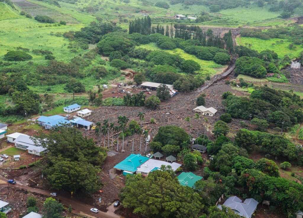
Hurricane Lala brought incredible destruction across portions of Hawaii’s Big Island; an overflight by Hawaii Governor Josh Green yesterday provided insight in the magnitude of the damage there.
Inside the Ka‘ū District of the Big Island, on the south side of Hawaii Island, are/were the communities of Pāhala, Waiʻōhinu, and Nāʻālehu, each of which took on catastrophic conditions: homes and businesses washed away, roadways and electrical lines gone, and even cemeteries fell victim to rock and mudslides, floating caskets and human remains into local streets.

Perhaps the most famous business in the district is the Punalu‘u Bake Shop, which was destroyed by the heavy rain and resulting mud and rock flows that tore through the southernmost bakery in the United States. The world-famous bakery was not only famous for their Hawaiian sweet breads and rolls, but for their fresh malasadas, turnovers, eclairs, and pastries baked every day. For those visiting the Hawaii Volcanoes National Park and the stunning Kilauea Volcano there, a stop at the bake shop was a must: enjoying a fresh sandwich, a cup of fresh brewed Ka‘ū coffee, or indulging in an afternoon ice cream treat was part of the Big Island vacation experience.
Zachary Kennedy, General Manager of the bake shop, released a statement and video from the rubble of his business. “I know this is a hard time for everyone in our community and across our islands. But the most important thing is that people are okay. Buildings can be rebuilt. Roads can be repaved. Trees can be planted again. The most precious thing is human life,” Kennedy said.
“We at the bakery are grateful to know that most of our employees are safe and healthy, along with their families. It will take time, and we are currently assessing the damage properly. We will be back. We will be stronger,” Kennedy added.
Overall, more than 100 homes in Hawaii were damaged and destroyed and roughly 200,000 customers across the state lost electricity during the storm; HECO, the electrical utility on the Big Island of Hawaii, said service may not be restored for weeks in some parts of their service area.
On the Big Island, one death was blamed on the storm. A 98 year old Nāʻālehu resident, a former school teacher at the Nāʻālehu Elementary School, was found deceased in the rubble. While the county feels fortunate that so far there has been only one death related to the hurricane, Hawaiʻi County Mayor Kimo Alameda said: “Any loss is devastating.”
On Oahu, lifeguards reported making 59 water rescues from people stuck in the hurricane’s swells.
On Kauai and Maui, significant flood and wind damage also occurred with countless trees toppled and many communities encountering flood damage. Even on the outer islands away from Hawaii Island, many remain in the dark with no electrical service and no internet access.
The Hawaii National Guard and the U.S. Coast Guard have deployed troops to the flood-stricken areas of Hawaii to conduct search and rescue operations.
Hurricane Lala weakened to a Tropical Storm after moving away from Hawaii’s Big Island but continued to lash the rest of the islands of the state with heavy rain and strong winds. The storm moved north and west away from Hawaii and re-intensified into a hurricane today.
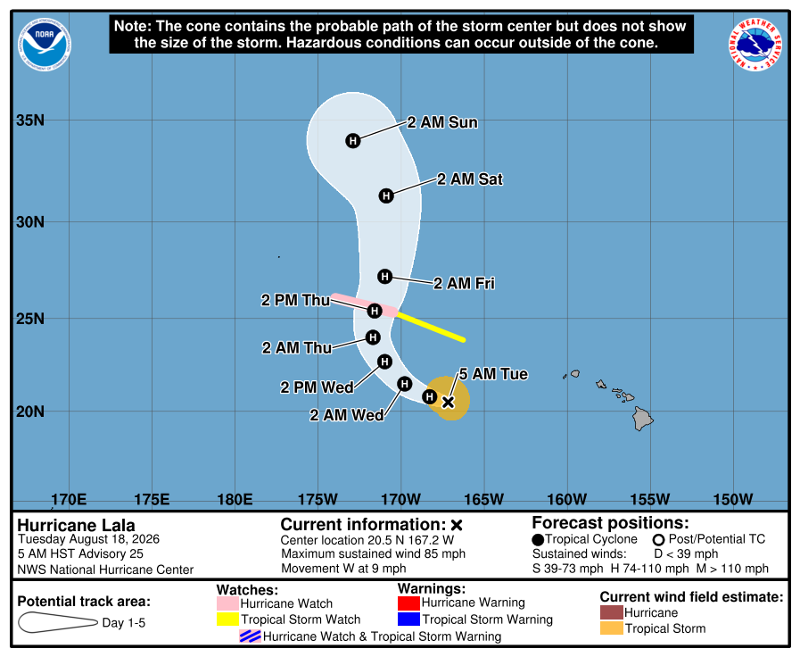
Now, Hurricane Lala is about 390 miles south-southeast of Maro Reef and about 580 miles southeast of Lisianski Island. With the storm headed their way, a Hurricane Watch has been issued for the Papahanaumokuakea Marine
National Monument from Lisianski Island to Maro Reef. A Tropical Storm Watch is now in effect from the Papahanaumokuakea Marine National Monument east of Maro Reef to French Frigate Shoals.
A Hurricane Watch means that hurricane conditions are possible within the watch area. A watch is typically issued 48 hours before the anticipated first occurrence of tropical-storm-force winds, conditions that make outside preparations difficult or dangerous.
A Tropical Storm Watch means that tropical storm conditions are possible within the watch area, generally within 48 hours.
“Interests elsewhere in the Papahanaumokuakea Marine National Monument should monitor the progress of Lala. Warnings may be require for portions of this area later today,” says the National Hurricane Center.
For now, Lala is moving toward the west near 9 mph and this motion is expected to continue today. A turn toward the west-northwest then northwest is forecast tonight and Wednesday, followed by a turn toward the north on Thursday.
Maximum sustained winds are now near 85 mph with higher gusts. Strengthening is forecast during the next day or so, and Lala is expected to remain a hurricane for the next several days.
Hurricane conditions are possible in the Hurricane Watch area by Thursday, with tropical storm conditions possible by Wednesday night. Tropical storm conditions are possible in the Tropical Storm Watch area by Thursday.
Large surf associated with Lala will affect the Papahanaumokuakea Marine National Monument beginning early Wednesday. These large waves will likely inundate some of the low-lying atolls, especially from French Frigate Shoals to Maro Reef.
