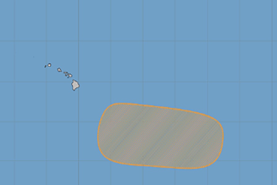
While residents and visitors of Hawaii deal with the aftermath of Hurricane Lala, meteorologists at the National Hurricane Center and the Central Pacific Hurricane Center are keeping a watchful eye on an area of disturbed weather south and east of Hawaii in the tropics.
According to the Central Pacific Hurricane Center (CPHC), a broad area of low pressure could form well to the southeast of the Hawaiian Islands during the middle to latter part of the week.
“Environmental conditions appear conducive for gradual development of this system, and a tropical depression could form towards the end of the week and into the weekend, while the system moves generally westward across the western portion of the east Pacific and into the central Pacific,” cautions the CPHC in their latest Tropical Outlook issued today.
While a tropical depression could form, current computer forecast guidance doesn’t think it’ll take-off and grow the way Hurricane Lala recently did. Both the American GFS and European ECMWF, as well as the AI-based Google DeepMind model, suggest the storm may fizzle before it becomes too much of a problem for Hawaii. Lingering moisture from the remnants of it, though, could bring heavy rain to Hawaii in time.
That same computer forecast guidance suggests there could be a more substantial storm beyond this one, but because it is so far into the future, meteorologists don’t put too much confidence in such an extended forecast in the tropics.
The Central Pacific Hurricane Season started on June 1 and continues through the end of November. Due to the presence of a significant El Nino event, meteorologists believe a hyperactive hurricane season will continue for the basin.
The most recent forecast from the NOAA Climate Prediction Center indicates El Niño conditions are expected throughout the hurricane season. The ENSO influence on eastern and central Pacific hurricane activity is highly dependent upon the background sea surface temperature (SST) patterns across the eastern tropical Pacific and the Atlantic hurricane Main Development Region (MDR). For 2026, the tropical Pacific is most likely to experience a moderate or stronger El Niño. The El Niño conditions and lack of strong forcings (SSTs near normal) in the Atlantic are likely to support higher levels of activity in the East Pacific. Strong El Niño conditions are typically associated with dramatically elevated levels of activity in the central Pacific.
NOAA also says the latest monthly SST anomalies reflect ENSO-neutral conditions, a negative Pacific Decadal Oscillation (PDO) structure, and North Atlantic SSTs just slightly above-normal for much of the basin. The transition to El Niño will likely shift the projection onto the PDO toward zero or even into positive PDO territory. Historically, this combination has resulted in more tropical cyclone activity for the eastern and central Pacific.
At the National Tropical Weather Conference on South Padre Island, Texas in April, hurricane experts gathered to discuss the upcoming hurricane season. While the focus was on the Atlantic Hurricane Basin, where there was a collective sigh of relief that the Atlantic may see a below-normal hurricane season, there were concerns that the inverse may be true in the Pacific where Hawaii could be a sitting duck for an active season.
“We anticipate that the 2026 Atlantic basin hurricane season will have somewhat below normal activity,” the official CSU outlook states. “Current weak La Niña conditions are likely to transition to El Niño in the next few months, with the potential for a moderate/strong El Niño for the peak of hurricane season,” they add.
Dr. Phil Klotzbach said NOAA forecasters say there is a 90% chance of an El Nino event during the peak of hurricane season.
ENSO, short for El Nino Southern Oscillation, is a recurring climate pattern involving changes in the temperature of waters in the central and eastern tropical Pacific Ocean. On periods ranging from about three to seven years, the surface waters across a large swath of the tropical Pacific Ocean warm or cool by anywhere from 1°C to 3°C, compared to normal. This oscillating warming and cooling pattern, referred to as the ENSO cycle, directly affects rainfall distribution in the tropics and can have a strong influence on weather across the United States and other parts of the world. El Niño and La Niña are the extreme phases of the ENSO cycle; between these two phases is a third phase called ENSO-neutral. While this phenomena impacts the entire United States, Hawaii may find itself particularly vulnerable this year to bad weather conditions.
Dr. Phil Klotzbach said Hawaii is a relatively small chain of islands in a very large ocean at today’s seasonal outlook unveiling. He added that even with an active season, because the basin is so large and the islands are relatively small, it’s possible even an active season in the Central Pacific could lead to no or a low number of landfalls.
Deputy Director of the National Hurricane Center, Jaime Rhome, urged caution for Hawaii. “Usually when the Atlantic is quiet, the Pacific perks up.”
The CSU forecasters say, “As with all hurricane seasons, coastal residents are reminded that it only takes one hurricane making landfall to make it an active season. Thorough preparations should be made every season, regardless of predicted activity.”
“Although El Niño’s impact in the Atlantic Basin can often suppress hurricane development, there is still uncertainty in how each season will unfold,” said NOAA’s National Weather Service Director Ken Graham. “That is why it’s essential to review your hurricane preparedness plan now. It only takes one storm to make for a very bad season.”
“Our geography makes preparedness even more important because we are the most isolated populated landmass on the planet here,” said Hawaii Governor Josh Green. “If we ever had a severe hurricane come and take out our harbor, we would be on our own for a while, and so that’s why you have to be prepared.”
“Preparing now for hurricane season — and not waiting for a storm to threaten — is essential for staying ahead of any storm. Visit weather.gov/safety and Ready.gov for important preparedness information,” added Graham.
