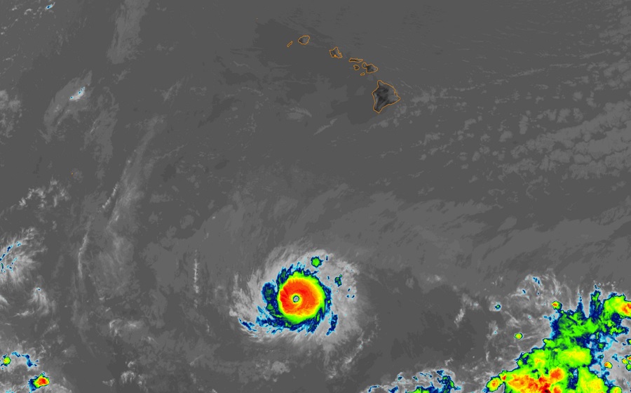
Major Hurricane Dora, a category 4 hurricane with 130 mph winds, passed well south of Hawaii’s Big Island, but a significant pressure difference between it and a high pressure north of the islands set the stage for a severe wind and fire weather event in the Aloha State. Damaging winds have knocked down trees and powerlines while those same winds are helping to fan several fires on Hawaii’s Big Island and the island of Maui.
According to the National Weather Service, “fire weather” is the use of meteorological parameters such as relative humidity, wind speed and direction, mixing heights, and soil moisture to determine whether conditions are favorable for fire growth and smoke dispersion. Based on the analysis by meteorologists at the Honolulu office of the National Weather Service, Red Flag Warnings, indicating the presence of fire weather risks, have been issued for for large parts of each island, especially the western/leeward side areas which could be influenced the most by downslope flows.

Yesterday, National Weather Service meteorologist John Bravender, who serves as the Warning Coordination Meteorologist for the Honolulu office, wrote in a forecast discussion that forecast soundings show a crashing inversion height, down below 3,000 feet and precipitable waters dropping to less than one inch, which is more than a standard deviation below normal for this time of year. The combination of strong winds and strengthening/lowering inversion to compress/accelerate the winds between inversion and terrain will lead to damaging trade winds.
Those damaging winds materialized last night and remain over many portions of the Hawaiian Islands today, where High Wind Warnings remain in effect until 6 am Wednesday, local time. East winds of 30 to 45 mph sustained with localized gusts to around 60 mph continue to lash the islands.
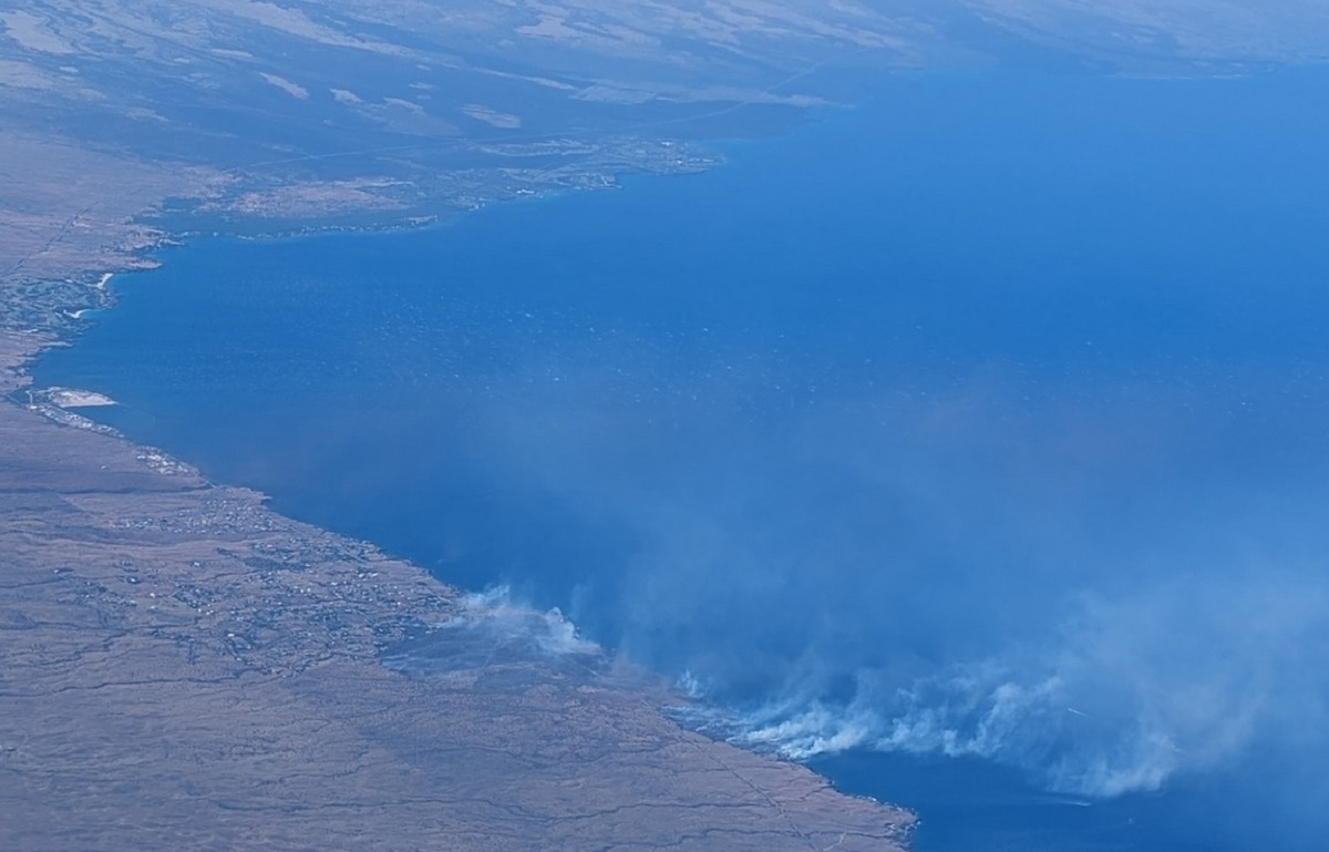
On the Big Island of Hawaii, people in Kohala Ranch, Kohala by the Sea, Kohala Waterfront, and Kohala Estates are being asked to evacuate by Hawaii Fire Department. According to Hawaii County Civil Defense, evacuation shelters have been opened in North Kohala at the Hisaoka Gym in Kapaau and in Waimea at the Waimea Community Center. Hawaii County Civil Defense is also tracking a brush fire near the Lalamilo subdivision within Waimea, which as of press time, has been restricted within containment lines in the community. There are no fires in the Waikoloa Beach, Mauna Lani, Hapuna, and Mauna Kea Beach communities at this time, but roads north of that resort corridor are closed except for evacuating traffic and emergency responders.
Fire Weather conditions and active fires on the west coast of Hawaii’s Big Island is prompting the evacuation of several residential areas. #HIwx https://t.co/HxRUiIKoFQ
— the Weatherboy (@theWeatherboy) August 8, 2023
Large fires are also burning on the island of Maui, where Maui County Emergency Management officials are warning people to “grab your ‘go kits” and evacuate your family and pets now” near King Kaulike High School. The Hannibal Tavares Community Center has been opened to shelter people there.

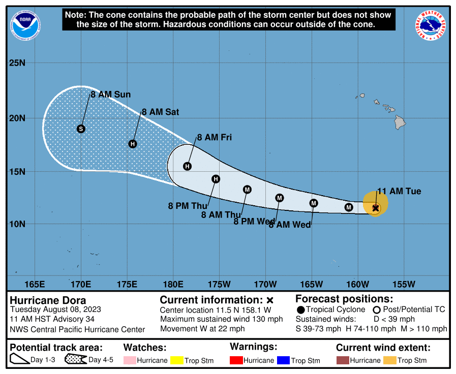
High winds will persist into tomorrow morning as Hurricane Dora heads west across the Pacific. As of the latest advisory from the Central Pacific Hurricane Center (CPHC), Dora was located about 675 miles south of Honolulu, Hawaii and about 845 miles east-south-east of Johnston Island. The storm, packing winds of 130 mph and pressure down to 953 mb or 28.15″, is moving to the west at 22 mph.

The CPHC is forecasting Dora to remain as a major hurricane with winds greater than 110 mph at least through Thursday evening and slowly weaken, eventually becoming a tropical storm by Sunday morning well west of Hawaii.
Swells generated by Dora are expected to begin impacting Johnston Island late Wednesday, likely producing large and life-threatening surf through Thursday. High surf is already impacting the east facing shores of the Big Island, Maui, and Molokai, where a High Surf Warning is in effect. Dangerously large breaking waves of 10-15 feet are impacting these coastlines. Waves breaking in channel entrances may also make navigating the channels very dangerous. The National Weather Service cautions, “Stay away from the shoreline along affected coasts. Be prepared for road closures. Postpone entering or leaving channels affected by the high surf until the surf subsides.”