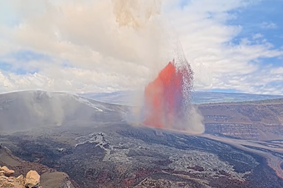
The Kilauea Volcano on the Big Island of Hawaii has erupted today, beginning its 49th episode since this latest eruption series started in December 2024. The event began at 9:36 am local time and the National Weather Service in Honolulu on the Hawaiian Island of Oahu has issued a Special Weather Statement cautioning people on the Big Island about the possibility of a light ashfall. With the eruption under way, USGS has raised the Volcano Alert Level and Aviation Color Code for the volcano.
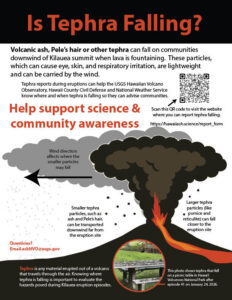
According to USGS, ground-level sensors near the eruptive vents indicate that winds are blowing from the north northeast direction, which suggests that lower level volcanic gas emissions and volcanic material may be distributed to the southwest direction from Halemaʻumaʻu located at the summit crater. USGS says that ash dispersion models for episode 49 fountain-related ash clouds currently suggest most tephra fall will be to the southwest of the vents, though nearby communities to the north of Kīlaueaʻs summit may experience trace tephra and/or ash-Peleʻs hair fall.
The National Weather Service issued a Special Weather Statement shortly after the start of the eruption. They write, “The latest radar imagery shows the highest detectable ashfall (tephra) from the lava fountaining is currently rising to around 10,000 feet above ground level this morning. Low level trade winds continue to push the ashfall particles toward the southwest direction on radar, and any additional ash from this eruption will likely fall near the Kilauea eruption source and over portions of the Kau District immediately southwest of Halemaumau Crater.”
Due to the eruption, the National Weather Service warns people to avoid excessive exposure to volcanic ash, which is an eye and respiratory irritant. “Those with respiratory sensitivities should take extra precaution to minimize exposure,” the National Weather Service added.
During the 2018 eruption of Kilauea, the National Weather Service in Honolulu created special products to keep the public informed of the risks posed by the possible ashfall from Hawaii’s most active volcano. . NOAA meteorologist John Bravender, who works at the Honolulu office of the National Weather Service, told us then how they’ve developed the advisories.
“The volcanic ashfall program is something we’ve been working on quite fast over the past week or two. As the weather forecast office, we’ve had responsibility for issuing SIGMET and aviation warnings but given the past history from our volcanoes, haven’t really been really concerned about ashfall. ” Bravender said the team there has had a “crash course” of sorts to develop a program, relying on experts from other groups such as Hawaiian Volcano Observatory (HVO) and the Alaska Aviation Weather Unit. But unlike severe weather watches that are issued ahead of other severe weather events, you won’t see an Ashfall Watch posted. “There’s no watches; these are very reactive products, ” Bravender told us.
When an ashfall incident is imminent due to some type of explosion at the volcano, the National Weather Service office in Honolulu will issue one of three types of products. The first is a Special Weather Statement. A Special Weather Statement is issued when there is the potential for trace amounts of accumulating ash. When there’s a chance of a more significant ashfall, from over a trace to up to 1/4″, the National Weather Service will then issue an Ashfall Advisory. And if a heavy ashfall is expected with accumulations greater than 1/4″, an Ashfall Warning is issued.
When any of these products are issued, the National Weather Service encourages people to avoid ash. “Avoid excessive exposure to ash which is an eye and respiratory irritant,” the Special Weather Statement text reads. “Those with respiratory sensitivities should take extra precaution to minimize exposure.”
USGS has raised the alert level/aviation color code at the volcano to WATCH/ORANGE. In the U.S., the USGS and volcano observatory units are responsible for issuing Aviation Codes and Volcanic Activity Alert Levels. Aviation Codes are green, yellow, orange, or red. When ground-based instrumentation is insufficient to establish that a volcano is at a typical background level of activity, it is simply “unassigned.” While green means typical activity associated with a non-eruptive state, yellow means a volcano is exhibiting signs of elevated unrest above known background levels. When a volcano exhibits heightened or escalating unrest with the increased potential of eruption, it jumps to orange. Finally, when an eruption is imminent with significant emission of volcanic ash expected in the atmosphere or an eruption is underway with significant emission of volcanic ash into the atmosphere, the code becomes red. Volcanic Activity Alert levels are normal, advisory, watch, or warning. As with aviation codes, if data is insufficient, it is simply labeled as “unassigned.” When the volcano is at typical background activity in a non-eruptive state, it is considered normal. If the volcano exhibits signs of elevated unrest above background level, an advisory is issued. If a volcano exhibits heightened or escalating unrest, a watch is issued while a warning is issued when a hazardous eruption is imminent.
Because the eruption is contained within a National Park and there’s no imminent danger to those outside of it, it is unlikely USGS will issue a Warning at this time.
Kilauea has been erupting episodically since December 23, 2024 from two vents in Halema‘uma‘u. Lava fountaining episodes, which generally last for less than 12 hours, are separated by pauses that can be longer than three weeks. The current eruption is the longest eruption on record for Kilauea.
