A disturbance is forecast to move through portions of the Northeast and Mid Atlantic tomorrow morning, triggering snow showers and heavier snow squalls. Because these snow showers will unfold near the I-95 corridor between Philadelphia and New York during the morning commute time, the National Weather Service is expressing concern for potentially hazardous driving conditions in and around these cities and New Jersey and Delaware.
This morning, an area of lake effect and lake enhanced snow showers developed and intensified across central Pennsylvania; this disturbance was associated with a surface trough and a weak mid level short
wave. This disturbance could trigger another stray snow shower or flurry over the region as gusty northwest winds of up to 20-30 mph move through.
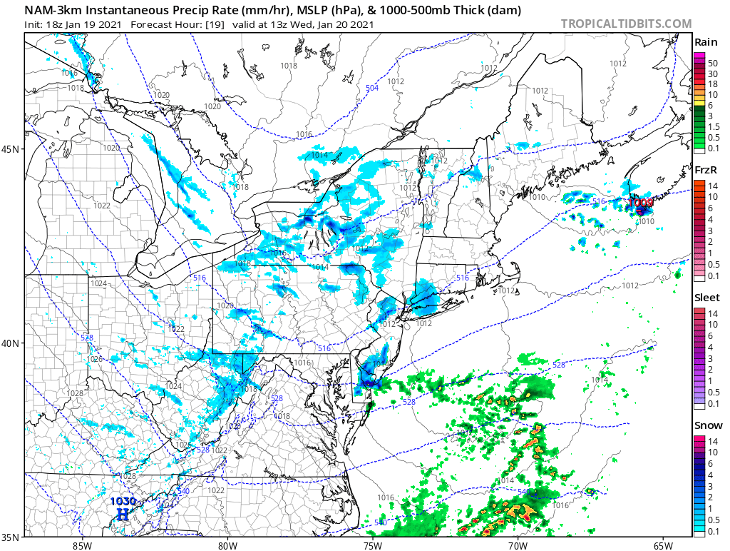
A mid-level trough digging on the back side of today’s low will slide into the Mid Atlantic later tonight into Wednesday morning. While the system will be starved for moisture, there could be just enough moisture and energy to set off not only a round of snow showers and snow flurries, but a snow squall or two too.
A snow squall is a sudden moderate to heavy burst of snow that typically is joined by strong, gusty winds which in turns blows that falling snow. Snow squalls can create white-out conditions similar to a blizzard, but a snow squall is extremely localized in time and location. Squalls can form over portions of towns and can move in and out in a period of minutes rather than hours.
The greatest threat of snow squalls will be from 5am to 11am as they march east across Pennsylvania and New York into New Jersey and Delaware during the morning hours. The Mount Holly, New Jersey office of the National Weather Service, responsible for the forecast area where most squalls and showers could form, says, “Like with summer storms, not everyone will see them, but stay alert if you’ll be out tomorrow morning!” They add that the most likely timing of the squalls overlaps with the morning commute time.
Snow squalls could quickly coat the ground and untreated surfaces, making travel very slippery very quickly. Beyond that, though, no significant accumulations of snow are expected at all from this event.
The threat of snow flurries, showers, and squalls will clear the coast by lunchtime, with fair and dry weather returning for the balance of the day.
