• Skip to primary navigation
  • Skip to main content
  • Skip to primary sidebar

Weatherboy

Weatherboy Weather News, Maps, RADAR, Satellite, and Forecasts.

  • Local
  • Earth Science News
  • RADAR
  • Current Warnings
  • Satellite
  • Current Maps
  • Forecast Maps
  • Video

Heavy Rain to Impact Mid Atlantic

by Weatherboy Team Meteorologist - July 27, 2017

Heavy rain is forecast to return to the eastern United States as the week comes to a close.

After a quiet but brief dry weather period in portions of the Mid Atlantic the last two days, a new potent storm is expected to arrive and bring with it very heavy rain.  While showers and storms will move into portions of the Mid Atlantic later today, the best chance of heavy rainfall will be from Friday afternoon through to Saturday afternoon. The heaviest rain is expected over New Jersey, Pennsylvania, Maryland, and Delaware.

Areas that were impacted by heavy rainfall earlier this week will be particularly vulnerable to another round of flash flooding. Additionally, a few thunderstorms may become severe with
the primary threat being damaging winds. It now appears this system will move a bit slower than originally thought; rather than clearing out for early Saturday morning, clouds and showers may linger for a good part of the day, especially along the coast.


Forecast rainfall map shows the potential for very heavy rain in the orange and red zones.  Map: weatherboy.com
Forecast rainfall map shows the potential for very heavy rain in the orange and red zones. Map: weatherboy.com

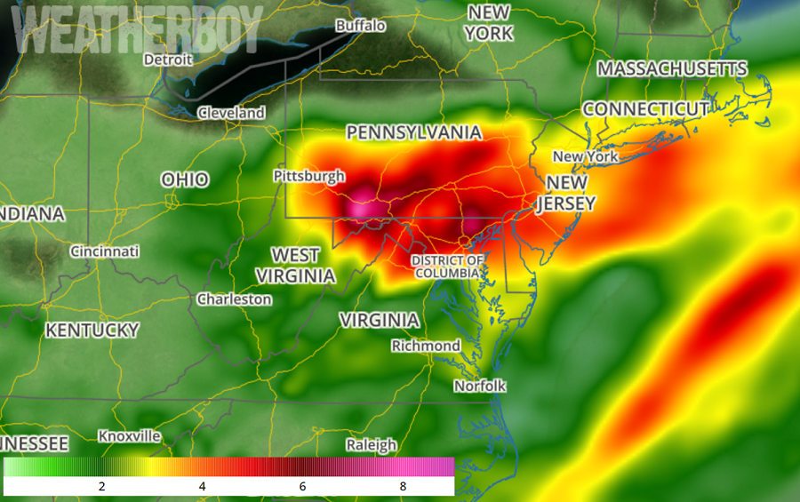
Overall, total rainfall when all is done will be around 1-2″ over northern New Jersey and the Lehigh Valley of Pennsylvania, 2-3″ inches over the Delaware Valley and southern New Jersey, and 3-3.5″  inches over the DelMarVa region. Beyond these healthy amounts, thunderstorms may bring locally higher totals to some areas; amounts over 4″ are possible in this region. Because of this heavy rain threat, the National Weather Service  office responsible for the Philadelphia metro area says, “eventually, flood watches may be issued for parts of the region, so pay attention to future forecasts.”

With abundant clouds and heavy precipitation, temperatures will be mostly below normal Friday and into the weekend.

Primary Sidebar

Sponsored Ad

Search

Latest News

  • USGS Scientists Monitoring Volcano for Signs of Eruption
  • Swirl of Clouds Causes Concern Near Florida Day Before Hurricane Season Starts
  • People Report Shaking as Earthquake Strikes New Hampshire
  • Smoke from Nova Scotia Fires Invade New Jersey; Prompts Air Quality Alert
  • Multiple Earthquakes Shake Kentucky & Tennessee, Not Far from New Madrid Seismic Zone
  • May Ends on a Very Dry Note in the Northeast; Philadelphia About to Break Record
  • Carnival Sunshine Cruise Ship Sails into East Coast Storm, Creating Injuries & Damage On-Board
  • Space Weather Forecaster Sought; Pay Up to $183,500/year Offered
About | Careers | Contact | Contests
Terms | Privacy | Ad Choices
Weatherboy is a (R) Registered Trademark of isarithm LLC, All Rights Reserved.
All content herein is Copyright by Isarithm LLC 1997-2022