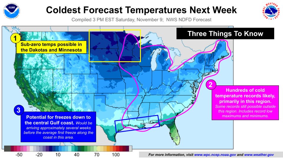
A very cold winter-like outbreak will occur over a large part of the United States in the coming days, setting the stage for hundreds of cold temperature records to be shattered. The National Weather Service is tracking three concern areas: first, the first is an area of dangerously cold temperatures below zero degrees F in portions of the Dakotas and Minnesota; second, over all of the eastern United States, central and southern Florida excluded, where records are likely to fall; third, along the central Gulf Coast, where freeze conditions could occur weeks earlier than usual.
Arctic air pushing into the U.S. early next week from Canada is responsible for wintry blast. For some, the cold air will also be joined by early season snowfall, especially over portions of the Rockies, the central plains, and northern New England.
Cold weather has already lead to records being broken in the eastern U.S. today. Baltimore, Maryland broke its daily low temperature record this morning; the 24 broke the 25 record that was previously set in 2003, 1976, and 1967. Islip, New York tied the 1992 record low of 23; JFK Airport in New York tied the 1976 record low of 25, and Bridgeport, Connecticut tied their record low of 22 which was set in 1971. Trenton, NJ’s low this morning of 19 shattered the previous record of 24 set in 2003; Wilmington, Delaware tied their 24 degree record low with the 1976 and 1971 reading. And on Mount Pocono, which saw snow yesterday, had a new record low of 11, breaking the old record of 13 set in 1976 and 1971.
As part of this upcoming record cold blast, the National Weather Service believes it’s possible record lows will be broken on November 13 or 14 for Allentown, Mount Pocono, Philadelphia, and Reading in Pennsylvania, Atlantic City and Trenton in New Jersey, and Georgetown and Wilmington in Delaware. Hundreds of other cities from New England to the Gulf Coast may join them with new record cold temperatures in the coming days.