
The National Hurricane Center has Storm Surge Warnings and Hurricane Warnings up for portions of the Texas coast, where Beryl is expected to make landfall as a hurricane Monday morning.
Right now, the National Hurricane Center has issued a Hurricane Warning for the Texas coast from Baffin Bay northward to Sargent. A Hurricane Watch is in effect for the Texas coast south of Baffin Bay to the mouth of the Rio Grande River and the Texas coast north of Sargent to San Luis Pass. A Hurricane Warning means that hurricane conditions are expected somewhere within the warning area. A warning is typically issued 36 hours before the anticipated first occurrence of tropical-storm-force winds, conditions that make outside preparations difficult or dangerous. Preparations to protect life and property should be rushed to completion.
A Tropical Storm Warning is also in effect for the Texas coast south of Baffin Bay to the mouth of the Rio Grande River, the Texas coast north of Sargent to High Island, and the northeastern coast of mainland Mexico from Barra el Mezquital to the mouth of the Rio Grande River. A Tropical Storm Warning means that tropical storm conditions are expected somewhere within the warning area within 36 hours.
A Storm Surge Warning is in effect for the North Entrance of the Padre Island National Seashore to High Island, including Corpus Christi Bay, Matagorda Bay, and Galveston Bay. A Storm Surge Watch is also in effect for the Texas coast from the mouth of the Rio Grande River northward to North Entrance of the Padre Island National Seashore and from San Luis Pass to Sabine Pass, including Galveston Bay. A Storm Surge Warning means there is a danger of life-threatening inundation, from rising water moving inland from the coastline, during the next 36 hours in the indicated locations. A Storm Surge Watch means there is a possibility of life-threatening inundation, from rising water moving inland from the coastline, in the indicated locations during the next 48 hours.
According to the National Hurricane Center, strengthening of the storm is expected, and Beryl is forecast to become a hurricane again later today or tonight before it reaches the Texas coast Monday morning.
Hurricane conditions are expected in the hurricane warning area by early Monday. Winds are first expected to reach tropical storm strength by late today, making outdoor preparations difficult or dangerous. Hurricane conditions are possible in the hurricane watch areas by early Monday, with tropical storm conditions beginning by tonight. Tropical storm conditions are expected in the tropical storm warning areas in Texas and northeastern Mexico by tonight.
The combination of storm surge and tide will cause normally dry areas near the coast to be flooded by rising waters moving inland from the shoreline. The water could reach the following heights above ground somewhere in the indicated areas if the peak surge occurs at the time of high tide:
- Mesquite Bay, TX to Freeport, TX…4-6 feet
- Matagorda Bay…4-6 feet
- Freeport, TX to High Island, TX…3-5 feet
- N Entrance Padre Island NS, TX to Mesquite Bay, TX…3-5 feet
- Corpus Christi Bay…3-5 feet
- Galveston Bay…3-5 feet
- Mouth of the Rio Grande, TX to N Entrance Padre Island NS, TX…2-4 feet
- High Island, TX to Sabine Pass, TX…2-4 feet
- Sabine Pass, TX to Cameron, LA…1-3 feet
The deepest water will occur along the immediate coast near and to the right of the center, where the surge will be accompanied by large and destructive waves. Surge-related flooding depends on the relative timing of the surge and the tidal cycle, and can vary greatly over short distances.
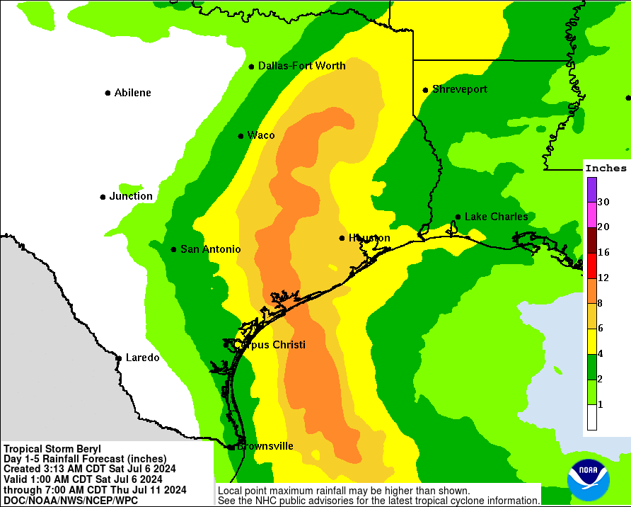
Heavy rainfall of 5-10″ with localized amounts of 15″ is expected across portions of the Texas Gulf Coast and eastern Texas beginning late today through midweek. This rainfall will produce areas of flash and urban flooding, some of which may be locally considerable. Minor to isolated moderate river flooding is also expected.
A few tornadoes could occur along the Texas Coast this afternoon and tonight.
Swells generated by Beryl are expected to affect eastern Mexico and much of the Gulf Coast of the U.S. during the next few days. These swells are expected to cause life-threatening surf and rip current conditions.
The National Hurricane Center wants to convey these four important, key messages:
- There is a danger of life-threatening storm surge inundation late Sunday night and Monday along the coast of Texas from the north entrance to the Padre Island National Seashore to High Island, including Corpus Christi Bay, Matagorda Bay, and Galveston Bay. Residents in those areas should follow any advice given by local officials and follow evacuation orders.
- Beryl is forecast to bring damaging hurricane-force winds to portions of the lower and middle Texas coast late Sunday night and Monday. A Hurricane Warning is in effect from Baffin Bay to Sargent. Preparations should be rushed to completion before tropical storm conditions begin late Sunday.
- Flash and urban flooding, some of which may be locally considerable, is likely across portions of the Texas Gulf Coast and eastern Texas beginning late Sunday through the middle of next week. River flooding is also possible.
- Rip currents will cause life-threatening beach conditions through Monday across much of the Gulf Coast. Beachgoers should heed warning flags and the advice of lifeguards and local officials before venturing into the water.
