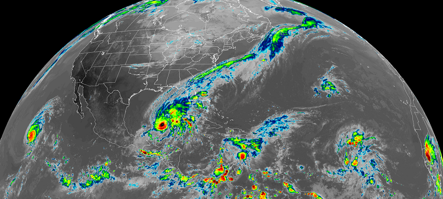
The National Hurricane Center is busy tracking multiple tropical cyclone threats on this 50th birthday of its parent agency, NOAA. While Hurricane Marie is spinning about in the open waters of the eastern Pacific, there are threats closer to land in the Atlantic Hurricane Basin, including Gamma which is traveling across the Yucatan Peninsula right now.
In the latest advisory update from the National Hurricane Center, Tropical Storm Gamma was located about 35 miles north-northwest of Tulum, Mexico. With maximum sustained winds of 65 mph, Gamma is moving to the northwest at 8 mph with a minimum central pressure of 985 mb or 29.09 inches.
Gamma is expected to produce heavy rainfall for several days over portions of southeastern Mexico, the Yucatan Peninsula, Central America, and far western Cuba. This rainfall could result in life-threatening flash flooding and mudslides, particularly in the mountainous regions of southeastern Mexico and Central America. Even though Gamma has moved inland, tropical storm conditions will continue along the east coast of the Yucatan Peninsula through this evening and are expected to spread along the north coast within the Tropical Storm Warning area tonight and on Sunday.
Gamma is forecast to make a sharp left turn over the open Gulf of Mexico and stall there for a few days. By Tuesday, the storm should still be over the Bay of Campeche over the southern Gulf of Mexico.
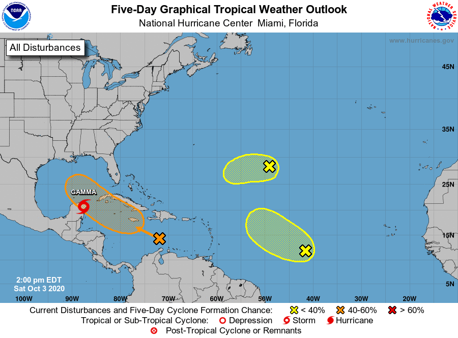
While Gamma is spinning about there, a new system could be more of a threat to the United States. According to the National Hurricane Center, shower and thunderstorm activity has become more consolidated since yesterday near a tropical wave located over the central Caribbean Sea. Environmental conditions are expected to become more conducive for development, and a tropical depression could form next week while the system moves westward or west-northwestward at about 15 mph across the central and western Caribbean Sea and then into the southern Gulf of Mexico. If this system develops further into a tropical storm, it would be named Delta.
Locally heavy rainfall and gusty winds will be possible across portions of Hispaniola, Jamaica, Cuba, and the Cayman Islands during the next few days, The National Hurricane Center says interests on those islands should monitor the progress of this disturbance. Right now, they say there’s a 60% chance that this system will become a tropical cyclone within the next 5 days.
Another area of concern is a tropical wave located over the central tropical Atlantic. Today, it is producing disorganized showers and thunderstorms. This system is expected to move toward the west-northwest or northwest at 10 to 15 mph, and some development is possible during the next couple of days before it encounters strong upper-level winds. Because it doesn’t have much time to form into a tropical cyclone, the National Hurricane Center says there’s only a 20% chance of cyclone formation over the next 48 hours or 5 days.
The fourth area of concern being tracked by the National Hurricane Center is an area of disorganized showers and thunderstorms over the central Atlantic more than 1000 miles east-southeast of Bermuda. This area is associated with a surface trough of low pressure. This system is expected to move toward the west-southwest at around 10 mph, and some slow development is possible during the next couple of days before it too encounters strong upper-level winds. There’s even a smaller chance of this system developing into a tropical cyclone, with the National Hurricane Center putting a 10% chance of formation over the next 48 hours or 5 days.
Because the list of typical storm names has been exhausted this year, the National Hurricane Center will use letters from the Greek alphabet moving forward. Beyond Gamma and Delta would be Epsilon and Zeta. There has never been a storm beyond Zeta on record in the Atlantic basin. It is too soon to tell whether that’ll happen this year: the hurricane season continues to run through to the end of November.
