Hurricane Elsa is the first hurricane of the 2021 Atlantic Hurricane Season and it’s already breaking records; unfortunately, it is becoming increasingly likely that the system will impact the U.S. next week.
Elsa became a tropical storm yesterday and a hurricane this morning. The earliest fifth named storm in the Atlantic basin was Edouard, which formed on July 6. In addition to beating that date for a record, Elsa reached hurricane strength at 59.8°W, making it the farthest east that a hurricane has formed this early in the calendar year since 1933. Elsa also arrives on the scene extra early; the average first Atlantic hurricane formation date is August 14 when examining records from 1991-2020.
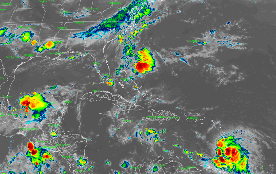
With winds of 75 mph and minimum central pressure of 995 or 29.39″, Hurricane Elsa is a Category 1 hurricane on the Saffir-Simpson hurricane wind scale. Elsa is located roughly 40 miles west of Barbados and 75 miles east of St. Vincent. It is moving to the west north west at a brisk 28 mph.
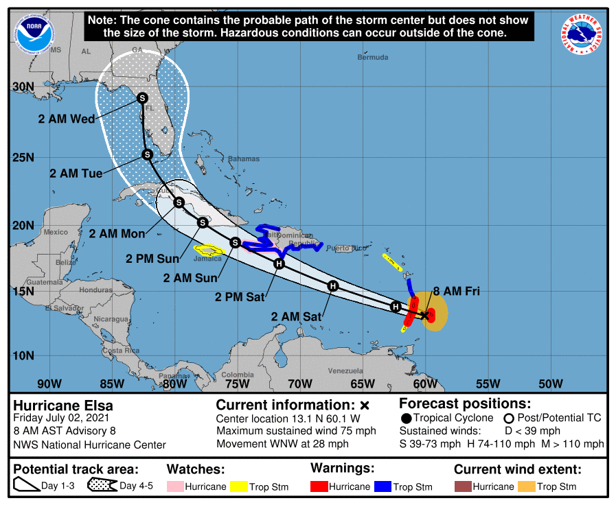
With the storm rapidly arriving, the Meteorological Service of Barbados has issued a Hurricane Warning for Barbados, St. Vincent, and the Grenadines while the Meteorological Service of St. Lucia has issued a Hurricane Warning for St. Lucia. A Tropical Storm Warning is also in effect for Martinique, the southern coast of Dominican Republic from Cabo Engano to the border with Haiti, and the entire coast of Haiti. A Hurricane Watch is in effect for the southern portion of Haiti from Port Au Prince to the southern border with the Dominican Republic. Tropical Storm Watches are up for Grenada and its dependencies, Saba and Sint Eustatius, all of Jamaica, and Dominica. A Hurricane Warning means that hurricane conditions are expected somewhere within the warning area, in this case in the next few hours. Preparations to protect life and property should be rushed
to completion there. A Tropical Storm Warning means that tropical storm conditions are expected somewhere within the warning area. A Hurricane Watch means that hurricane conditions are possible within the watch area. A watch is typically issued 48 hours before the anticipated first occurrence of tropical-storm-force winds, conditions that make outside preparations difficult or dangerous. A Tropical Storm Watch means that tropical storm conditions are possible within the watch area.
The National Hurricane Center (NHC) in Miami, Florida says that additional warnings will likely be required later today, including Hurricane Warnings for portions of Haiti and the Dominican Republic.

Elsa is expected to continue its west-northwest march through the Caribbean over the next few days. On the forecast track provided by the NHC, Elsa will pass near or over portions of the Windward Islands or the southern Leeward Islands this morning, move across the eastern Caribbean Sea late today and tonight, and move near the southern coast of Hispaniola on Saturday. By Sunday, Elsa is forecast to move near Jamaica and portions of eastern Cuba.
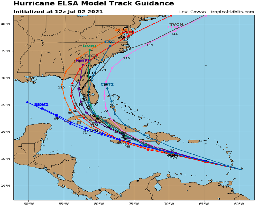
Many questions remain unanswered about Elsa’s future beyond its rendezvous with Cuba. Depending how close Elsa gets to Haiti and Cuba and it’s mountainous terrain, the storm could significantly weaken. The European ECMWF global forecast model suggests such a weakening will occur while the American GFS global forecast model suggests limited disruptive interaction with the mountainous terrain there, leading to a more impressive system heading to the United States. Most model solutions do bring Elsa in some form to the United States, increasing odds for tropical trouble in the Eastern U.S. during the middle of next week.
The latest NHC forecast brings Elsa into the Florida after the Fourth of July holiday weekend. By Tuesday early morning, the NHC brings the center of Elsa near or over Key West, Florida and eventually inland into Florida along its Gulf Coast somewhere between Cape Coral and Tampa Bay. Even if the center were to follow such a path, most of Florida would see significant rain and wind from the storm.

As Hurricane Elsa impacts land, a variety of hazards will be present: damaging winds, storm surge, flooding rains, and isolated tornadoes.
Hurricane wind conditions are occurring on Barbados, and are expected in the hurricane warning area in the Windward Islands in the next few hours, according to the NHC. Tropical storm force wind conditions are expected in portions of the Windward and southern Leeward Islands within the tropical storm warning areas and are possible in the tropical storm watch areas later today. Tropical storm conditions are expected in the warning areas in the Dominican Republic and Haiti on Saturday, with hurricane conditions possible in southern Haiti. Tropical storm conditions are possible in Jamaica Saturday night or early Sunday.
A storm surge will raise water levels by as much as 1-3′ above normal tide levels in areas of onshore winds in the hurricane warning area in the Windward Islands and along the southern coast of Hispaniola.
Elsa is expected to produce rainfall totals of 3-6″ with maximum amounts of 10″ today across the Windward and southern Leeward Islands, including Barbados. This rain may lead to isolated flash flooding and mudslides. Over Puerto Rico, rainfall of 1-3″ with localized amounts of 5″ is expected late today into Saturday. Across portions of southern Hispaniola and Jamaica, rainfall of 4-8″ with isolated maximum amounts of 12″ is possible Saturday into Sunday. All of this heavy rain may lead to scattered flash flooding and mud and rock slides along hillsides too.
Isolated tornadoes may spin up within the hurricane’s bands as it interacts with land. Such tornadoes may pop-up with little to no advance notice.