
The National Hurricane Center (NHC) in Miami, Florida is forecasting that Hurricane Erin will undergo a period of rapid intensification on its way to Major Hurricane status, with maximum sustained winds greater than 115 mph.
“Erin will become a powerful and increasingly large hurricane over the southwestern Atlantic over the weekend and into next week,” warns the National Hurricane Center, adding that, “It should be noted that the the Florida State Super Ensemble and the US Navy COAMPS-TC models forecast higher peak intensities than the official forecast, so it would not be too surprising if Erin became stronger than currently forecast.” The official forecast brings Erin’s top winds to 140 mph 72 hours, so it wouldn’t take much beyond that to get to Category 5 status on the Saffir-Simpson Wind Scale where 155 mph or greater winds top out the chart.
Hurricane Erin will bring many hazards with it. Heavy rainfall tonight through Sunday across the northern Leeward Islands, the Virgin Islands, and Puerto Rico may lead to isolated and locally considerable flash and urban flooding, along with landslides or mudslides. Tropical storm wind conditions are possible for portions of the northern Leeward Islands, where Tropical Storm Watches are in effect, beginning on Saturday as the core of Erin passes north of those islands. Gusts to tropical storm force are possible in rainbands over portions of the Virgin Islands and Puerto Rico later in the weekend.
While the threat of direct impacts in the Bahamas and along the east coast of the United States appears to be gradually decreasing, there will still be a significant risk of dangerous surf and rip currents along western Atlantic beaches next week.
The NHC also urges caution for those in Bermuda, saying that people there should continue to monitor the progress of Erin since there is still a risk of strong winds, heavy rainfall, and high surf by the middle part of next week.
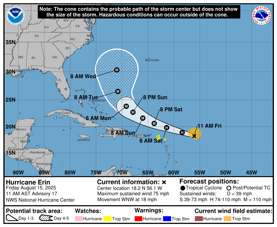
Hurricane Erin became the first hurricane of the 2025 Atlantic Hurricane Season this morning. With winds of 75 mph, it is currently located about 460 miles east of the Northern Leeward Islands with a minimum central pressure of 996 mb or 29.42″.
Erin is moving toward the west-northwest near 18 mph. This motion is expected to continue by the NHC into the weekend. On the forecast track, the center of Erin is likely to move near or just north of the northern Leeward Islands over the weekend.
Reports from NOAA and Air Force Reserve Hurricane Hunter aircraft indicate that maximum sustained winds have increased to near 75 mph with higher gusts. Steady to rapid strengthening is expected during the next two to three days, and Erin is forecast to become a major hurricane during the weekend. Major hurricanes have winds of at least 115 mph sustained.
For now, a Tropical Storm Watch is in effect for Anguilla and Barbuda, St. Martin and St. Barthelemy, Saba and St. Eustatius, and Sint Maarten. A Tropical Storm Watch means that tropical storm conditions are possible within the watch area, generally within 48 hours.
“Interests elsewhere in the northern Leeward Islands, Virgin Islands, and Puerto Rico should monitor the progress of Erin,” says the National Hurricane Center.
The outer bands of Erin are expected to produce areas of heavy rainfall tonight into Sunday across the northern Leeward Islands, the Virgin Islands, and Puerto Rico. Rainfall totals of 2-4″, with isolated totals of 6″, are expected. This rainfall may lead to isolated and locally considerable flash and urban flooding, along with landslides or mudslides.
Tropical storm wind conditions are possible within the watch area by early Saturday.
Swells generated by Erin will begin affecting portions of the northern Leeward Islands, the Virgin Islands and Puerto Rico by this weekend, and will likely spread to the western Atlantic next week. These swells are likely to cause life-threatening surf and rip current conditions.
The 2025 Atlantic Hurricane Season continues through to the end of November and is expected to peak over the next 4 weeks. The average first date of hurricane formation in the Atlantic Basin is August 11; as a result, Erin is almost on-target for a typical year. Since 2010, four seasons have had their first hurricane after August 15: 2011, 2013, 2015, and 2022.
