Hurricane Eta is in the midst of a rapid intensification cycle; it is forecast to bring catastrophic impacts to portions of Central America where its initial landfall is expected first. Beyond there, the storm could curve to the north and eventually impact the United States over time. With hurricane season running through to the end of the month, people in the USA should not let their guard down to tropical cyclone threats anytime soon.
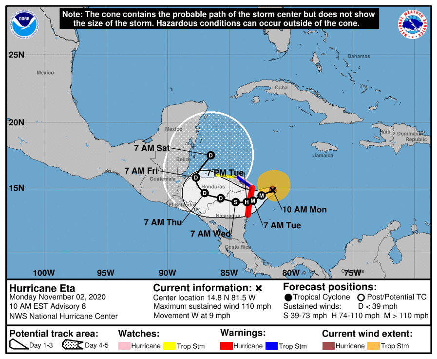
As of the latest advisory from the National Hurricane Center, Hurricane Eta is roughly 115 miles east of Cabo Gracias a Dios on the Nicaragua/Honduras border. With maximum sustained winds of 110 mph, the storm is moving due west at 9 mph with a minimum central pressure of 962 mb or 28.41″.
The National Hurricane Center says a “life-threatening storm surge, catastrophic winds, flash flooding, and landslides are expected across portions of Central America” with Eta’s arrival. Because of that, a Hurricane Warning is in effect for the coast of Nicaragua from the Honduras/Nicaragua border to Sandy Bay Sirpi. A Tropical Storm Warning is also in effect for the northeastern coast of Honduras from Punta Patuca to the Honduras/Nicaragua border. A Hurricane Watch is in effect for the northeastern coast of Honduras from Punta Patuca to the Honduras/Nicaragua border while a Tropical Storm Watch is in effect for the northern coast of Honduras from west of Punta Patuca westward to Punta Castilla.
Eta is slowing down while gaining strength, a lethal combination for a tropical cyclone. While Eta is moving toward the west near 9 mph for now, the National Hurricane Center says a slower motion toward the west-southwest is forecast by this afternoon and will continue into Tuesday. On the forecast track, the center of Eta is expected to approach the northeastern coast of Nicaragua later today, and make landfall within the Hurricane Warning area in Nicaragua on Tuesday. The center of Eta is forecast to move farther inland over northern Nicaragua through Wednesday night.
As Eta moves into Central America, it is getting stronger. Reconnaissance aircraft and satellite data indicate that Eta is rapidly strengthening. Maximum sustained winds have increased to near 110 mph with higher gusts. Continued rapid strengthening is expected through early Tuesday, and Eta is expected to become a major hurricane very soon. However, once Eta strikes the coast and moves inland, weakening will begin.
Computer model forecast guidance has been suggesting that Eta would curve back towards the Caribbean after impacting Central America rather than simply crossing Central America completely. The National Hurricane Center now favors such a path, bringing Eta back over open waters of the Caribbean east of Central America by Saturday.
The latest American GFS model forecast shows the storm wandering near Cuba for several days before moving towards Florida, the Gulf of Mexico, and/or the U.S. Gulf Coast. It suggests Eta would strike the United States as a hurricane. Long range guidance from the GFS model also suggests significant impacts over time to the eastern United States from this storm and/or its remnants.
The overnight European ECMWF model shows a path similar to the American GFS over the next 10 days, showing Eta even stronger than what the GFS suggests. By the later part of next week, it has the hurricane ready to enter the Gulf of Mexico near western Cuba.
It is too soon to say with certainty whether these model projects are accurate. Forecast accuracy for models decays after five days; projections dealing with tropical cyclones are even worse than that. It is just too soon for meteorologists to commit to a U.S. landfall for Eta at this point.
Unfortunately, it isn’t too soon to point out just how bad Eta will be for Central America.
Incredible amounts of forecast rain are expected to would lead to catastrophic, life-threatening flash flooding and river flooding, along with landslides in areas of higher terrain of Central America. Flash flooding and river flooding would be possible across Jamaica, southeast Mexico, El Salvador, southern Haiti, and the Cayman Islands.
A dangerous storm surge will raise water levels by as much as 12 to 18 feet above normal tide levels in areas of onshore winds along the coast of Nicaragua within the hurricane warning area, and 3 to 5 feet above normal tide levels along the coast of Honduras within the tropical storm warning area. Near the coast, the surge will be accompanied by large and destructive waves.
Swells generated by Eta are expected to affect portions of the coast of Central America and the Yucatan Peninsula of Mexico during the next few days. These swells are likely to cause life-threatening surf and rip current conditions.
While Eta is more than a week away from potentially impacting the USA, residents in the U.S. should closely monitor its future progress. With Hurricane Season still not over, people should still have a Hurricane Action Plan in place and be prepared to act on it should a tropical cyclone threaten their area.
