Portions of the Louisiana coastline may be uninhabitable for weeks or months after the wrath of Major Hurricane Ida is complete: an epic storm surge, massive flooding rains, and powerful, destructive winds are forecast to smash into the state tomorrow. Tomorrow also happens to be the 16th anniversary of New Orleans’ destructive impacts with Hurricane Katrina.
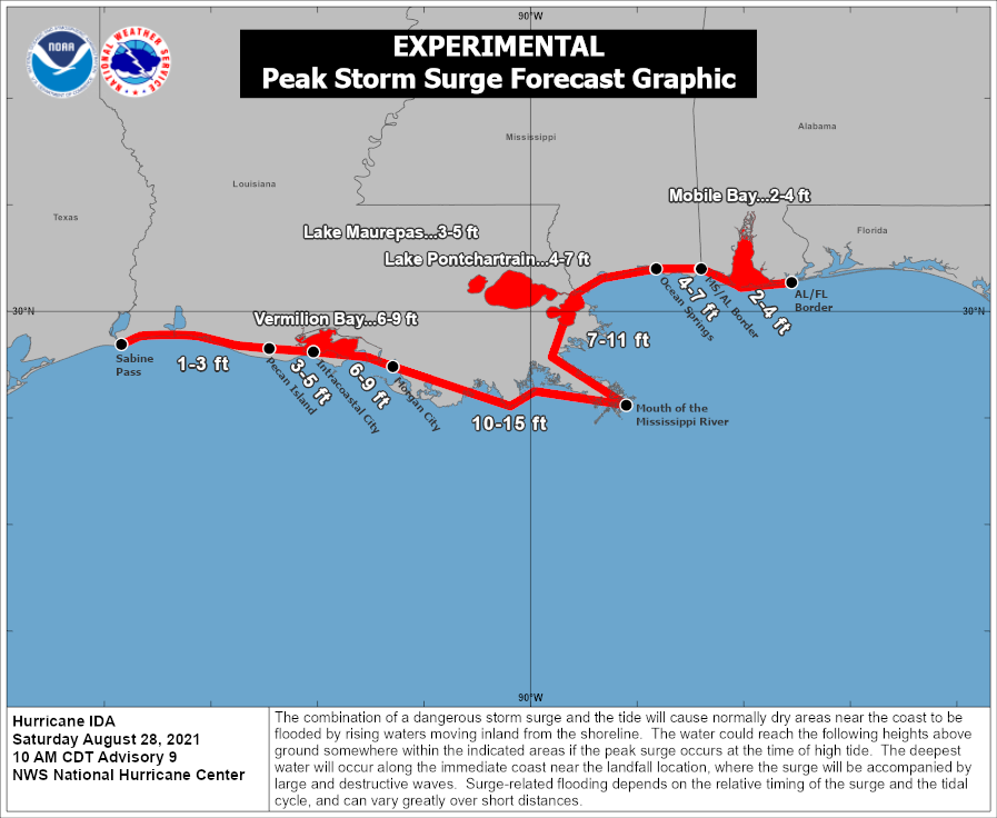
The National Weather Service wants people today to protect against life-threatening surge having possible catastrophic impacts across all of coastal southeast Louisiana and portions of coastal Mississippi west of Biloxi. Potential impacts in this area include widespread deep inundation, with storm surge flooding greatly accentuated by powerful battering waves. Here, structural damage to buildings, with many washing away, is likely. To make matters worse, damage will be greatly compounded from considerable floating debris. The storm surge will also wash-out or severely flood near-shore escape routes and secondary roads. Even flood control systems and barriers may become stressed. At the coast, there will be extreme beach erosion with new shoreline cuts possible; there will also be massive damage to marinas, docks, boardwalks, and piers. Numerous small craft will break away from moorings with many lifted onshore and stranded far from the coast.
Destructive category 4 or greater strength winds are likely, bringing about devastating impacts across portions of Southeast Louisiana mainly along and to the west of the I-55 corridor including metro Baton Rouge, western portions of metro New Orleans, and the Houma metropolitan area. In this area, the National Weather Service warns of structural damage to sturdy buildings, some with complete roof
and wall failures. The National Weather Service says there will be complete destruction of mobile homes. Damage to all structures will be greatly accentuated by large airborne projectiles. There will be thousands of large trees snapped or uprooted along with fences and
roadway signs blown over; many roads will be impassable from large debris, and more within urban or heavily wooded places. Many bridges, causeways, and access routes could be impassable for an extended period of time. The wind will also knock-out power and communication for weeks, months, or longer for some.
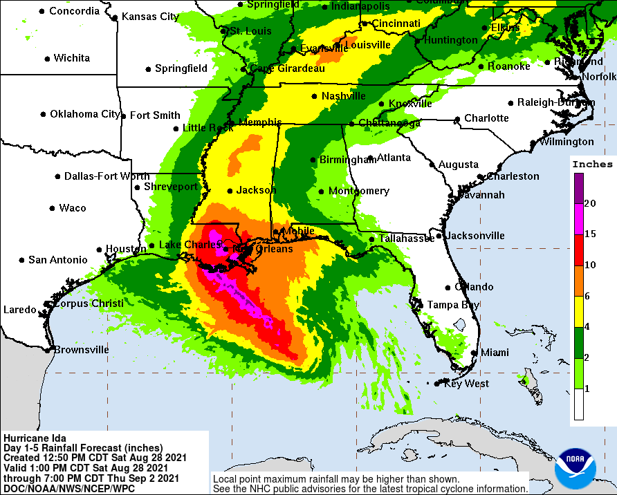
Heavy rains associated with the major hurricane will produce devastating impacts across portions of Southeast Louisiana including
metro New Orleans, metro Baton Rouge, the River Parishes, and the Houma metropolitan area. Extreme rainfall flooding may prompt numerous evacuations and rescues. Rivers and tributaries may overwhelmingly overflow their banks in many places with deep moving water. Small streams, creeks, canals, and ditches may become raging rivers. Flood control systems and barriers may become stressed. Expected flood waters will enter numerous structures within multiple communities, with some structures becoming uninhabitable or washed
away. Streets and parking lots will become rivers of raging water with underpasses submerged, with driving conditions become very
dangerous if not impossible. Numerous road and bridge closures are likely with some weakened or washed out.
The landfalling system will also produce numerous tornadoes. With destructive winds compromising radio and RADAR towers, in additional to all other communication channels, tornadoes could strike with no advance notice.
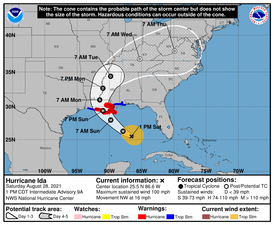
As of the latest update from the National Hurricane Center, Ida was located about 290 miles east-southeast of the mouth of the Mississippi River and about 380 miles southeast of Houma, Louisiana. Maximum sustained winds are at 100 mph while the minimum central pressure is 976 mb or 28.82″. The storm is moving to the northwest at 16 mph.
Ida’s northwest movement is forecast to continue through late Sunday or early Monday, followed by a slower northward motion after landfall. On the forecast track, the center of Ida will move over the southeastern and central Gulf of Mexico through tonight. Ida is then expected to make landfall along the coast of Louisiana within the hurricane warning area on Sunday, and then move inland over portions of Louisiana and western Mississippi later on Monday.
Additional rapid strengthening is forecast during the next 24 hours and Ida is expected to be an extremely dangerous major hurricane when it approaches the northern Gulf coast on Sunday. Weakening is expected after Ida makes landfall. Hurricane-force winds extend outward up to 30 miles from the center and tropical-storm-force winds extend outward up to 125 miles.
