• Skip to primary navigation
  • Skip to main content
  • Skip to primary sidebar

Weatherboy

Weatherboy Weather News, Maps, RADAR, Satellite, and Forecasts.

  • Local
  • Earth Science News
  • RADAR
  • Current Warnings
  • Satellite
  • Current Maps
  • Forecast Maps
  • Video

HURRICANE IRMA LANDFALL

by Weatherboy Team Meteorologist - September 10, 2017

Satellite view of Hurricane Irma after landfall through the Florida Keys. Image: NOAA

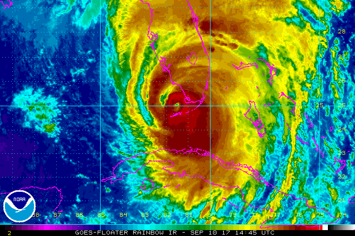
After a long and catastrophic path through the Caribbean that shattered numerous weather records, Major Hurricane Irma finally made landfall on the United States at 9:10am on September 10, 2017. With maximum sustained winds of 130mph with higher gusts, Irma crossed Cudjoe Key at 24.7N 81.5W as a Category 4 hurricane. Minimum pressure at landfall was at 929mb. This is the first time in recorded history that two category four hurricanes made landfall on the US in the same season. Today also marks the traditional peak of the Atlantic Hurricane Season. 


Last surge forecast from the National Hurricane Center shows a catastrophic surge in red covering Sanibel Island, Fort Meyers Beach, and large parts of Cape Coral. Here, the water could be deeper than 10' on land. Image: NHC
Last surge forecast from the National Hurricane Center shows a catastrophic surge in red covering Sanibel Island, Fort Meyers Beach, and large parts of Cape Coral. Here, the water could be deeper than 10′ on land. Image: NHC

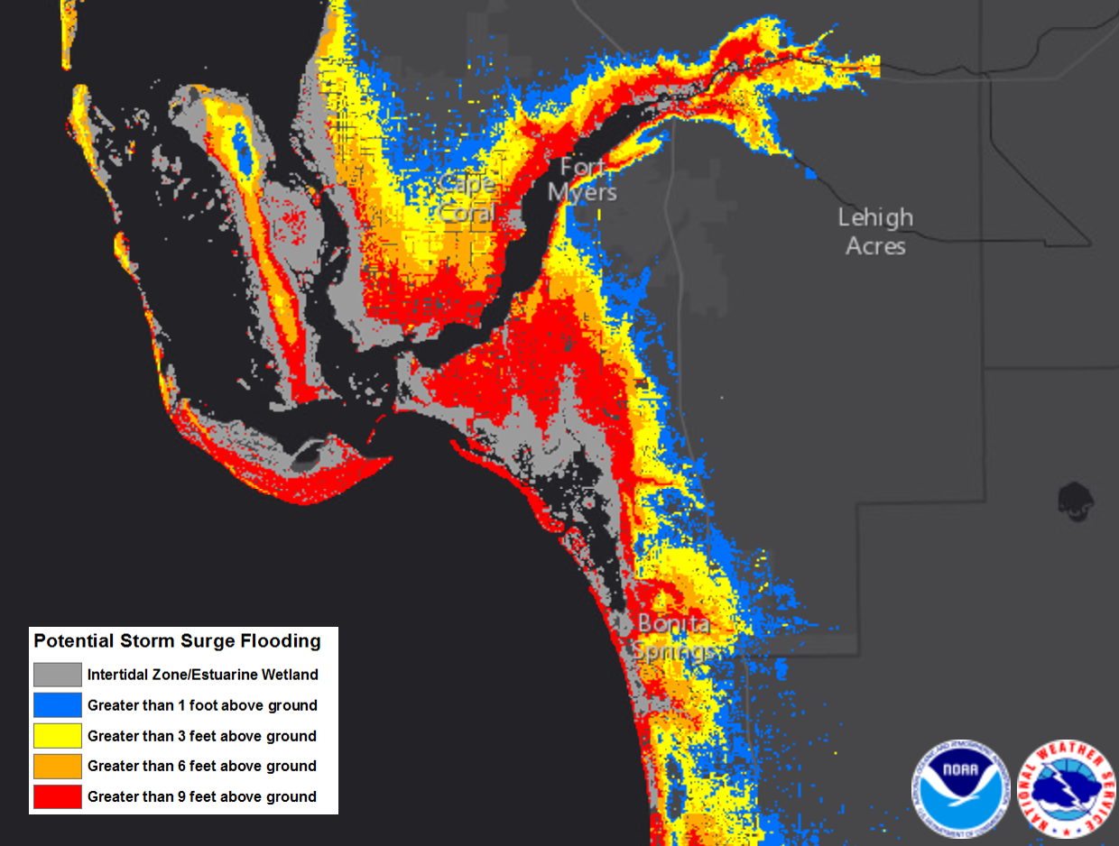
The storm is forecast to continue to move north into the Florida Peninsula. Based on its approach, Fort Meyers, Sanibel Island, and Cape Coral appear to be at ground zero where the worst storm surge will hit. Here, the Gulf of Mexico will surge well inland, sending in 10-15 feet of water through populated areas there.

Powerful winds will continue to plow up the west coast of Florida, with gusts over 140mph possible from Marco Island to Sarasota. Hurricane force winds of 75mph or more are expected over southern and central Florida along and sound of I-4 today. Tropical Storm Force winds will spread over all of Florida and into Georgia and South Carolina later tonight into tomorrow.


Frequent tornadoes are being spawned by the bands of convection that surround Hurricane Irma’s eye. Numerous tornado warnings are being issued throughout the Florida Peninsula and this tornado risk will continue all day and night.


Primary Sidebar

Sponsored Ad

Search

Latest News

  • Severe Storm and Flash Flood Threats Persist in Mid Atlantic
  • Chantal’s Remnants Push Flood Threat to New Jersey and Pennsylvania
  • Death Toll Rises as Major Federal Disaster Declaration Signed
  • Tropical Chantal Moves Inland, Soaking Mid Atlantic
  • Tropical Storm Warnings Issued as Chantal Approaches East Coast
  • Tropical Storm Watches Issued for East Coast as Tropical Depression Forms
  • System to Impact Southeast U.S. This Weekend Says National Hurricane Center
  • Hurricane Center Says East Coast System Likely to Develop
About | Careers | Contact | Contests
Terms | Privacy | Ad Choices
Weatherboy is a (R) Registered Trademark of isarithm LLC, All Rights Reserved.
All content herein is Copyright by Isarithm LLC 1997-2022