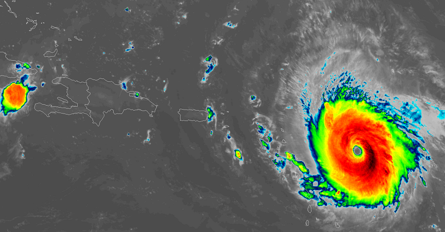
Hurricane Irma has gone through a period of explosive growth and now sits at the top of the Saffir-Simpson wind scale as a Category 5 hurricane. Major Hurricane Irma now has maximum sustained winds of 175mph with wind gusts to 213mph. As of 8am, it was located at 16.7N 57.7W, which is about 270 miles east of Antigua and 280 miles east of Barbuda. The storm is moving west at 14mph. Minimum central pressure is at 929mb / 27.44″ and falling.
A slew of warnings and watches are in effect. The government of the Dominican Republic has just issued a Hurricane Watch from Cabo Engano to the northern border with Haiti and a Tropical Storm Watch from south of Cabo Engao to Isla Saona.
Hurricane Warnings are now up for:
- Antigua, Barbuda, Anguilla, Montserrat, St. Kitts, and Nevis
- Saba, St. Eustatius, and Sint Maarten
- Saint Martin and Saint Barthelemy
- British Virgin Islands
- U.S. Virgin Islands
- Puerto Rico, Vieques, and Culebra
Hurricane Watch is now up for:
- Guadeloupe
- Dominican Republic from Cabo Engano to the northern border with Haiti
A Tropical Storm Warning is in effect for:
- Guadeloupe
- Dominica
A Tropical Storm Watch is in effect for:
- Dominican Republic from south of Cabo Engao to Isla Saona
A Hurricane Warning means that hurricane conditions are expected somewhere within the warning area. A warning is typically issued 36 hours before the anticipated first occurrence of tropical-storm-force winds, conditions that make outside preparations difficult or dangerous. In this case, for some of easternmost islands, the hurricane conditions are expected within the next 24 hours. Preparations to protect life and property should be rushed to completion.
A Tropical Storm Warning means that tropical storm conditions are expected somewhere within the warning area in this case within 36 hours.
A Tropical Storm Watch means that tropical storm conditions are possible within the watch area, generally within 48 hours.