All eyes are back on the tropics today now that the National Hurricane Center initiated advisories on Tropical Storm Matthew, a storm system expected to grow into a hurricane later this week. More concerning is that major computer model forecasts are calling for the possibility of a significant US landfall in early October. It is likely that Matthew will become the strongest storm of the 2016 Atlantic Hurricane Season and it is also quite possible that Matthew may be the strongest storm to strike the United States in many years.
Have questions about Matthew? Ask them in our Disqus comment section below.
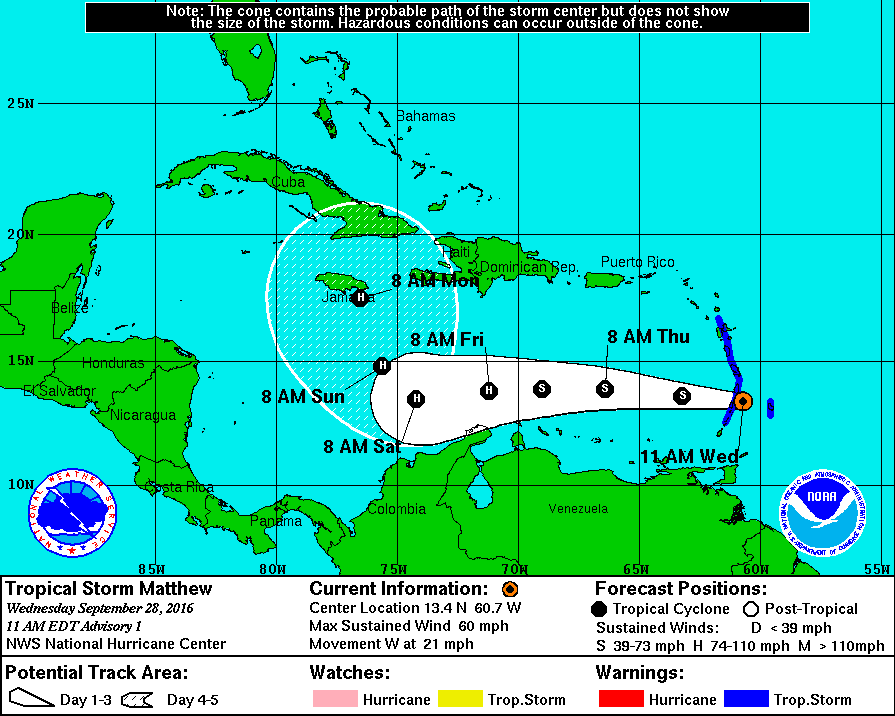
In the initial advisory issued at 11am ET today, surface observations and data from an Air Force Reserve reconnaissance aircraft indicate that the tropical wave we’ve been tracking for the last week finally aquired a closed circulation. The
reconnaissance aircraft found peak flight-level winds of 64 kt which is roughly 73mph and surface winds of around 50 kt (58 mph) over the northern portion of the circulation. Because of the strong winds and the closed circulation, the National Hurricane Center decided to upgrade the tropical wave all the way up to Tropical Storm status. The current lack of inner core structure suggests that further strengthening should be limited today, but environmental
conditions consisting of warm water and low shear ahead of Matthew favor intensification throughout the remainder of the forecast period. While statistical guidance brings Matthew to Category 3 hurricane in 72 hours, the National Hurricane Center intensity forecast is more conservative but follows the trends of the global models in deepening the system.
Since the center has very recently formed, the initial motion estimate is a highly uncertain west at 20mph. A strong deep-layer ridge over the western Atlantic should steer Matthew westward across the eastern Caribbean during the next few days, and the track guidance is tightly clustered through 72 hours. After that time, the tropical cyclone will be approaching the western portion of the ridge and a northwestward turn is expected, although there are
significant differences among the track models as to when the turn takes place and how sharp it will be. The American GFS takes the cyclone northwestward much faster than the European ECMWF with more troughing developing over the eastern Gulf of Mexico. For now, the National Hurricane Center track lies near a consensus of the faster GFS and slower ECMWF.
Several unanswered questions exist before we know where Matthew will head and how strong will it be once it gets there:
North Turn
Major model guidance suggests a sharp turn to the north over the Caribbean, but just how far west this turn occurs will have significant impacts to the future path and intensity of Matthew. It is also possible although unlikely that the storm will continue to march westward towards the Gulf of Mexico. While remote, until the turn to the north occurs, residents in the Gulf of Mexico should monitor this system too. Where Matthew turns north could impede development. Cuba and Hispaniola have rough terrain which would seriously limit, if not negatively impact, development of the storm. Should the center of Matthew pass over those mountains, Matthew will be a much weaker storm system than if it were to pass north through open waters, such as in the area between Cuba and Hispaniola.
East Coast Trough
A complex weather pattern exists over the northeastern US this week, responsible for soaking rains tonight through Friday over portions of the Mid Atlantic. While this system will move out, we need to monitor how the weather pattern will evolve next week over this same region. The presence of either a high pressure system or a trough of low pressure will help steer the storm system up, into, or away from the US east coast after Matthew makes its north turn.
Speed
As the National Hurricane Center describes in their initial advisory, their official forecast track lies near a consensus of the faster American GFS and the slower European ECMWF model. Timing of the storm will also have significant impacts; a slower moving system would be more likely to impact Florida while a faster moving system is more likely to impact the Mid Atlantic. This is in part due to the configuration of high pressure ridges or low pressure troughs over the US; the faster or slower the storm interacts with these features will have a direct impact on storm path. Beyond path, speed can also impact intensity. Waters near the Bahamas are very warm and would aid in further development of this storm. A slower storm would have the ability to intensify further. There are many forecast model members that suggest that Matthew could grow into a Category 4 or 5 storm (on a scale of 1-5) over the next 5-6 days.
Model Performance
As many who remember the significant impact or lack of impact Hurricane Hermine made on the US east coast in the days leading up to and over Labor Day Weekend, forecast guidance hasn’t been fantastic this year for tropical systems. In some cases, they were too robust with tropical development and in other cases they were not fast enough in catching up to the growth of some storms, such as Tropical Storm Julia. Many recall how the European ECMWF was superior to the American GFS with Hurricane Sandy’s track in 2012 but that was NOT the case with Hermine or other systems this year where the ECMWF failed to provide reliable guidance to meteorologists. It is also important to point out that models are one of many tools meteorologists use to develop forecasts. No one model will likely be completely accurate with his future projection; meteorologists, including the experts at the National Hurricane Center, factor in strengths, weaknesses, and biases the models have in developing official storm forecasts. With Matthew developing a closed circulation this morning, forecast models should be able to generate more accurate guidance beginning later tonight. However, because the storm is developing and is still more than 5 days away of potentially impacting the United States, a lot can and will change with both model output and forecasts from the National Hurricane Center.
While uncertainty remains in the extended forecast, there are many possible scenarios that may unfold. This includes a landfall over eastern Florida, a landfall near New York City, or a storm track that impacts a large part of the US east coast by tracking from the Outer Banks of North Carolina towards the Delaware River near Philadelphia, which is what the latest American GFS model run is suggesting will happen. Again, it is important to stress that the future track and intensity of Matthew remains unknown and that confidence will remain low in these forecast tracks until after the northward turn of the storm occurs. There are many things people should do now to prepare for possible impacts from this storm.
First, those in the current Tropical Storm Warning zone area should brace for ongoing tropical storm conditions. These conditions will fade later tonight and tomorrow as the storm moves further west into the central Caribbean. Residents in the Caribbean, especially Aruba, Curaçao, Jamaica, Haiti, and Cuba should make sure their Hurricane Action Plans are in order and that they’re properly supplied should storm conditions impact those areas later this week or weekend.
Residents and visitors of the Bahamas, especially during the first week of October, should closely monitor forecasts. Check your Hurricane Insurance or Weather Insurance policies now to see if you’re protected from weather-related travel interruptions to your vacations and know what to do when a hurricane is forecast to strike. Residents and tourists alike should have Hurricane Action Plans prepared; it may become necessary to act on them early next week.
Further away in the United States, residents of -any- state that touches the Gulf of Mexico or Atlantic Ocean should have a Hurricane Action Plan. In general, you should completely understand where you live, how to identify it on a map, and understand the risks and threats a tropical cyclone brings to your area. If you live on the coastline or offshore islands, plan to leave. If you live near a river or in a flood plain, plan to leave. If you live on high ground, away from coastal beaches, consider staying. In any case, the ultimate decision to stay or leave will be yours. Study the following list and carefully consider the factors involved especially the items pertaining to storm surge. As part of your Hurricane Action plan, learn the storm surge history and elevation of your area; learn safe routes inland; learn location of official shelters. If you have a boat, determine where to move it in an emergency. Well before a storm arrives, trim back dead wood from trees, check for loose rain gutters and down spouts, and check shutters should you have them to protect from storms. If your shutters do not protect windows or you have no shutters for your home, be sure to stock boards to cover glass or at least know the size(s) of boards you’d need should a storm threaten your area.
Your Hurricane Action Plan should also inform you on what to do when a Hurricane Watch or Warning is issued for your area.
When a Hurricane Watch is issued for your area, check often for official bulletins from the National Hurricane Center and the National Weather Service. Fuel your car, check mobile home tie-downs, moor small craft or decide to move it to safe shelter, stock up on canned amd bottled provisions, check supplies of special medicines and drugs, check batteries for radio and flashlights, secure lawn furniture and other loose material outdoors, tape, board, or shutter windows to prevent shattering, and wedge sliding glass doors to prevent their lifting from their tracks.
When a Hurricane Warning is issued for your area, stay constantly tuned to National Hurricane Center and National Weather Service bulletins. If your home is sturdy and on high ground away from the coast, stay home and board up garage and porch doors; move valuables to upper floors; bring in pets; fill containers (such as a bathtub) with several days supply of drinking water; turn up refrigerator to maximum cold and don’t open unless necessary. In a Hurricane Warning, use phone only for emergencies; stay indoors on the down-wind side of a house away from windows. Be aware of the eye of the hurricane and where your home is in relation to it. If you’re in a mobile home, leave as quickly and as safely as you can. Leave other areas which may be affected by storm tide or stream flooding. Leave early in daylight if possible. If you’re leaving, make sure water and electricity are shut-off at main strations. Take small valuables and papers but travel light. Make a plan for pets: many storm shelters do not allow pets. If you’re evacuating, drive carefully to the nearest designated shelter using recommended evacuation routes. In evacuations, many roads will be closed while others are turned into 1-way highways away from storm danger areas.
Even if you’re not in a Hurricane Watch or Warning now, developing a Hurricane Action Plan now should walk you through those steps so you know exactly what to do and where to go when a storm threat does arise. Acting smart and calm will save lives and property.
For the latest on Matthew and the rest of the tropics around the US in the Atlantic and the Pacific, visit our Hurricane & Tropical Weather page here: https://weatherboy.com/hurricanes-tropical-weather/