Hurricane Tammy continues to gain strength, prompting local governments to issue Hurricane Warnings for their community. Tammy is moving closer to the Leeward Islands, where heavy rain and flooding conditions are likely over much of the Lesser Antilles. The National Hurricane Center (NHC) expects the hurricane to gradually curve back over the ocean, sparing the U.S. East Coast and the island of Bermuda from direct impacts from this dangerous storm.
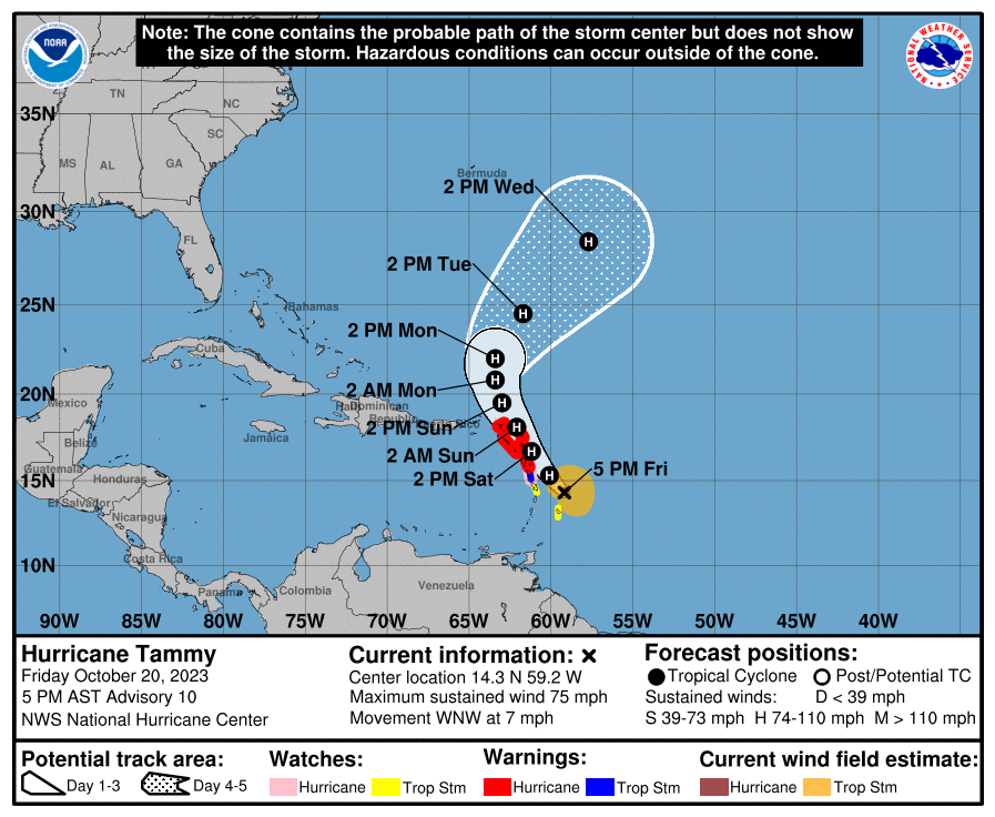
According to the latest advisory from the NHC, Tammy was a hurricane with maximum sustained winds of 75 mph about 125 miles east-southeast of Martinique and about 200 miles southeast of Guadeloupe. The storm was moving slowly at 7 mph to the west-northwest while the estimated minimum central pressure was 991 mb or 29.27″.
Hurricane Warnings are now in effect for Guadeloupe, Antigua, Barbuda, Montserrat, St. Kitts, Nevis, Anguilla, St. Maarten, St. Martin, and St. Barthelemy. A Hurricane Watch is in effect for Dominica. A Hurricane Warning means that hurricane conditions are expected somewhere within the warning area, in this case within the next 24 hours. Preparations to protect life and property should be rushed to completion. A Hurricane Watch means that hurricane conditions are possible within the watch area, in this case within the next 24 hours.
A Tropical Storm Warning is in effect for Dominica and Saba and St. Eustatius. A Tropical Storm Watch is in effect for Barbados and Martinique. A Tropical Storm Warning means that tropical storm conditions are expected somewhere within the warning area. A Tropical Storm Watch means that tropical storm conditions are possible within the watch area.
According to the NHC, Tammy is expected to turn towards the northwest tonight followed by a north-northwestward and northward turn Saturday night through Sunday night. On the forecast track, the center of Tammy will move near or over portions of the Leeward Islands tonight through Saturday night, and then move north of the northern Leeward Islands on Sunday.
The NHC says gradual strengthening is forecast during the next couple of days, and Tammy is expected to be a hurricane while it moves near or over portions of the Leeward Islands.
For now, hurricane-force winds extend outward up to 25 miles from the center and tropical-storm-force winds extend outward up to 125 miles.
Tropical storm-force wind conditions are expected within the tropical storm warning area beginning tonight. Hurricane conditions are expected in the hurricane warning area by late tonight or early Saturday. Hurricane conditions are possible in the hurricane watch area in the Leeward Islands on Saturday. Tropical storm conditions are possible within the tropical storm watch area beginning tonight.
Very heavy rain will fall from Tammy. The Leeward Islands will see 4-8″ with isolated amounts of 12″; the Northern Windward Islands can see 2-4″ with isolated amounts fo 6″. Eastern Puerto Rico and the U.S. and British Virgin Islands could also see soaking rains; there, 1-2″ is expected with isolated amounts up to 4″, especially in areas of higher terrain.
Tammy is forecast to produce a storm surge, which could raise water levels by as much as 1 to 3 feet above normal tide levels near where the center of Tammy moves across the Leeward Islands. Near the coast, the surge will be accompanied by large and dangerous waves.
Swells generated by Tammy will continue to affect portions of the Lesser Antilles during the next few days. These swells are likely to cause life-threatening surf and rip current conditions. Even experienced swimmers and surfers should avoid the ocean until the hazardous seas have calmed.
