Hurricane Warnings are up ahead of what is expected to be the landfall of Major Hurricane Laura which is now forecast to impact the central Gulf of Mexico coast at least as a Category 3 hurricane on the Saffir-Simpson wind scale. A life threatening storm surge and an area of destructive winds are expected to move on-shore later tomorrow into Thursday. With time, the storm will move across the eastern United States, perhaps picking up some intensity as it moves through the Mid Atlantic on the weekend.
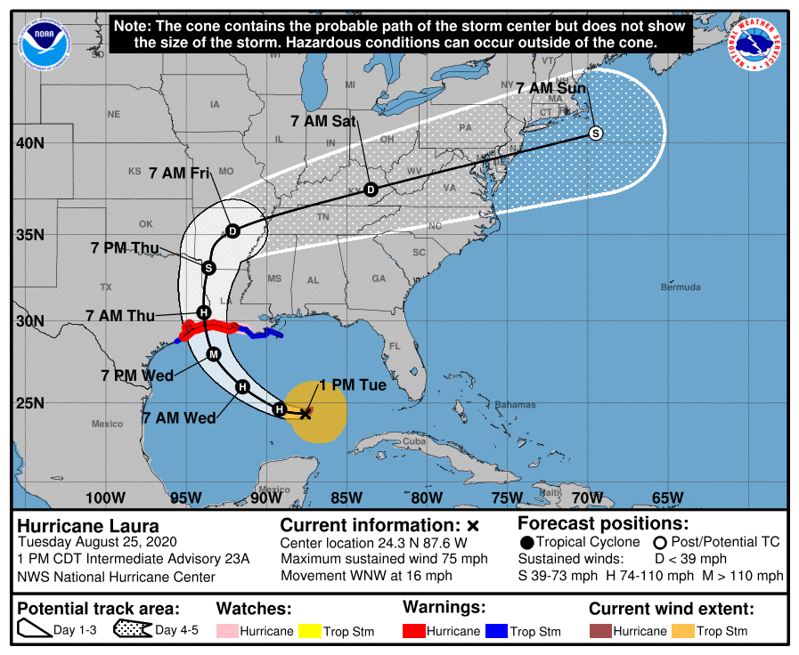
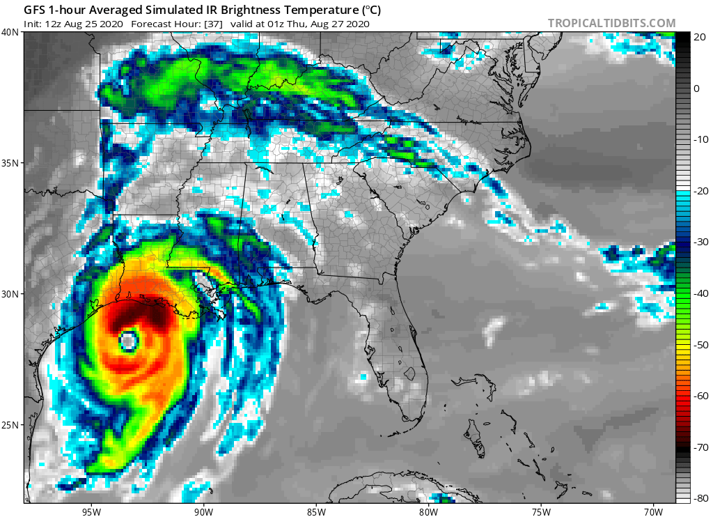
As of the 1pm CT update from the Miami, Florida – based National Hurricane Center (NHC), Hurricane Laura was located about 525 miles southeast of Lake Charles, Louisiana and about 560 miles southeast of Galveston, Texas. Laura had a minimum central pressure of 990 mb or 29.24 inches and maximum sustained winds of 75 mph.
Now that Laura is located in the Gulf of Mexico where this is rich heat energy to tap into and limited atmospheric sheer to disturb the storm, the NHC expects Laura to begin the rapid intensification process which will increase the intensity of Laura from the Category 1 hurricane it is now to at least a Category 3 hurricane when it strikes land.
A variety of warnings and watches are in effect ahead of Laura’s arrival. A Storm Surge Warning is in effect from San Luis Pass, Texas to the Mouth of the Mississippi River. A Hurricane Warning is in effect from San Luis Pass, Texas to Intracoastal City, Louisiana. A Tropical Storm Warning is in effect from Sargent, Texas to San Luis Pass, Texas and from east of Intracoastal City, Louisiana to the Mouth of the Mississippi River. A Storm Surge Watch is in effect from Freeport, Texas to San Luis Pass, Texas, and from the Mouth of the Mississippi River to Ocean Springs, Mississippi. Lake Pontchartrain, Lake Maurepas, and Lake Borgne are alsounder a Storm Surge Watch. A Hurricane Watch is in effect for the area east of Intracoastal City to west of Morgan City, Louisiana.
Each watch and warning has a different meaning. A Storm Surge Warning means there is a danger of life-threatening inundation, from rising water moving inland from the coastline, during the next 36 hours in the indicated locations. The National Hurricane Center warns, “This is a life-threatening situation. Persons located within these areas should take all necessary actions to protect life and property from rising water and the potential for other dangerous conditions. Promptly follow evacuation and other instructions from local officials.” A Hurricane Warning means that hurricane conditions are expected somewhere within the warning area. A warning is typically issued 36 hours before the anticipated first occurrence of tropical-storm-force winds, conditions that make outside preparations difficult or dangerous. Preparations to protect life and property should be rushed to completion. A Storm Surge Watch means there is a possibility of life-threatening inundation, from rising water moving inland from the
coastline. A Hurricane Watch means that hurricane conditions are possible within the watch area. A watch is typically issued 48 hours before the anticipated first occurrence of tropical-storm-force winds, conditions that make outside preparations difficult or dangerous. A Tropical Storm Warning means that tropical storm conditions are expected somewhere within the warning area.
Laura is moving toward the west-northwest near 16 mph and this general motion should continue today. A turn toward the northwest is forecast by Wednesday by the NHC, and a northwestward to north-northwestward motion should continue through Wednesday night. On the forecast track, the center of Laura will move across the southeastern Gulf of Mexico today. Laura is then forecast to move over the central and northwestern Gulf of Mexico tonight and Wednesday, approach the Upper Texas and Southwest Louisiana coasts on Wednesday night and move inland near those area on Thursday.
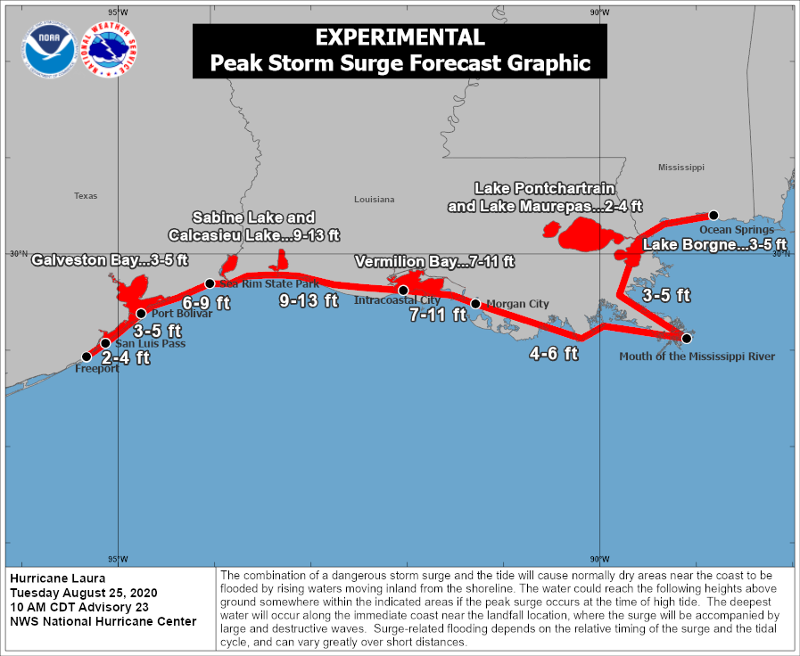
The most severe impacts from Major Hurricane Laura will be the storm surge flooding and the damaging winds.
The combination of a dangerous storm surge and the tide will cause normally dry areas near the coast to be flooded by
rising waters moving inland from the shoreline. The water could reach the following heights above ground somewhere in the indicated areas if the peak surge occurs at the time of high tide:
- Sea Rim State Park, Texas to Intracoastal City, Louisiana including Sabine Lake
& Calcasieu Lake: 9-13′ - Intracoastal City to Morgan City including Vermilion Bay: 7-11′
- Port Bolivar, Texas to Sea Rim State Park: 6-9′
- Morgan City, Louisana to the Mouth of the Mississippi River: 4-6′
- San Luis Pass, Texas to Port Bolivar: 3-5′
- Galveston Bay: 3-5′
- Freeport, Texas to San Luis Pass: 2-4′
- The Mouth of the Mississippi River to Ocean Springs, Mississippi including Lake Borgne: 3-5′
- Lake Pontchartrain and Lake Maurepas: 2-4′
The deepest water will occur along the immediate coast near and to the right of the landfall location, where the surge will be accompanied by large and destructive waves. Surge-related flooding depends on the relative timing of the surge and the tidal cycle, and can vary greatly over short distances.
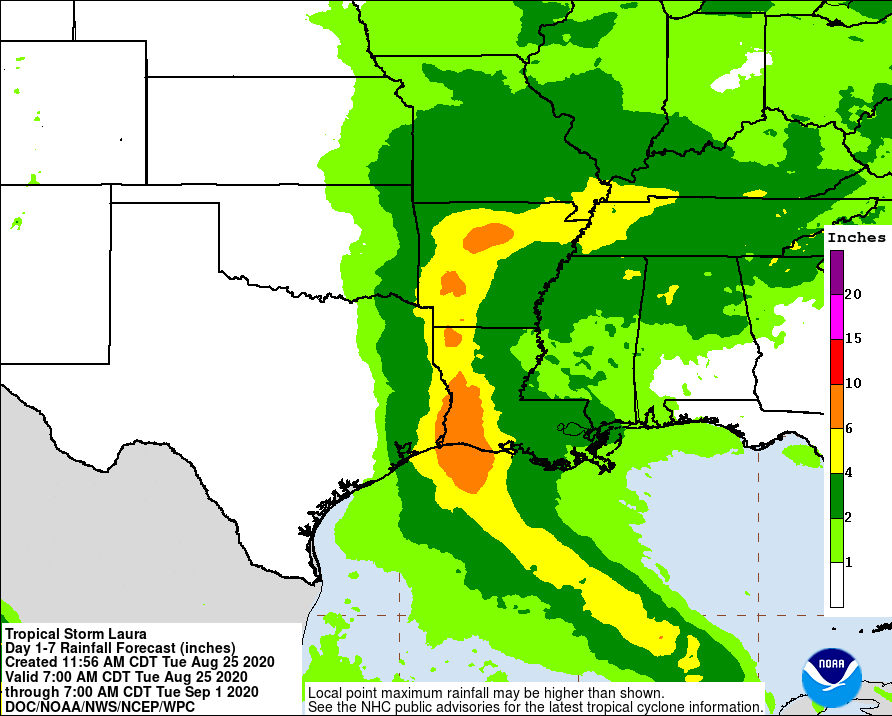
From Wednesday night into Saturday, Laura is expected to produce rainfall of 4-8″, with isolated maximum amounts of 12″ possible across portions of the west-central U.S. Gulf Coast from western Louisiana into east Texas, and northward into portions of the lower to middle Mississippi Valley, lower Ohio Valley, and Tennessee Valley. This rainfall will cause widespread flash and urban flooding, small streams to overflow their banks, and minor to isolated moderate river flooding.
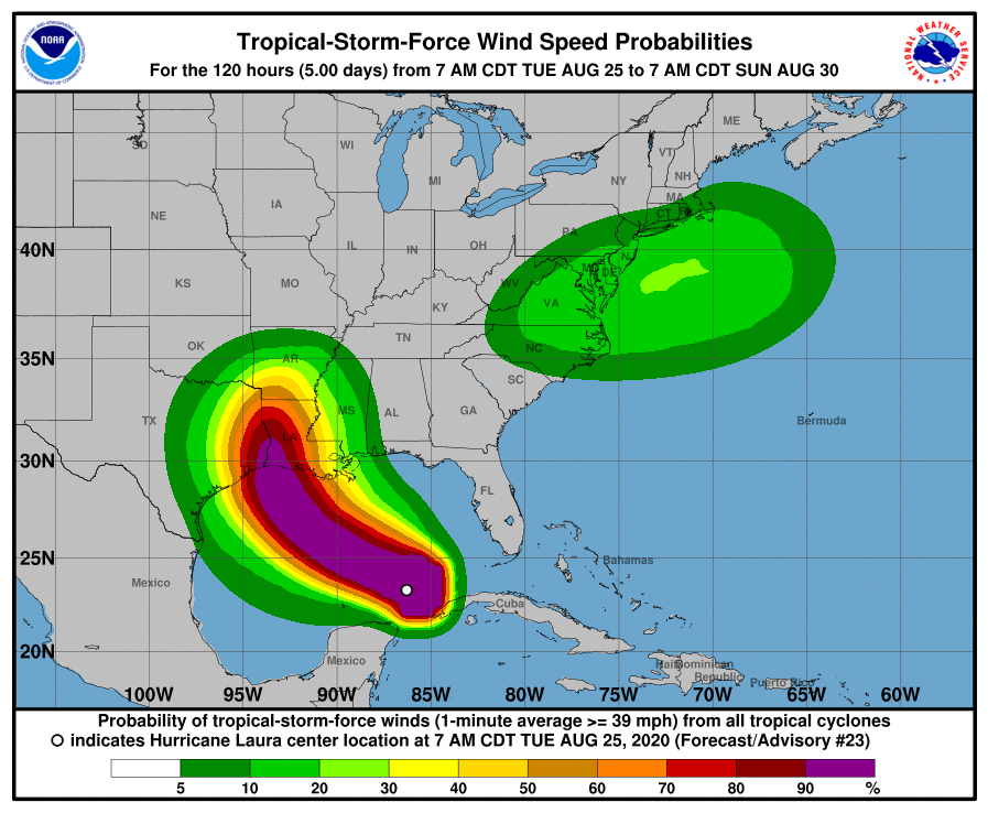
Hurricane-force wind conditions are expected in the hurricane warning area Wednesday night and Thursday. Tropical Storm conditions are expected to reach the coast in the hurricane warning area late Wednesday or Wednesday night, and are expected in the tropical storm warning area Wednesday night and Thursday.
Over time, Laura is expected to weaken as it moves north and eventually east through the Ohio Valley. Along the way, it will continue to drop very heavy rain over both the Mississippi and Ohio Valleys.
However, as Laura approaches the U.S. East Coast, it may be able to tap into energy in the atmosphere and the jet stream to intensify as it moves through the Mid Atlantic. As such, tropical storm force winds could be possible over portions of the eastern U.S. that saw them with Isaias just weeks ago. The National Hurricane Center believes Laura will transform to a subtropical or post-tropical storm here, with more heavy rain and damaging winds possible over the weekend. How that situation evolves will be determined by the strength and speed of Laura as it makes its way into the Gulf Coast and by how the weather pattern will shake-out after a cold front moves through the northeast today and tomorrow. Impacts for the Mid Atlantic will be refined over time.
