The National Hurricane Center has issued Hurricane and Tropical Storm Watches along the southeast coast of the United States as Subtropical Storm Nicole takes shape; the system is forecast to become a hurricane and threaten a large part of the east coast with torrential rains, storm surge flooding, and damaging winds.
Right now, Nicole is a Subtropical Storm with maximum sustained winds of 45 mph. The storm has a minimum central pressure of 1002 mb or 29.59″; it is moving to the northwest at 9 mph.
Ahead of Nicole’s arrival, the National Hurricane Center has issued a Hurricane Watch for the east coast of Florida from the Volusia/Brevard County Line to Hallandale Beach and for Lake Okeechobee. A Storm Surge Watch has also been issued for the east coast of Georgia and east coast of Florida from Altamaha Sound southward to Hallandale Beach. The government of the Bahamas has changed the Tropical Storm Watch that was in effect there to a Hurricane Watch for the northwestern Bahamas. Lastly, a Tropical Storm Watch has been issued for Altamaha Sound, Georgia southward to Volusia/Brevard County Line and south of Hallandale Beach to north of Ocean Reef.
Each watch carries a different meaning. A Tropical Storm Watch means that tropical storm conditions are possible within the watch area, generally within 48 hours. A Hurricane Watch means that hurricane conditions are possible within the watch area. A watch is typically issued 48 hours before the anticipated first occurrence of tropical-storm-force winds, conditions that make outside preparations difficult or dangerous.
The National Hurricane Center is warning that additional watches will likely be required later today.
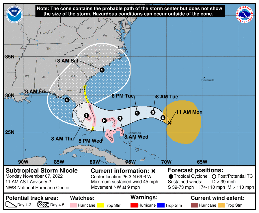
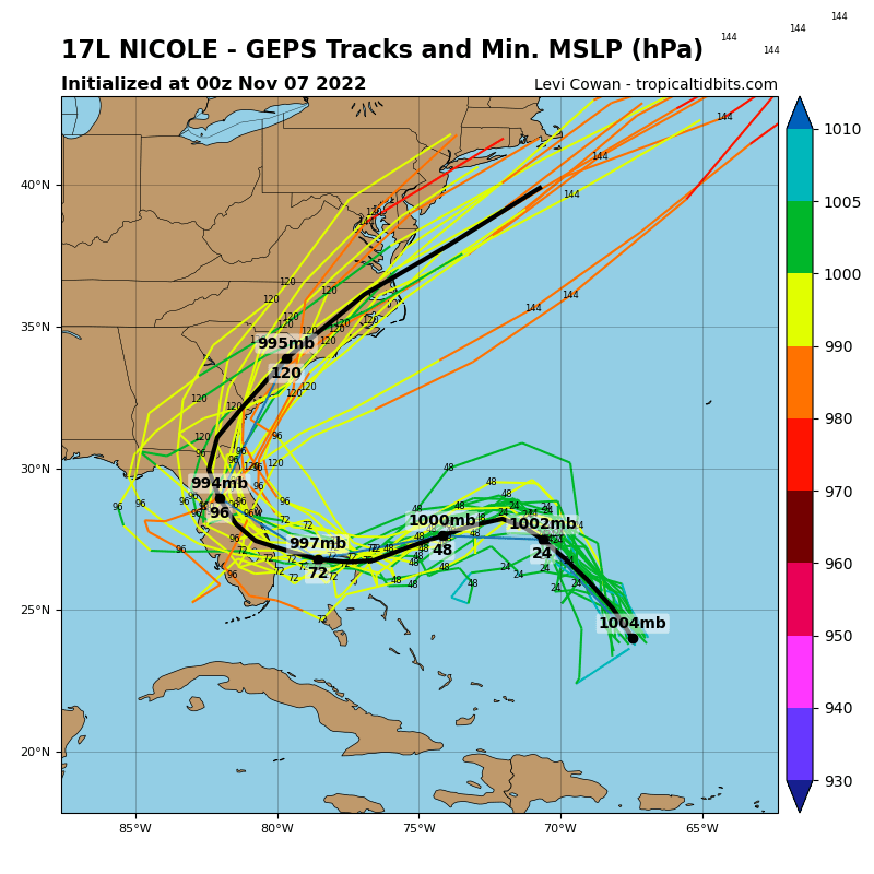
The National Hurricane Center doesn’t expect Nicole to move in a straight line; instead, it is expected to curve around and strike portions of Florida and the U.S. east coast on a curved path. While Nicole is moving to the northwest now, the National Hurricane Center expects a decrease in forward speed is expected later today. A turn westward or west-southwestward is then forecast Tuesday through early Thursday. On the forecast track, the center of Nicole will approach the northwestern Bahamas on Tuesday, move near or over those islands on Wednesday, and approach the east coast of Florida by Wednesday night. The National Hurricane Center also believes it is possible Nicole will re-enter the water on Florida’s west Gulf coast before coming back across the state and into the Atlantic coast by the end of the week. From there, computer models are conflicted with just how far inland or out to sea the storm travels.
While maximum sustained winds are near 45 mph with higher gusts now, the National Hurricane Center says that gradual strengthening is forecast during the next few days, and Nicole is forecast to be at hurricane intensity by Wednesday or Wednesday night while it is moving near or over the northwestern Bahamas.
In addition to being a strong storm, Nicole is a very large storm and is forecast to become even larger. Winds of 40 mph extend outward up to 275 miles from the center at this time.
As Nicole approaches the coast, it will bring threats of damaging wind, storm surge, and fresh water flooding.
Hurricane-force wind conditions are possible within the watch area in the northwest Bahamas by early Wednesday, with tropical storm conditions possible by Tuesday night. Hurricane conditions are possible within the watch area in Florida by Wednesday night with tropical storm conditions possible by Tuesday night.
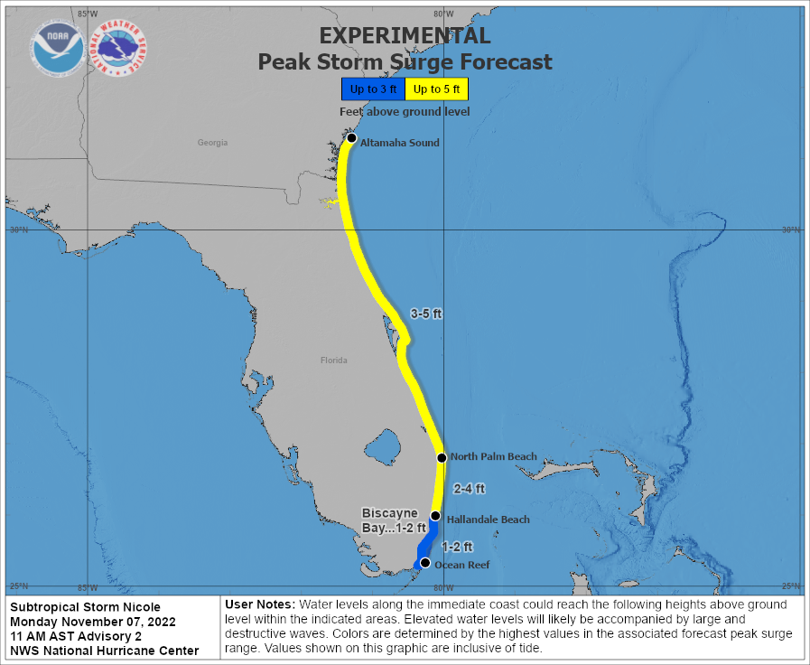
The combination of a dangerous storm surge and the tide will cause normally dry areas near the coast to be flooded by rising waters moving inland from the shoreline. The water could reach the following heights above ground if the peak surge occurs at the time of high tide:
- North Palm Beach to Altamaha Sound including the St. Johns River to the Fuller Warren Bridge: 3-5′
Hallandale Beach to North Palm Beach: 2-4′ - North of Ocean Reef to Hallandale Beach including Biscayne Bay: 1-2′
- Northwestern Bahamas in areas of onshore winds: 3-5′
The deepest water will occur along the immediate coast near and to the north of the landfall location, where the surge will be accompanied by large and destructive waves. Surge-related flooding depends on the relative timing of the surge and the tidal cycle, and can vary greatly over short distances. This is also a time period with significant lunar high tides which may worsen storm surge and coastal flooding this week.
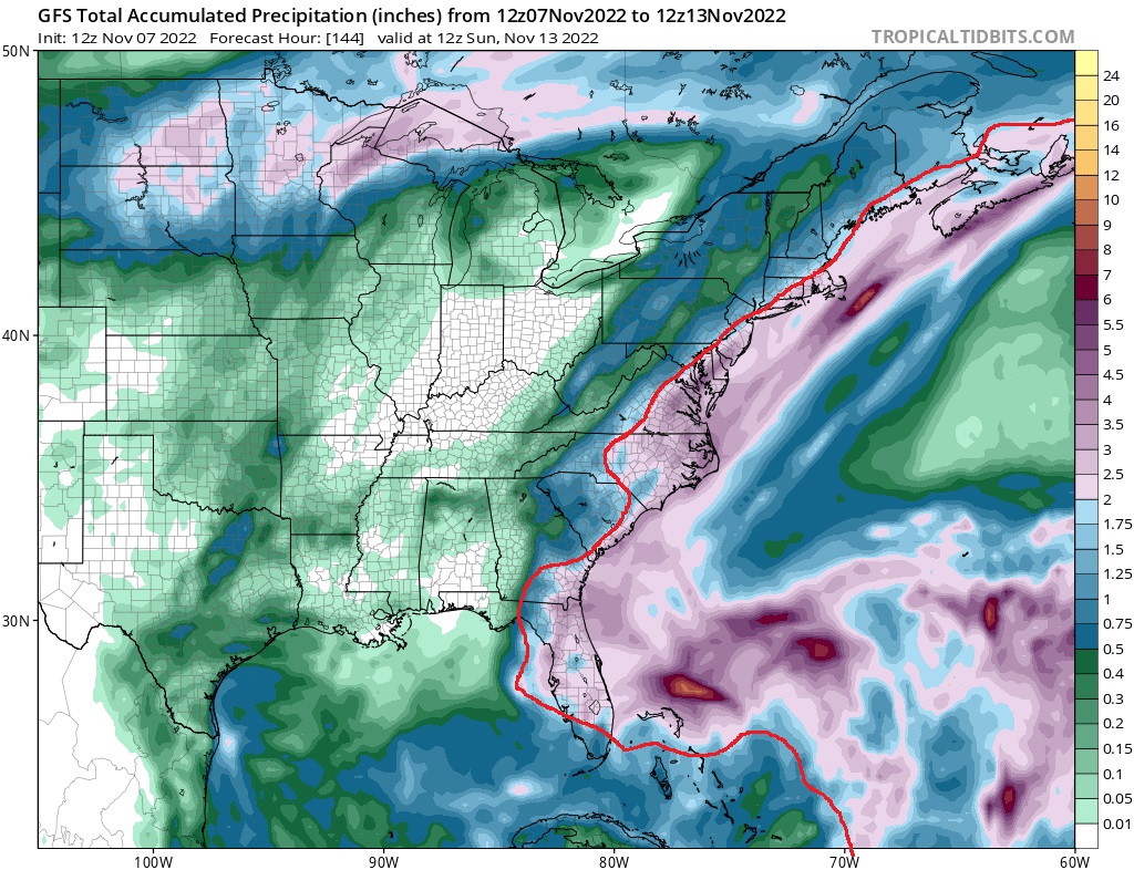
Nicole is forecast to dump heavy rain along its path. Across the northwest Bahamas, and the central and northern portions of the Florida Peninsula, 2-4″ of rain with localized amounts up to 6″ are possible. Heavy rainfall from this system will spread north across the Southeast United States late this week and flooding could be problematic even for portions of the Mid Atlantic and coastal New England.
