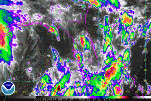
While a catastrophe is imminent in Texas as Major Hurricane Harvey approaches, Irma could be on the way along the US east coast. A broad area of low pressure located near the west-central coast of the Florida peninsula is producing a large area of disorganized cloudiness and thunderstorms over southern and central Florida and the adjacent waters. This system is forecast to move northeastward and emerge over the western Atlantic over the weekend where some development is expected through early next week before it merges with a front. Regardless of development, very heavy rain and flooding is possible over portions of southern and central Florida, and the northwestern Bahamas during the next few days. In addition, this system is expected to cause increasing northeast winds and rough surf along the coast of Georgia and the Carolinas through early next week.
Afternoon forecast guidance has become more bullish with the future intensity of this storm, suggesting that it could develop into a tropical storm or hurricane in the coming days. Once and if this system becomes a tropical storm, it would be named Irma. While a frontal system should help push it along out to sea, some guidance suggests a much closer track towards the coast, with some calling for a possible landfall over time in the northeastern United States. It is too soon to put much weight in such a forecast solution, but it is not too soon to be prepared in case it is right.
People along any Gulf or Atlantic coastline, and Hawaii, should be prepared every hurricane season; with Harvey here, people should ensure they are ready for the arrival of a potential disaster wherever they may be. With the potential of Irma on the US East Coast, it is important that people even in the Mid Atlantic and New England be prepared should Irma become more of a concern next week.
Experts believe this Atlantic Hurricane Season, which runs through to the end of November, will be a busy one. Dr. Phil Klotzbach and the experts at Colorado State University updated their seasonal outlook again on July 5, showing a much more active than normal season expected. The National Oceanic and Atmospheric Administration (NOAA) also released their own forecast which shows this hurricane season to be likely more active than others.