An all-out blizzard is impacting Kansas now and a fresh blizzard may impact New Jersey and portions of the east coast next weekend.
A major winter storm will move eastward from the Central Plains into the Ohio Valley and Mid-Atlantic region tonight, bringing areas of snow, sleet, freezing rain and gusty winds along its path. Gusty winds, locally exceeding 40 mph, will create blizzard conditions from Kansas into northwestern Missouri through this evening, with conditions improving from west to east overnight tonight. Areas of heavy snow will spread eastward through the Ohio Valley and central Appalachians tonight, reaching the Mid-Atlantic by Monday morning. While winds will be weaker across the Ohio Valley and Mid-Atlantic region, occasional gusts up to 20-25 mph will still be possible which will result in reduced visibilities from snowfall or snow on the ground.
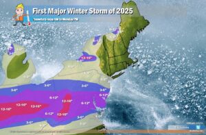
Total snowfall accumulations of 6-12″ are expected from southern Ohio to the D.C. metropolitan area with less amounts north; little if any accumulating snow is expected in New York City. South of the snow will be a mixture of sleet and freezing rain with damaging ice accumulations which are expected to exceed 0.25″ for northern Kentucky and portions of southern West Virginia. Lighter, but still hazardous ice accumulations generally between 0.10-0.25″ are expected along and east of the Blue Ridge Mountains into western North Carolina and central/southern Virginia.
On the warm side of the storm system, severe thunderstorms capable of producing tornadoes and damaging straight line winds will move east from Arkansas and Louisiana into Mississippi and Alabama this evening. The threat for severe thunderstorms is expected to wane overnight but increase again for portions of southern Georgia and northern Florida on Monday, though the threat is expected to be reduced compared to the Lower Mississippi Valley.
The eastern storm system will exit quickly into the western Atlantic Monday night with lingering snow showers downwind of the Great Lakes and into the favored upslope regions of the central/northern Appalachians. Much colder air will filter into the central and eastern U.S. in the wake of the eastern storm system resulting in high temperature departures of roughly 10 to 20 degrees below average for large portions of the Great Plains to the East Coast on Monday and Tuesday.
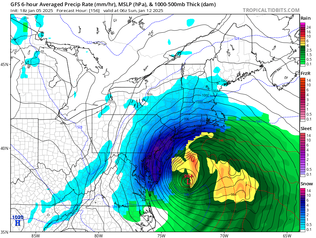
This surge of new cold air will set the stage for a new storm system to form later in the week. Forecast models used by meteorologists to aid with their weather forecasting have been suggesting the possibility that a storm system will explode into a “blizzard bomb” and bring heavy snow whipped by strong winds to portions of the northeast.
While the phrase “blizzard bomb” sounds like meteorological hyperbole, the words are actual meteorological terms with scientific definitions. The storm system responsible for the blizzard bomb will be just that: an area of low pressure that is due to meteorologically “bomb” while blizzard criteria is expected to be reached over a rather broad area. A “bombing” low pressure system is one that meets criteria of a rapidly deepening low pressure system; pressure needs to drop at least 24 mb in 24 hours to be considered “bombing.”

While many people think a blizzard is simply a big snowstorm, they’re wrong. A blizzard is all about wind and visibility. According to the National Weather Service, three criteria must be reached before a storm is considered a blizzard. First, there needs to be sustained winds of 35 mph or frequent gusts over 35 mph. Second, due to the weather, the visibility must be reduced to 1/4 mile or less. This reduction can happen from falling heavy snow …or it could simply be previously fallen snow blowing about in the wind. You do not need fresh snow to be falling to reach blizzard criteria. Third, to count as a blizzard, the reduction in visibility and the strong winds must last for at least three hours. When all three of these conditions are met, you have more than a snowstorm: you have a full-fledged blizzard!
The GFS and ECMWF are among many computer models meteorologists use to assist in weather forecasting. While meteorologists have many tools at their disposal to create weather forecasts, two primary global forecast models they do use are the ECMWF from Europe and the GFS from the United States. While the models share a lot of the same initial data, they differ with how they digest that data and compute possible outcomes. One is better than the other in some scenarios, while the opposite is true in others. No model is “right” all the time. Beyond the ECMWF and GFS models, there are numerous other models from other countries, other academic institutions, and private industry that are also considered when making a forecast.
Right now, both these global models continue to forecast an east coast storm taking shape. Most of the recent GFS runs continue to call for a blizzard or a bomb blizzard while the ECMWF is much weaker. Which one will be right is anyone’s guess for now; it is simply too soon to say how this next storm will unfold until the current storm impacting the U.S. moves through.
