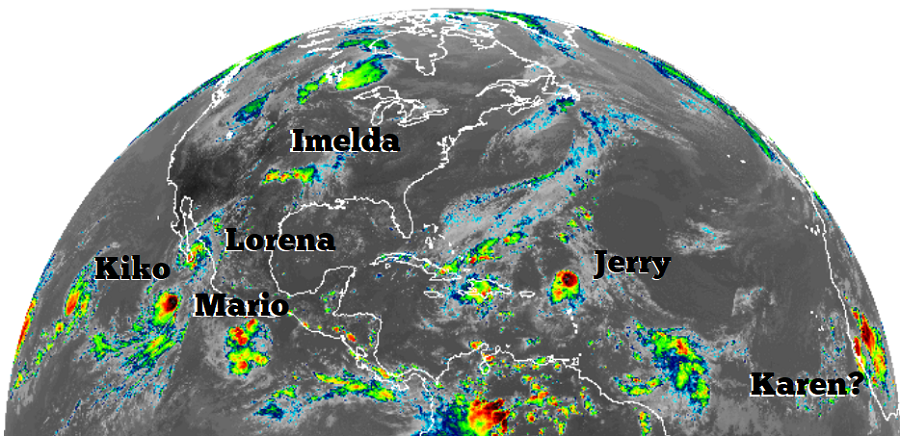
Meteorologists at the National Hurricane Center (NHC) in Miami, Florida are busy tracking numerous systems in the Pacific and Atlantic. Hurricane Lorena and Tropical Storms Kiko and Mario are in the Pacific while Hurricane Jerry is in the Atlantic; it is also likely that Karen is forming over western Africa. Of the bunch, Kiko is the greatest threat to the United States for now.
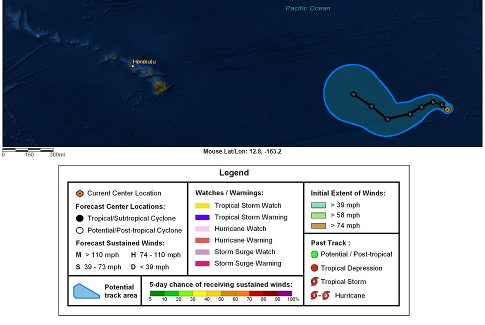
In the latest advisory from the NHC, the center of Tropical Storm Kiko was located near latitude 17.9 North, longitude 130.8 West. Kiko is moving toward the northwest near 6 mph. According to the NHC, a turn toward the west is expected tonight, followed by a turn toward the west-southwest over the weekend. Maximum sustained winds are near 60 mph with higher gusts. Little change in strength is forecast for the next several days. Tropical-storm-force winds extend outward up to 45 miles from the center. The estimated minimum central pressure is 999 mb or 29.50 inches. For now, Kiko is over open waters of the Pacific far away from landmass between Mexico and Hawaii. However, some medium range forecast guidance suggests Kiko or its remnants may make their way towards Hawaii later next week. It is still too early to say with certainty what direct or indirect impacts, if any, Hawaii could see from Kiko.
In the Atlantic, tropical storm conditions are impacting portions of the Leeward Islands. While the government of the Netherlands has discontinued the Tropical Storm Watch for Saba and St. Eustatius, a Tropical Storm Watch remains in effect for St. Maarten, St. Martin, and St. Barthelemy. A Tropical Storm Watch means that tropical storm conditions are possible within the watch area, in this case within 12 hours.
As of the latest advisory from the NHC, the center of Hurricane Jerry was located near latitude 19.6 North, longitude 62.0 West. Jerry is moving toward the west-northwest near 18 mph . On the forecast track, the center of Jerry will move north of the northern Leeward Islands later today, pass well north of Puerto Rico on Saturday, be well east-northeast of the southeastern Bahamas on Sunday and turn northward on Monday. Maximum sustained winds remain near 80 mph with higher gusts. Some weakening is forecast overnight, but according to the NHC, Jerry could re-strengthen early next week. Hurricane-force winds extend outward up to 15 miles from the center, and tropical-storm-force winds extend outward up to 90 miles. The estimated minimum central pressure is 991 mb or 29.27 inches. Jerry is expected to produce 1 to 3 inches of rainfall, with isolated maximum totals of 4 to 6 inches from Barbuda northwest across St. Maarten, Anguilla, and Anegada. This rainfall may produce life-threatening flash floods. Jerry is also forecast to produce total rainfall accumulations of 1 to 2 inches with maximum amounts of 3 inches across the Virgin Islands and Puerto Rico. Tropical storm conditions are possible within the watch areas this evening. Swells generated by Jerry are affecting portions of the northern Leeward Islands. These swells are likely to cause life-threatening surf and rip current conditions.
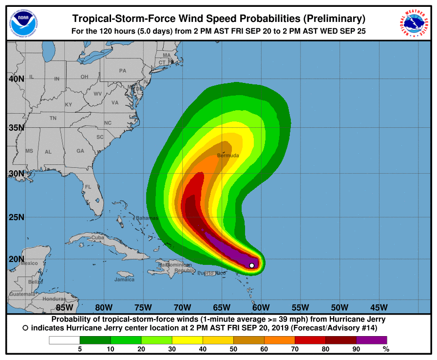
On its current forecast track from the NHC, Jerry is expected to curve away from the United States in the Atlantic, potentially impacting Bermuda as it heads north and east over time. Even though people are cleaning up after Humberto there, it is important for people to monitor Jerry’s future progress on Bermuda.
In addition to these named storms, a tropical wave is forecast to move off the west coast of Africa this weekend. Environmental conditions are expected to be conducive for development, and a tropical depression or tropical storm is likely to form early next week while the wave moves westward across
the eastern tropical Atlantic. As of this afternoon’s Tropical Outlook, the NHC believes there’s a 70% chance that a tropical cyclone will form here over the next 5 days. Should this system strengthen into a tropical storm or stronger, it would be named Karen.
