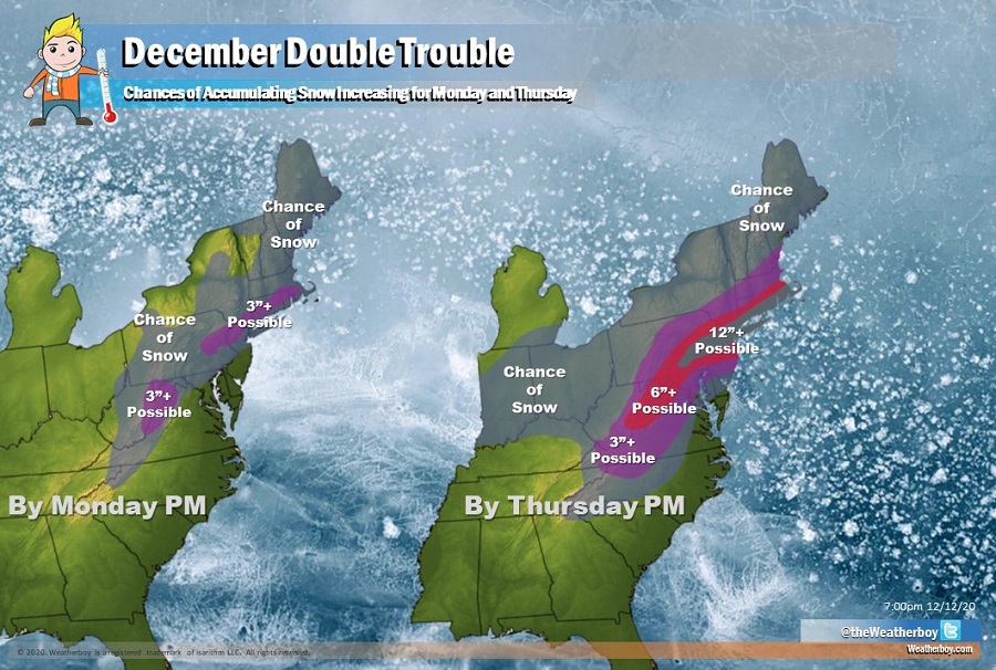
The largest snowstorm to strike portions of the Mid Atlantic and New England is likely this week, with more than 20″ of snow possible. Confidence continues to grow that a high-impact coastal storm will impact the region Wednesday into Thursday, bringing wind-whipped rain and snow across a large area. Enough cold air should be wrapped up into this storm to create very significant, heavy snow for areas that have seen very little snow in recent years.
While a weaker system will move through the region on Monday bringing lighter precipitation, mainly in liquid form, the blockbuster storm is expected to unfold Tuesday through Thursday with the peak of the storm late Wednesday night. Over the southern U.S. on Tuesday and Tuesday night, a southern stream shortwave will move east from Texas. A surface low pressure system will develop near the northern Gulf coast by Wednesday morning. Meanwhile, a cold Arctic high pressure system will be building south and east from Quebec on Tuesday. By Wednesday, the southern storm will move north and east toward Virginia and North Carolina by the afternoon hours. This storm evolution will occur as the shortwave driving it starts to take on a more negative tilt.
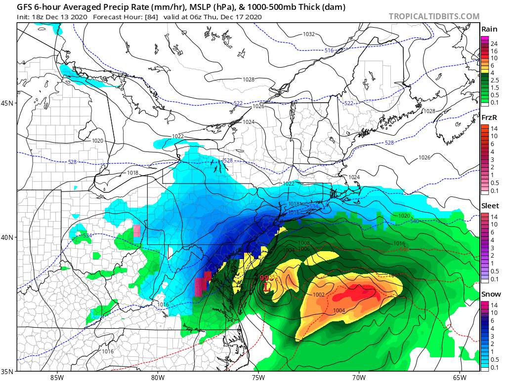
While the precise storm track is still not yet known, and it’ll be that final track that determines precipitation amounts and types, it appears the center of the potent storm will move south of the east coast of Maryland and then east-northeast off of the Jersey Shore through Wednesday night. From there, the storm will head more east than northeast, sparing northern New England from significant precipitation.
Right now, it appears the heaviest snow will fall over and to the north and west of the I-95 corridor between Baltimore, MD and New York City, NY. The heaviest snow could fall in eastern Pennsylvania west and north of Philadelphia, where snow could be measured in feet rather than inches. In the big I-95 cities of Baltimore, Philadelphia, and New York, there are good odds that 10″ or more of snow could fall. However, exact precipitation amount and types will be refined in the next 48 hours as more data is interpreted by meteorologists tracking the storm.
Strong northeast winds associated with this coastal storm will be another severe weather threat Wednesday into Thursday. Northeast winds gusting 40 to 50 mph or greater are possible along the coast. Winds of this magnitude can create power outages and do some minor damage to homes and landscaping. Gusty winds will reach as far inland as the I-95 corridor from this storm and could extend further inland depending on the track and intensity of the storm.
At the coast, coastal flooding and beach erosion will also be possible as strong winds, rough surf, and heavy precipitation strikes coastal plain. Those in areas prone to coastal flooding in Delaware, New Jersey, and New York should prepare now for that threat.
South of the snow, heavy rain will fall. In between the snow/rain area, an icy mix of sleet and freezing rain are possible too. There could be localized flooding from the heavy rain, especially on the central Mid Atlantic coast.
Eventually, high pressure will return to the region later Thursday, ending the snow and giving people a chance to shovel and plow out. The government warns people that threats associated with the ongoing COVID pandemic don’t end with the snow: social distancing, mask wearing, and good hygiene are still required to keep people healthy, even in the aftermath of a snowstorm.
