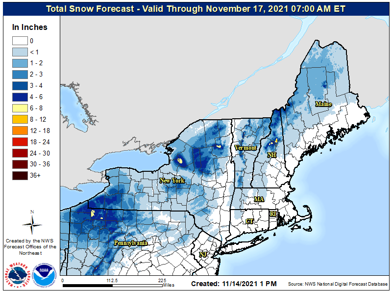
A weather system known as a “clipper” will push through the northeast tonight and tomorrow, bringing a round of likely light snow across the northeast from Pennsylvania to Maine. Snow will generally be light, although there could be pockets of snow greater than 4″ over northwestern Pennsylvania, north central Upstate New York, and the higher elevations of New Hampshire.
A clipper is a fast moving low pressure system that moves southeast out of the Canadian provinces of Alberta and Saskatchewan in southwest Canada through the Plains, Midwest, and Great Lakes region usually during the winter. This low pressure area is usually accompanied by light snow, strong winds, and colder temperatures. Clippers that come from Alberta are known as “Alberta Clippers” while storms that originate in Saskatchewan are known as “Saskatchewan Screamers”.
The upper level low that brought severe weather such as accumulating hail, damaging wind gusts, and waterspouts and tornadoes to the region on Saturday is currently exiting the Canadian Maritimes with another potent low entering the Great Lakes region now. At the surface, a clipper-like area of low pressure will pass from the southern Great Lakes throughout the day and eventually off the New England coast on Monday. According to the National Weather Service, a stratiform shield of light precip is expected to develop and overspread portions of the Northeast and Mid Atlantic southwest to northeast starting this evening, with most precipitation exiting between midnight and sunrise tomorrow.
This system is starved for moisture. Light rain is likely to fall over the I-95 corridor between Philadelphia and Boston, including the New York City area where temperatures will be too mild to support any frozen precipitation. However, the thermal profile of the atmosphere will support mostly snow in the higher elevations of the Poconos, northwest New Jersey, and points north. Given the overnight timing of the precipitation, snow is likely to accumulate where the temperature is near or below freezing, especially on grassy and elevated surfaces. Generally around an inch or less is expected over a broad area, but some areas like higher terrain areas of interior New England that usually see more snow will see somewhat heavier amounts.
By Monday morning, the system will be moving offshore, allowing for cold air advection to take over in its wake. High pressure will build into the Southeast as the surface low departs offshore, producing chilly and breezy conditions throughout the northeast.
