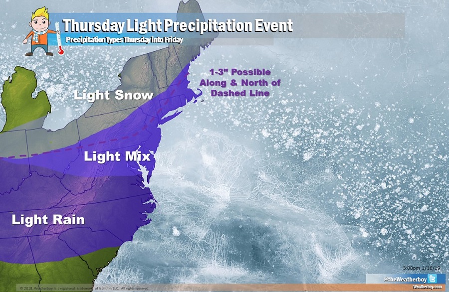
Thursday will be messy with light snow to the north, light rain to the south, and snow changing to rain and/or rain changing to snow in the middle. 1-3″ of snow is possible on the northern side of this storm, making it more of a nuisance event than a major winter storm. A different kind of storm with different kind of results remains on the table for the weekend.
Warm advection and associated atmospheric lift will approach the Mid Atlantic and Northeast late tonight, resulting in an increase in cloudiness during the late night hours. The presence of clouds will shut-down any cooling process in the east; if temperatures don’t drop below freezing before the clouds arrive, it is likely that area will see plain rain on Thursday.
On Thursday, as the southern periphery of a closed low in southern Canada weakens, a more zonal flow is expected in the eastern U.S. A short wave trough will move east from the mid-Mississippi Valley Thursday, weakening as it does so. A
weak surface low associated with the short wave trough will move through southern New England later Thursday night into Friday, setting the stage for light precipitation. As the surface low departs to the north and east on Friday morning, precipitation will quickly wrap-up.
New England, especially locations away from the coast, will see light snow later Thursday from this system. Further south, marginal thermal profiles will produce light snow mixing with or changing to light rain or light rain mixing with or changing to light snow. Further south, from central West Virginia and Virginia south, only plain rain is expected throughout this light precipitation event.
With limited moisture to work with, snowfall amounts will be light, with light accumulations possible even in the wintry mix area before light rain washes it away or turns it to slush. Generally 1-3″ of snow is possible from central Ohio to central Pennsylvania to northern New Jersey to upstate New York to northwestern Connecticut, central Massachusetts, southern New Hampshire, and points north and west. While a dusting of snow is possible south of here, no significant accumulations are expected.
A more substantial storm system will impact this region on Sunday into Monday, producing the chance for heavy snow, accumulating ice, and/or heavy rain across a large part of the eastern United States.
