A common misconception about the weather in your yard is that it does not develop in your town, state, country or even continent. Instead, it is affected and shaped by conditions elsewhere across the globe.
Depending on where in the world that one is looking, it can take a matter of days, weeks or even months for your local weather to be changed and modified by what meteorologists call teleconnections. Teleconnections are defined as meteorological variables in locations that are separated by hundreds or even thousands of miles that are tied to one another. A famous teleconnection is the air pressure variation in the South Pacific that defines the El-Nino/La Nina phenomena. Another lesser-known teleconnection is the typhoon rule. This “rule” says a recurving typhoon in the western Pacific near Japan will be followed by a stormy weather pattern over the eastern U.S. in 6-10 days.

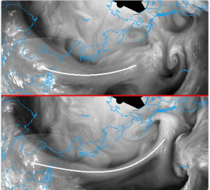
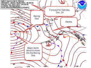
A highly reliable yet relatively unkown teleconnection is the Bering Sea Rule (BSR). This teleconnection says that what happens meteorologically in the Bering Sea (found northeast of Japan and east of Siberia) will be repeated in the eastern and central United States 17-21 days afterwards. This weather phenomena can give us a peek to what the weather will be in the three week or so time frame, which is meteorologically known as the medium range.
Joseph Renken, founder of the BSR, said, “Currently the Bering Sea is experiencing a very active period of weather, with one major storm there now and another expected to affect the region late this week.” Some of Mr. Renken’s credits include presenting the BSR to both National Conferences of the National Weather Association (NWA) and the American Meteorological Society (AMS), submitting two BSR research papers to the National Oceanic and Atmospheric Administration (NOAA) , and making numerous presentations to local chapters of the AMS. Renken has also provided advice to organizations such as the National Weather Service and private weather forecast firms with insights on how to utilize the BSR.

What does this mean for the beginning of 2017? As millions of people in the U.S. know, we have seen a series of Arctic blasts of air over the past 2 weeks. In the time period leading up to and after the Christmas holiday, a milder flow of air with its origins over the Pacific Ocean will seep west to east across the U.S., replacing the very cold air in place across the East and causing temperatures to first moderate and then get above normal in most areas. This general pattern of warmer than average weather will continue after Christmas and will likely last into early 2017.
Mr. Renken observed, “The BSR is currently running at a cycle length of about 17 days. After this period of time, the weather pattern in the central/eastern U.S. will mirror what is going on in the Bering Sea now. Expect a dip in the jet stream to develop over the central and eastern U.S. and the extended mild period will come to an end sometime very early in 2017.”
A major storm or two may accompany this pattern change, such as what we are currently seeing in the Bering Sea. The storm(s) exact path(s) may not be known, but we can expect wintry precipitation, heavy rain and high winds to be experienced in some areas. Mr. Renken added, “The cold air to follow these system(s) will not be long-lasting. Expect a back and forth period pattern of cold shots followed by warm ups with the end result of near normal temperatures over the first week or two of January for much of the Eastern and Central U.S.”