February ended on a deadly note with an ongoing severe weather threat kicking-off March on an equally dangerous tone.
A large weather system will bring dangerous conditions east today after claiming at least three lives last night. Widespread wind damage is forecast across parts of Kentucky and Tennessee this morning. Severe thunderstorms will continue to spread across the Ohio and Tennessee Valley regions into the Middle Atlantic states, possibly into southern New England by mid afternoon. Damaging winds are the primary severe threat, though a few tornadoes and hail will be possible, especially west of the Appalachians.
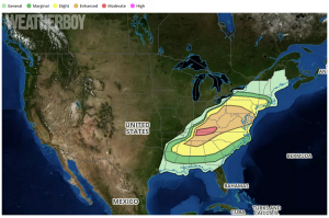
RADAR imagery early this morning shows an extensive squall line from the upper Ohio Valley southwestward into portions of west-central Kentucky and middle Tennessee. The southern portion of the squall line has had a several-hour history of widespread measured severe gusts as it tracked from eastern Arkansas into western Kentucky and Tennessee. A mesoscale convective vortex (MCV; it is a is a low-pressure center within an mesoscale convective system (MCS) that pulls winds into a circling pattern, or vortex. MCVs typically have a a core of about 30-60 miles wide and 1-3 miles deep) associated with this part of the line is forecast to move downstream within a belt of strong flow in the mid levels of the atmosphere. It seems likely the greatest concentration of severe gusts and swaths of wind damage will align from near the I-65 corridor in Tennessee/Kentucky to the spine of the Appalachians by late this morning , resulting in higher wind probabilities and a moderate risk of severe thunderstorm activity. It appears increasingly likely destabilization will not be inhibited by prior storm activity from the southern half of
West Virginia east-northeastward into the DC metro and and DelMarVa areas.

Storm-scale guidance moves a squall line into the I-95 corridor during the early afternoon coincident with appreciable diurnal destabilization and steepening of low-level lapse rates and becoming more favorable for momentum transfer. In addition to the risk for widespread damaging winds, the stronger/longer-lived mesovortices embedded within the line may yield a weak tornado risk. This threat exists in the I-95 corridor from Washington, DC north to the New York City metro area.
In wake of the early-day squall line over TN, additional storm development is possible across the TN Valley south of where convective overturning and significant stabilization has occurred. The strong wind profile will strongly favor storm organization. Hail, wind, and possibly some tornado risk could develop before upscale growth occurs across AL/GA with isolated damaging winds becoming the primary threat towards evening.
The threat of severe weather diminishes as you head north. Over the northern half of Pennsylvania into New York state and southern New England, destabilization this morning will likely be hindered appreciably as widespread cloud cover stunts surface heating. As the northern portions of the squall line over northwestern Pennsylvania and the upper Ohio Valley pushes eastward this morning, a corresponding risk for strong to possibly severe gusts may accompany the line.
The National Weather Service’s Storm Prediction Center categorizes these severe weather threats into 6 categories, displayed on our national map here. The light green area defines an area where thunderstorms are possible, but none are expected to reach severe limits. A lightning and flash flood threat exists nonetheless from any thunderstorm, and while not severe, there could be small hail and winds of up to 40mph here. The dark green area defines an an area of “Marginal” threat. Here, isolated severe storms are possible; while limited in duration, coverage, and/or intensity, they could contain winds in the 40-60mph range, hail up to 1″, and do have a low tornado risk. The yellow area defines an area of “Slight” threat; greater than marginal, this area features scattered severe thunderstorms. Here, short-lived and/or not widespread, isolated, intense storms are possible. Such storms may spawn a tornado or two and there could be many reports of damage from strong winds or large hail. Hail here is likely under 1″, but could reach up to 2″ in diameter. The orange area defines an area of “Enhanced” threat. The Enhanced threat zone is an area where numerous severe storms are possible. Here, they’ll be more persistent and/or widespread; a few could be intense. These storms will produce a few tornadoes, several reports of wind damage, and could produce damaging hail in the 1-2″ size range. The red “Moderate” risk zone is an area where widespread severe storms are likely. They could be long-lived and intense; these cells will produce strong tornadoes and significant, widespread wind damage. Destructive hail greater than 2″ is possible. An area not yet defined on today’s map is “High”; high is typically shaded in hot pink. The most dangerous of the risk categories, High shows an area where widespread severe storms are likely. Long-lived, widespread, and particularly intense storms are likely here. This area is where a tornado outbreak will occur and/or destruction from a derecho.
Tornadoes touched down in the upper Midwest and northern Arkansas on Tuesday, kicking off this current two-day violent weather spree. Compact but strong storms known as supercells raked parts of the central US, creating an area of damage that extended from Arkansas to Iowa and Illinois. On the southern side of the storm system, wind-whipped wildfires raged in Texas, destroying homes there.