Authorities in Florida have begun issuing mass evacuations while the National Hurricane Center in Miami, Florida now call for Idalia, currently a strong tropical storm, to rapidly intensify into a major category 3 storm on the Saffir-Simpson wind scale. Catastrophic storm surge flooding, destructive winds, flooding rains, and widespread tornadoes are possible as Idalia crosses Florida before threatening the rest of the southeast U.S. coast. Due to the expected storm impacts, local officials have begun a mass evacuation along portions of the Florida Gulf Coast.
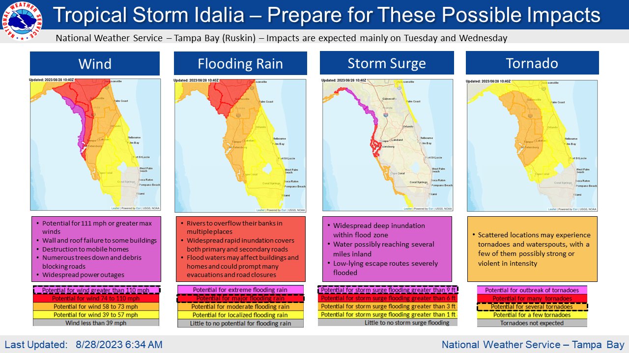
According to the National Hurricane Center (NHC), there is a danger of life-threatening storm surge inundation along portions of the Florida Gulf Coast where a Storm Surge Warning is now in effect, including Tampa Bay and the Big Bend region of Florida. Inundation of 8-12′ above ground level is now expected somewhere between Chassahowitzka and Aucilla River. Widespread deep inundation is expected in the flood zone and water could possibly reach several miles inland. Low-lying escape routes will likely be severely flooded or compromised during the storm.
Hurricane wind conditions are expected within portions of the Hurricane Warning area along the Florida Gulf Coast, with the potential for destructive winds where the core of Idalia moves onshore. Strong winds will also spread inland across portions of northern Florida near the track of the center of Idalia.
Areas of flash and urban flooding, some of which may be locally significant, are expected across portions of the west coast of Florida, the Florida Panhandle, and southern Georgia Tuesday into Wednesday. This threat will spread into eastern portions of South and North Carolina on Wednesday into Thursday.
Scattered locations across western Florida may experience tornadoes and waterspouts. The National Weather Service warns that some tornadoes and waterspouts may be possibly strong or violent in intensity.
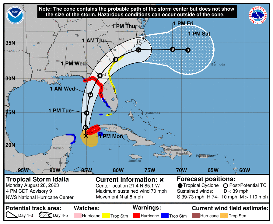
As of the latest update from the NHC, Idalia was a strong tropical storm packing maximum sustained winds of 70 mph about 265 miles south-southwest of the Dry Tortugas and about 25 miles south-southwest of the western tip of Cuba. The storm was moving due north at 8 mph while having a minimum central pressure down to 987 mb to 29.15″.
Many watches and warnings have been extended prior to Idalia’s arrival. The Storm Surge Warning has been extended westward to Indian Pass Florida. The Hurricane Warning has also been extended westward to Indian Pass. A Tropical Storm Warning has been issued from west of Indian Pass westward to Mexico Beach. The Storm Surge Watch along the southeast coast of the United States has been extended northward to South Santee River. The Tropical Storm Watch along the southeast coast of the United States has been extended northward to South Santee River.
Please observe all local official requests and flee evacuation zones if asked. Do so calmly and cautiously, but do so as quickly and as safely as you can. #FLwx #Idalia https://t.co/FDxX7sUkAI
— the Weatherboy (@theWeatherboy) August 28, 2023
According to the NHC, a northward motion is expected through tonight, followed by a faster north-northeast motion on Tuesday and Wednesday. On the forecast track, the center of Idalia is forecast to pass near or over western Cuba tonight, over the eastern Gulf of Mexico on Tuesday, and reach the Gulf coast of Florida within the Hurricane Warning area on Wednesday. Maximum sustained winds are near 70 mph with higher gusts. Rapid strengthening is predicted during the next day or so and the NHC expects Idalia to become a hurricane this evening or tonight, and become a major hurricane by late Tuesday or Tuesday night. Major hurricanes have sustained winds of 120 mph or greater.
The combination of a dangerous storm surge and the tide will cause normally dry areas near the coast to be flooded by rising waters moving inland from the shoreline. The water could reach up to 8-12′ in the area between the Aucilla River and Chassahowitzka; 4-7′ storm surge is possible in Tampa Bay. Even the Florida Keys could see a 1-2′ storm surge from this storm system. The deepest water will occur along the immediate coast in areas of onshore winds, where the surge will be accompanied by large and dangerous waves. Surge-related flooding depends on the relative timing of the surge and the tidal cycle, and can vary greatly over short distances.
Portions of the west coast of Florida, the Florida Panhandle, southeast Georgia and the eastern Carolinas are expected to get 4-8″ of rain from Tuesday into Thursday. Isolated higher totals of a foot are possible, primarily near landfall in northern Florida.
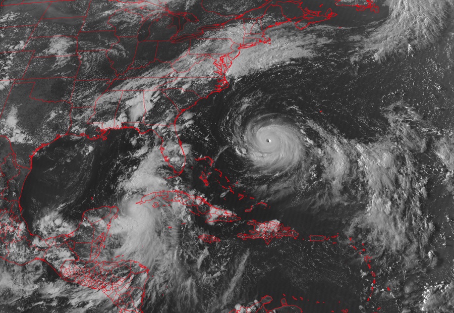
Elsewhere in the Atlantic, Hurricane Franklin continues to spin about. As Idalia grows too, it is likely that there will be two major hurricanes at the same time in the Atlantic Hurricane Basin by Wednesday. If that occurs, it’ll be only the third time on record since 1851 there were two simultaneous major hurricanes in the basin in August. The other years this happened were in 1886 and 1893.
