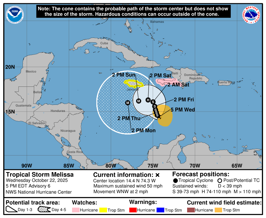
According to the National Hurricane Center in Miami, Florida, Tropical Storm Melissa is now expected to strengthen into a Major Hurricane with winds of 115 mph or more this weekend. The slow moving storm is drifting in the Caribbean Sea, prompting governments to issue different types of advisories for their islands.
A Hurricane Watch is now in effect for the southwestern peninsula of Haiti from the border with the Dominican Republic to Port-Au-Prince. A Tropical Storm Watch is in effect for Jamaica. A Hurricane Watch means that hurricane conditions are possible within the watch area. A watch is typically issued 48 hours before the anticipated first occurrence of tropical-storm-force winds, conditions that make outside preparations difficult or dangerous. A Tropical Storm Watch means that tropical storm conditions are possible within the watch area, generally within 48 hours.
As of the latest update from the National Hurricane Center (NHC), Melissa was located about 320 miles south-southwest of Port Au Prince, Haiti and about 300 miles southeast of Kingston, Jamaica. With maximum sustained winds of 50 mph, the storm’s minimum central pressure is down to 1000 mb or 29.53″.
The latest view of Melissa shows an impressive storm that continues to barely move: pic.twitter.com/dzZkdxL6DL
— the Weatherboy (@theWeatherboy) October 22, 2025
Melissa is moving slowly toward the west-northwest near 2 mph. According to the NHC, a slow forward speed and a gradual turn to the northwest or north-northwest is forecast during the next couple of days, followed by a turn back westward by this weekend. On the forecast track, Melissa is expected to approach Jamaica and the southwestern portion of Haiti later this week. Meanwhile, some slow strengthening is forecast during the next few days, and Melissa could become a hurricane by Friday, with more substantial intensification forecast by this weekend. The NHC officially forecasts Melissa reaching Major Hurricane status by Sunday afternoon.
Beyond the weekend, little is known about Melissa’s future path. Computer forecast models are split on the storm’s future direction, with a lack of atmospheric steering able to push the storm in one direction or the other in the immediate future. By the weekend, scientists should know better where this powerful hurricane could head next.
Some guidance has suggested the storm could eventually head to the Mid Atlantic around Halloween; other guidance suggests conditions will be ripe for a powerful nor’easter to be spawned due to Melissa’s presence in the western Atlantic. It is too soon to say with any certainty what will happen with this storm.
Before then, parts of the Caribbean will be lashed by severe wind and heavy rain.
Hurricane wind conditions are possible within the watch area in Haiti beginning on Friday. Tropical storm conditions could begin in Jamaica late on Thursday or Friday.
Melissa is expected to bring 5-10″ of rain to the southern Dominican Republic, southern Haiti, and eastern Jamaica through Saturday, with locally higher amounts possible. Additional heavy rainfall is possible beyond Saturday.
“However, uncertainty in Melissa’s track and forward speed reduces confidence in exact totals,” cautions the NHC. They add that significant, life-threatening flash flooding and numerous landslides are possible.
Across Puerto Rico, northern Dominican Republic, northern Haiti, and western Jamaica, 2-4″ of rain is expected through Saturday. Flash and urban flooding will be possible through at least Saturday.
