A weather disturbance moving through the country may bring light snow to portions of the Mid Atlantic late Thursday into early Friday. While computer forecast models are suggesting very different scenarios, the National Weather Service says they have increasing confidence that light snow will fall across portions of Virginia and North Carolina before the storm exits the coast Friday
A strong shortwave trough is forecast to dive out of the Great Lakes regions Thursday morning and interact with the now stalled frontal boundary in the south which is forecast to trigger cyclogenesis off the southeast coast. The shortwave will pivot southeastward through the Ohio Valley, while a strong jetstream will drive off the Mid Atlantic coast. With this type of set-up, surface cyclogenesis is expected off of the Carolina coast. As cold air advection arrives late Thursday, morning rain is forecast to change over to plain snow from west to east. Light snow should continue overnight before ending early Friday as the storm heads east off-shore. With high pressure in place over the northeast and no blocking pattern existing over the North Atlantic, this system will not have the opportunity to turn up the coast and bring snow to the big cities along the I-95 corridor from Washington, DC north.
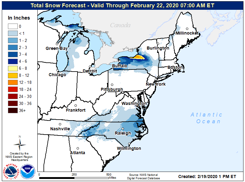
For now, it appears that 1-2″ of snow is possible along and west of Highway 17 with lighter accumulations elsewhere. Because precipitation is starting as plain rain with mild soil temperatures, snow will struggle to accumulate at first. As such, most accumulating snow will occur on grassy surfaces rather than paved ones. Should colder air arrive sooner, that could change, but it is not something expected by most global computer forecast models nor local National Weather Service offices.
