While many in the northeast are cleaning up after the Monster March storm that brought damaging winds, coastal flooding, and heavy wet snow to a large area, eyes are back on the forecast for a mid-week storm expected to bring mayhem back to the region in the form of snow.
Prior to the storm’s mid-week arrival, some calm will return to a region that needs it after a busy end-of-week high-impact event. High pressure centered near Hudson Bay in Canada will continue to nose southward down into the eastern United States today and tomorrow. The pressure gradient responsible for the gusty winds in the northeast will weaken through Monday night as this ridge axis progress east while the off-shore storm pulls farther away from the US.
Similar to the evolution of yesterday`s storm system, a primary low is expected to track eastward across the
Midwest/Ohio Valley, then redevelop just off the Mid-Atlantic coast. Computer forecast models are clustering around two general scenarios with how this storm could pan-out; data coming in today is suggesting the second scenario is the more likely of the two.
The first set of forecast model guidance suggests a quick-moving, progressive storm system. A progressive solution would favor the coastal low to track faster out to sea. On such a flat and fast track, the phasing with a trailing northern stream shortwave trough over the Great Lakes is limited. Due to that limitation, such a scenario would have a quick hit of snow and rain to the northeast with minor to moderate accumulations of snow on the northern side of the system.
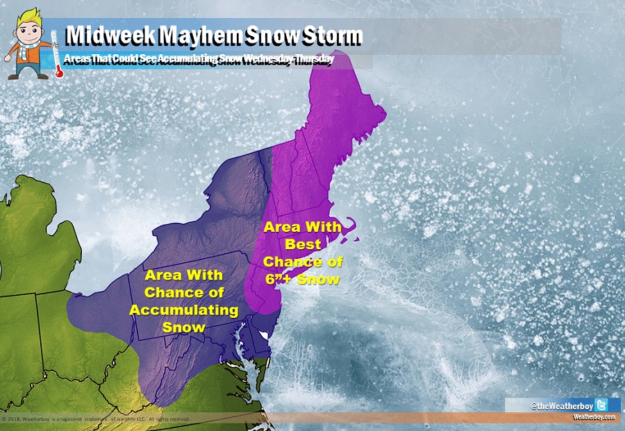
The second and more likely modeled solution shows a strengthening system that “bombs-out” near the coast. This amplified forecast output supports a steady deepening of the coastal low as it phases with the upstream trough. Currently, models do not indicate secondary cyclogenesis to be as intense as yesterday’s storm but it would still be a formidable system. Mean sea level pressure would lower to around 995mb on the New Jersey coast by midday Wednesday and deepen further to a 985mb low as it nears Cape Cod by late Thursday. If this scenario were to play out, Atlantic moisture would be advected inland and heavier precipitation could expand westward due to the phasing of the low as the nor’easter rolls-out.
This more substantial modeled storm solution would yield heavier snow. Such a low track would be favorable for late season snow, especially away from the coast. However, without a strong high anchored just to the North in Canada, the cold air would have to be generated from the coastal storm itself via dynamical cooling, especially along and south and east of I-95 where temperatures will initially be warm in a similar fashion to what was seen with yesterday`s storm.
The National Weather Service (NWS) is concerned about this stronger scenario playing out, with regional forecast offices issuing updates on the storm prospects today. The Mount Holly, New Jersey office of the NWS said today in a forecast discussion, ” Given the growing support with today`s 12Z runs for a moderate to heavy precipitation event and the ongoing restoration efforts following yesterday’s storm that will likely continue for the next several days across the hardest hit areas, we want to be proactive with getting the message out on another potential impactful event even if the details are still unclear this far out.”
After impacting the region on Wednesday, the storm system will eventually pull to the north and east, with gradually improving weather conditions on Thursday. The speed of that recovery and the time of strong winds in the wake of the storm will be dependent on actual storm track and intensity.
