A much advertised weather system will bring a round of snow across the northeastern United States during the midweek period. An area of low pressure is forecast to pass across the southern and eastern Great Lakes tonight and Tuesday. A secondary low pressure system is expected to develop off the Middle Atlantic coast on Tuesday night before moving northeast toward Canada`s Maritime Provinces on Wednesday. The fast-moving low arriving from the Great Lakes region is known as a “clipper system”, called such because it it moves along fast like a clipper ship. The clipper will pull a cold front into the Mid Atlantic from the west on Tuesday night, with snow arriving then. The secondary low pressure system will blossom off the Mid Atlantic coast Tuesday night; it will deepen off the southeastern New England coast and head into the Maritimes. Because the low isn’t expected to develop and deepen until it reaches the New England coast, snowfall amounts will be light across the Mid Atlantic and heavier in New England.
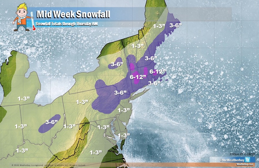
A widespread 1-3″ is expected from the clipper from Michigan, Indiana, and Kentucky east into West Virginia and Pennsylvania. Light snow is also expected around central North Carolina and Virginia and north and east up the northeast coast. Due to the urban heat island effect, snow totals from this system will likely be on the lower end of the 1-3″ range for places like Washington, DC, Baltimore, MD, Philadelphia, PA, and New York City, NY. Some amounts may also struggle to reach even 1″ across portions of the South Shore of Long Island, the immediate Jersey Shore, and Maryland and Delaware Beaches; in these locations, marginal temperatures near the ocean may help mix some rain in with the snow, which would keep amounts down there. However, areas of New England which will be closer to the intensifying coastal storm will see heavier amounts. 6-12″ is possible across the higher terrain of southern Vermont, portions of Massachusetts, and north central Connecticut. Between the heavy and light snow regions, an area of moderate snowfall amounts of 3-6″ are possible across central and northeastern Pennsylvania, northwestern New Jersey, southeastern Upstate New York, up the New England Coast. A band of 3-6″ is also possible in central Ohio tonight into tomorrow morning as the Clipper swings through there.
Snow will wrap up from southwest to northeast on Wednesday as high pressure returns. High pressure is expected to build across the southeastern and Middle Atlantic states late in the week before moving over the western North Atlantic during the weekend. The high is forecast
to bring dry weather conditions and a gradual warming trend.
